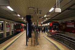
Ebertplatz underground station
| Ebertplatz | |
|---|---|
| Underground station in Cologne | |
 Change between high and low floor |
|
| Basic data | |
| District | Downtown |
| Opened | 1974 |
| Newly designed | 2008 |
| Tracks (platform) | 4 (2 central platforms) |
| Coordinates | 50 ° 57 '2 " N , 6 ° 57' 28" E |
| use | |
| Stretch) | Inner city tunnel , rings tunnel |
| Line (s) |
12 15
16 18 |
| Switching options | Bus: 127
140 186 |
The Ebertplatz underground station is the largest underground junction of the Cologne city railway . It is designed as a four-track crossing station that is used in one direction . The Ebertplatz is one of the most important transfer points between high-floor and low-floor network and is frequented daily by nearly 35,000 in and outs.
history
Ebertplatz was already an important junction for the Cologne tram . In the course of the first expansion of the underground tram network, the entire junction was moved underground. In contrast to the previous tunnels, great importance was attached to the efficiency of the system - also due to the initial funding from state funds. Almost all routes can be used without crossing other routes. For this purpose, uneven branches were created underground . In addition, the bus stop system has an underground turning loop .
The station was originally designed for use with mover carriage designed. In addition to the turning loop, this is also evidenced by the fact that originally there was a side platform to the right of each track , with the outer tracks originally even being separated from the inner tracks by barriers . The platforms were every 35 cm above the top of the rails. A later increase in the platforms for high-floor light rail cars was planned from the start; in particular, all escalators ended at 90 cm and could only be reached from platform level via ramps .
Since the relocation of line 12 from the inner city to the rings tunnel in December 2003, the station has been completely free of intersections, and the high-floor and low-floor lines have been running on separate tracks since then. This made a barrier-free conversion possible. The problem arose that the original planning had assumed that in the medium term all lines would be converted to high-floor light rail vehicles. The shell structure only allowed the track heights to be changed by a few centimeters, which is why the central platforms had to be divided lengthwise into platforms of different heights. Since the central platforms were considered too narrow for this, it was finally decided to move the outer tracks to the area of the side platforms that were no longer required, thereby gaining space for widening the central platforms.
The renovation began in the spring of 2008 and ended in March 2009, with the outer tracks being moved during a six-week closure during the school summer holidays. At the same time, elevator shafts were created from the platforms to the square.
| Previous station | Cologne light rail | Next station | ||
|---|---|---|---|---|
|
Lohsestrasse ← Merkenich |
12 |
Hansaring folding rule Südfriedhof → |
||
|
Lohsestrasse ← Chorweiler |
15th |
Hansaring Ubierring → |
||
|
Breslauer Platz / Hbf ← Bonn-Bad Godesberg |
16 Rheinuferbahn |
Reichenspergerplatz Niehl Sebastianstraße → |
||
|
Breslauer Platz / Hbf ← Bonn Central Station |
18 Foothill Railway |
Reichenspergerplatz Thielenbruch → |
||
Web links
- Commons : Ebertplatz U-Bahn station - collection of images
- further information about the subway station, including 3D map (KVB)
Individual evidence
- ↑ Priorities for platform elevation and elevator retrofitting in the Cologne light rail network . Transport Committee of the City of Cologne. May 18, 2008. Retrieved March 6, 2010.

