Wake-up snap
As Weckschnapp a medieval tower is a modern extension on the left bank of the Rhine the Rhine referred that part of the medieval city wall of Cologne was.
The "Weckschnapp" legend
The name Weckschnapp refers to a Cologne legend that tells of a particularly cruel form of execution . The guards are said to have hung a wake (a small piece of bread) on the ceiling of the prison room on the upper floor of the tower. Since the prisoners did not receive any further food, after some time they tried to catch the “Weck” by jumping up (“snap”) and then rushed onto an opening trap door through a knife-tipped shaft in the tower directly into the Rhine. Only one prisoner who was particularly emaciated was said to have escaped. It was so thin that it fell through the knives without touching them.
The saga appears for the first time in writing in 1826 in a work by the Cologne writer Ernst Weyden (1805–1869) as a short prose story with the reference "Oral" and the introduction:
"At the northern end of the city of Cologne, at the St. Kunibertskirche, a tower was built on a ledge, which among the people was called:" Die Weckschnapp ", which is the name of the most gruesome legends."
The core of the legend is likely to tie in with the assumed function of the Kunibert Tower (northern counterpart of the Bayenturm ) as a prison and place of "embarrassing interrogation". The preserved turret, however, is demonstrably not the place from which the legend reports. This tower has never had a connection to the Rhine and prisoners were not held in such an exposed place. It is more likely that the legend originally refers to an "Ark", a part of the fortification standing in the Rhine, which was connected to the Kuniberts fortification by means of a battlement bridge. This "Ark" was largely destroyed in the great flood of 1784 .
The name "Weckschnapp" was evidently transferred to this only surviving part of the Kuniberts fortification in the 19th century and also found its way into official maps. In the current German basic map, however, it is referred to as the "Kunibertsturm".
The "Kunibert Tower"

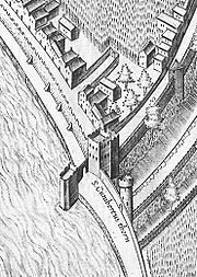
The "Kunibertstürmchen" has been proven since 1446. It belonged to the part of the earlier city fortifications of the Kunibertstorburg in front of the city wall , the structure of which corresponded to the fortifications on the Bayenturm. The gate, tower and ark, which later became a bastion, are clearly visible in Arnold Mercator's 1570 view of Cologne . The "Kunibertstürmchen" was connected to the Kunibert Tower with a battlement on a high wall.
Since this tower in front of the city wall was unique in Cologne, it was often used to describe the location until the 19th century, e.g. B. Port or train station "am Türmchen". The tower can also be found in street names: "Thürmchenswall" for Wallstrasse to Eigelstein or the submerged "Thürmchensgasse" on the Rhine front.
In the course of the demolition of the city wall from 1881, the Kunibert fortifications were also demolished in 1895. Like the remaining city gates, the preserved turret was also restored by the city architect Josef Stübben .
The "Kunibertstürmchen" survived the Second World War without major damage.
In 1956 the architect Martin Kratz first expanded the tower for residential purposes. After the land issue was resolved, he started a single-storey residential building.
literature
- Paul Clemen (Hrsg.): The art monuments of the city of Cologne, second volume, IV. Section, the profane monuments . 1930
Individual evidence
- ↑ Ernst Weyden: Cöln's Vorzeit. Cöln am Rhein, Pet. Schmitz, 1826, p. 186; PDF accessed on Wikimedia Commons
- ^ Adam Wrede: Neuer Kölnischer Sprachschatz , Volume S – Z, page 265
Web links
Coordinates: 50 ° 56 ′ 57.7 " N , 6 ° 57 ′ 55.3" E

