
Baakenhafen
The Baakenhafen is a harbor basin in Hamburg and at the same time namesake of the surrounding part of the Hamburg HafenCity .
Harbor basin

The harbor basin is located east of the entrance to Magdeburg harbor , parallel to the Norderelbe , on the opposite side of the Vltava harbor . The harbor basin is 130 meters wide and 1.5 kilometers long. In the course of the development of HafenCity, however, land reclamation measures made it smaller in both length and width. Nowadays the harbor basin is in three parts of the HafenCity. The western end is in the Elbtorquartier , the middle area in the eponymous Baakenhafen quarter and the eastern end in the Elbbrückenquartier .
history
The harbor basin was built in 1887. Between 1893 and the completion of the Kaiser-Wilhelm-Hafen , the facilities at Petersen-Kai were leased to the then rapidly expanding Hamburg-American Packetfahrt-Actien-Gesellschaft . The shipping company Deutsche Ost-Afrika-Linie (from 1950 "Deutsche Afrika-Linien") leased these southern quays. From 1973 on, the Czechoslovak Elbe Shipping Company (ČSPL) used some of the facilities, including the 9,000 m² shed no. 23 and 450 linear meters of quay facilities.
Since the resolution of the Hamburg Senate in 1998, the port basin and the surrounding headlands have been formally part of the HafenCity project , in which the port areas south of Hamburg's inner city are released from their original use and converted into retail, commercial, residential and leisure-related areas should be.
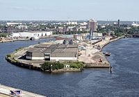
Baakenhöft in 2011

Industrial plants in Baakenhafen in 2010


HafenCity


The Baakenhafen sub-district is located in the eastern part of HafenCity and comprises the western part of the harbor basin and the two surrounding headlands. It is bounded in the north by the viaduct of the pillar railway , in the northwest the Baakenhafen borders on the Am Lohsepark quarter and in the east on the Elbbrücken quarter .
In May 2010 the revised and specified master plan for the eastern part of HafenCity was presented. The main uses of the quarter are to be residential and leisure-related uses, with hotels and office uses also to be represented to a lesser extent. On the south-western tip of the quarter, an unspecified prominent use is also planned; the master plan provides for a building height of up to 70 meters for this. The building density will be based overall on the already completed sub-district Am Sandtorkai / Dalmannkai .
The revised version provides for the following measures as major changes compared to the first version of the master plan:
- Downsizing of the quarter by handing over the eastern part to the neighboring Elbbrücken quarter
- Increase in building density
- Greater differentiation of the building typologies
- Pointing the Baakenhöft through prominent, multi-storey buildings
- Creation of additional connections between the north and south of the district
- Extension of the Lohsepark into the quarter
- Filling up an approximately 1.5 hectare island in the eastern part of the harbor basin as a green and leisure facility
The first plots of land in the district are to be put out to tender in 2011; the first structural measure was a new bridge (Baakenhafenbrücke) laid over the harbor basin in June 2013. A design by the engineering office Wilkinson Eyre Architects from London won the architectural competition . Reference object: Gateshead Millennium Bridge . The bridge was opened with a public festival on August 10, 2013.
In 2020, the temporary Baakenhöft cruise terminal was completed in Baakenhafen. It will serve as an alternative terminal and will also be used as a multifunctional event location.
Public transport
The development, especially of the north-western part of the quarter, is mainly via the HafenCity Universität underground station on the U4 line . The eastern part is in the neighborhood Elbbrucken located underground and railway station Elbbrucken same subway line and tram lines S3 and S31 developed with. Bus stops are also planned at Baakenhöft and Baakenallee.
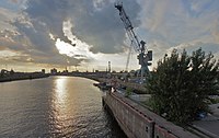
Quay crane on Versmannstrasse on the north side of the harbor basin

The Stubnitz in Baakenhafen

Baakenhafenbrücke on the west side of the Baakenhafen


Olympic planning
As part of Hamburg's application to host the 2012 Summer Olympics , the area around Baakenhafen was included in the planning of the Olympic sports facilities. The facility for the swimming competitions should have been built on Baakenhöft in the far west of the southern headland.
As part of the application for the Olympic Summer Games 2024 , no use for the Olympic competition venues was planned on the area of the quarter. These should take place entirely on the area of the neighboring Kleine Grasbrook .
See also
Web links
- HafenCity.com on the Baakenhafen district
- Brochure about the planning of the Baakenhafen (PDF; 24.9 MB)
- Brochure about the bridge Baakenhafen West (PDF; 3.2 MB)
- Bridge Baakenhafen West on the website of the architect
Individual evidence
- ↑ Bruno Muhs: On the transition of the waterways, which are important for traffic, into the property of the Reich . Hartung, Kiel 1927, OCLC 174732857 , p. 103 ( books.google.com - dissertation, restricted view).
- ↑ Gustav Braun: Germany: represented on the basis of own observation, the maps and the literature. Volume 1. Gebr. Borntraeger, Berlin 1916, p. 98 ( archive.org ).
- ^ Peter Borowski: Hamburg and the free port . In: Highlights of historical research. Studies on German history in the 19th and 20th centuries . Hamburg Univ. Press, Hamburg 2005, ISBN 3-937816-17-8 , pp. 122–123 ( hup.sub.uni-hamburg.de [PDF]).
- ↑ Traces of History, Part 1 (PDF; 9.0 MB) HafenCity Hamburg. P. 44. Retrieved November 12, 2010.
- ↑ Ivan Jakubec: Loopholes in the "Iron Curtain". Czechoslovak-German transport policy in the Cold War. The railroad and Elbe shipping 1945–1989 . Franz Steiner Verlag, Stuttgart 2006, ISBN 3-515-08527-0 , pp. 190 ( books.google.com - excerpt).
- ↑ Homepage HafenCity Hamburg: Baakenhafen bridge , accessed on February 6, 2011.
- ↑ TrendJam Magazine: Baakenhafen Quartier gets Baakenhafenbrücke and first buildings in 2014 , accessed on August 10, 2013.
- ↑ Hamburg suddenly has a new cruise terminal. Hamburger Morgenpost, accessed on June 13, 2020 .
- ↑ Public transport target concept of HafenCity ( Memento of the original from March 16, 2017 in the Internet Archive ) Info: The archive link was inserted automatically and has not yet been checked. Please check the original and archive link according to the instructions and then remove this notice.
- ↑ Hamburg für Spiele 2012 GmbH (Ed.): Fire and Flame for Hamburg 2012. Presentation of the organizing committee of the application for hosting the Olympic Summer Games 2012 in Hamburg. ( hk24.de ( page no longer available , search in web archives ) Info: The link was automatically marked as defective. Please check the link according to the instructions and then remove this notice. PDF) Retrieved on: January 28, 2010.
Coordinates: 53 ° 32 ′ 20 ″ N , 10 ° 0 ′ 40 ″ E