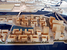
Elbe bridge district
The Elbbrückenquartier is a planned part of the HafenCity in Hamburg . It is expected to be developed from 2018 and is to be developed alongside the Überseequartier, which will be completed by 2021/22, as the second urban center of HafenCity with the main uses of residential, commercial and hotel business.
location
The quarter is located in the far east of HafenCity and includes the area around the Elbe bridges and the eastern part of the historic Baakenhafen . In the west it borders on the sub-district of the same name and is bordered in the north by the high-level railway line of the pillar railway , in the east by the Oberhafen Canal and in the south by the Norderelbe . The railway line also runs through the eastern part of the quarter.
use
Elbbrücken will have a mixed use structure with a focus on living and office. The central open space of the western part of the quarter and part of the banks of the Elbe are lined with residential uses, while the buildings along the pillar railway and the Elbe Bridge Center are to be provided primarily for office use. Hotel uses are planned selectively, including in the Elbe Bridge Center . Most of the quarter's ground floor zones are intended for public use such as retail, services and restaurants.
Urban planning
The concrete plans for the quarter were presented on May 26, 2010 as part of the presentation of the revised master plan for eastern HafenCity. At this time the name of the quarter was changed from Elbbrückenzentrum to Elbbrücken . In the new master plan, the Elbbrückenzentrum is the name of a high-rise ensemble planned in the east of the quarter.
The changes to the master plan include the following points in particular with regard to urban development statements:
- Expansion of the quarter to the west while reducing the neighboring Baakenhafen quarter
- Extensive interventions in the existing structure; the eastern part of the Baakenhafen will be separated from the rest of the area and converted into a tide-independent, stagnant body of water and thus more closely integrated into the design of the square
- Restructuring and densification of the development of the western part of the quarter
- Concentration of high-rise development on fewer, larger buildings
- clearer staggering of the building heights from west to east
- Additional connection to the City Süd by a road bridge over the Oberhafen .
The quarter is essentially divided into a western and an eastern part; in the west, the planned Amerigo-Vespucci-Platz and the separated part of the Baakenhafen form the central urban reference point around which the six to seven-storey building blocks are grouped. The building structure is based much more clearly on the structure of the Am Sandtorkai / Dalmannkai district . 14-storey solitaires on the northern edge and in the east around Amerigo-Vespucci-Platz form the structural framework of the western part of the district. The area to the east of this is largely shaped by the aforementioned group of high - rise buildings, the three individual buildings of which will be around 200 meters or 50 storeys high. This would make them the tallest buildings in Hamburg after the Heinrich Hertz Tower . The Elbbrückenzentrum to a representative and distinctive entrance area to downtown Hamburg for users of the Elbe bridges formulate from the south due to its location.
development
As a first measure, the existing warehouse buildings in the southern part of the quarter were demolished in 2013. Since 2014 the quay wall on the Elbe side has been renovated and the main southern access road built. More roads have been built since 2015, as that was underground - U4 extended to the Elbe.
Public transport
The central carrier of public transport is to be the U4 subway line , which has been extended beyond its previous terminus at HafenCity University and has a new stop in the district directly in front of the Elbe bridge. For this purpose, the line was initially continued underground east of HafenCity University and comes to the surface in the eastern area of Versmannstrasse in order to reach the (provisional) terminus Elbbrücken , which is also above ground . A decision was therefore made against an alternative Baakenhafen station further west . The link with the S-Bahn and the proximity to the Elbe bridge center speak in favor of the chosen solution .
In the past, a new S-Bahn station was primarily planned for the development, which was named Zweibrückenstrasse . It essentially corresponds to the connection point with the subway proposed in the concept.
Individual evidence
- ^ HafenCity Hamburg GmbH (ed.): HafenCity News Extra. Master plan revision of the eastern HafenCity. Self-published, Hamburg 2010
Coordinates: 53 ° 32 ′ 5 ″ N , 10 ° 1 ′ 30 ″ E


