Docklands
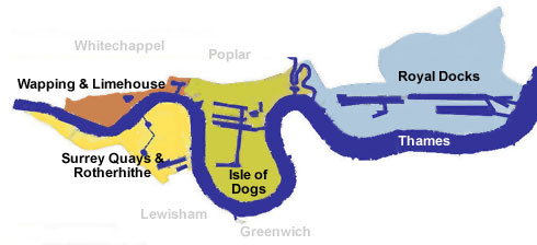
Docklands is the semi-official name of a district in east London . It consists of parts of the boroughs of Southwark , Tower Hamlets , Newham , Lewisham and Greenwich . The eponymous docks were formerly part of the Port of London, once the largest port in the world. Shipping was given up and the fallow land was converted for residential and business purposes. Large office building complexes such as Canary Wharf were built .
Docklands areas
The Docklands consist of a series of former dock and shipyard complexes along the Thames . From west to east these are:
- St Katharine Docks (Wapping)
- London Docks (Wapping)
- Limehouse Basin (Limehouse)
- Surrey Commercial Docks (now Surrey Quays, Rotherhithe )
- West India Docks and Millwall Dock ( Isle of Dogs )
- East India Docks (Canning Town)
- Royal Docks ( Royal Victoria Dock , Royal Albert Dock , King George V Dock )
Another dock area is located further downstream in Tilbury , but is not counted as part of the Docklands.
history
Development of the docks
In Roman times as well as in the Middle Ages , ships moored at small docks, either in the City of London or in Southwark ; an area known as the Pool of London . The biggest problem was that there was no protection against the forces of nature and thieves. In addition, there was an enormous lack of space on the quay side. Therefore, a dock was built further downstream for the first time in 1696. The Howland Great Dock (later Greenland Dock ) in Rotherhithe formed the centerpiece of the later Surrey Commercial Docks. This new port now offered large, safe and protected space for 120 ships. It was immediately a great commercial success and formed the basis for future expansions.
Under the reign of King George III. and George IV , the West India Docks (1802), the East India Docks (1805), the Surrey Docks (1807), the St Katharine Docks (1828) and an extension of the West India Docks (1829) were created. Under the reign of Queen Victoria , the port area expanded even further east: Royal Victoria Dock (1855), Millwall Dock (1868), Royal Albert Dock (1880). The last expansion was the King George V Dock in 1921.
Docks and dock workers
There were three different types of docks. The ships anchored in the wet docks and were loaded and unloaded. Individual ships were repaired in significantly smaller dry docks. Ships were built in shipyards on the riverside. The docks were surrounded by countless warehouses, piers, and wharfs. Over time, individual docks specialized in certain goods: In the Surrey docks, for example, B. Turned timber , Millwall grain , St Katharine Docks wool , sugar and rubber .
A huge number of workers were required for the docks . Some were highly specialized, but most were not even educated. They had to go to certain places every morning (mostly pubs ), where foremen would pick them more or less at random. It was a lottery for these workers every day to see whether they could even work and earn money. This type of employment lasted until 1965, even if it was guided into somewhat regulated channels by law in 1947.
Most of Docklands developed in swampy and sparsely populated terrain that was unsuitable for agriculture . The dock workers formed numerous close-knit local communities; each had its own culture and slang . These communities lived far from the city center and tended to isolate themselves. The local patriotism was so far advanced that, for example, in 1920 the inhabitants of the Isle of Dogs blocked the only two roads out and declared their independence.
The docks in the 20th century
The docks were originally built and operated by a number of competing private companies. In 1909 the Port of London Authority (PLA) was established. She took over the private companies in order to make port operations more efficient and to improve the relationship with the “Dockers”. The PLA built the last dock in 1921, the King George V.
The bombing by the German Air Force in World War II caused huge damage. Many docks were not passable after the end of the war. Nevertheless, the Docklands experienced a period of increasing prosperity in the 1950s. The end came suddenly, between 1960 and 1970, when container ships were introduced on a large scale. The London docks were suddenly much too small to be able to handle the larger ships at all. The entire port industry moved further downstream to the deep-sea ports in Tilbury and Felixstowe . Between 1960 and 1980 all docks in London were closed. The unemployment rate was high, the area impoverished, the buildings fell into disrepair.
A new district is emerging
Ideas to convert the docks for new purposes came up almost immediately after they were closed. However, it took around two decades for the first measures to be implemented. The situation was complicated by the large number of landowners who all wanted to advance their own interests. In addition to the PLA, this also included the Greater London Council , gas works, five London boroughs , British Rail and the then state-owned electricity company CEGB .
To solve this problem, Environment Secretary Michael Heseltine formed the London Docklands Development Corporation (LDDC) in 1981 ; an authority that was directly subordinate to the government, could buy and sell any land and took on the role of central planning authority. Another important measure was the creation of an Enterprise Zone on the Isle of Dogs in 1982 , where companies were exempt from property tax and benefited from simplified licensing procedures. This made investing in Docklands extremely attractive and triggered a real estate boom.
The LDDC was controversial because it did not respond to the needs of the population. She was accused of concentrating exclusively on elitist urban development projects instead of also looking at affordable housing. Nevertheless, the conversion would never have progressed so quickly without the LDDC. It was dissolved in 1998 when the boroughs regained full control of their own territory.
Under the leadership of the LDDC, large areas of Docklands were converted into residential and commercial zones in the 1980s and 1990s. The centerpiece of the transformation process was undoubtedly Canary Wharf , where the three tallest buildings in Great Britain were erected and where the international financial industry settled. The Canadian company Olympia and York , which built the building complex, went bankrupt in 1992 when real estate prices plummeted and large sections of the new commercial buildings initially proved unlet.
The Docklands were initially very poorly served by public transport . This was partially offset by the construction of a driverless elevated train ; the first section of the Docklands Light Railway went into operation in 1987. In the same year, London City Airport was opened on the premises of the Royal Docks . Crucial for Canary Wharf's commercial and urban breakthrough were the greatly improved real estate boom in the late 1990s and the direct connection of Docklands to the London Underground network in 1999 when the Jubilee Line was extended eastwards. Succeeded Paul Reichmann , the leader of Olympia and York again to win crucial part of a new consortium influence on the now booming Canary Wharf.
Docklands today
The number of inhabitants has more than doubled in the twenty years since the new developments began. The Docklands have developed into a business center and an exclusive residential area. Not all of the old warehouses and shipyards were demolished, but were converted into apartment buildings and shopping centers. The former docks are used as marinas or water sports centers.
The transformation of Docklands was not all positive. The steep rise in prices during the real estate boom created tensions between the newcomers and the long-established dockworker population, which feels increasingly marginalized. A sharp contrast can be observed in many places, with expensive luxury apartments next to run-down social housing .
Further development
The continued success of the Docklands redevelopment resulted in a number of infrastructure projects:
- Extensions of the Docklands Light Railway , u. a. to Woolwich and Dagenham
- Construction of a new S-Bahn- like railway line ( Crossrail )
- Other buildings at Canada Water
- Conversion of Blackwall Basin and Wood Wharf, west of Canary Wharf
- Further conversions in the Royal Docks, such as B. the Silvertown Quays project
- In 1988 the art exhibition Freeze took place there.
literature
- Chris Ellmers and Alex Werner: Dockland life: a pictorial history of London's docks 1860-2000 . Museum of London., NA (1st ed. 1991) Edinburgh [u. a.]: Mainstream 2000, 221 pp., ISBN 1-8401-8318-7
- Sue Brownill: Developing London's Docklands: Another Great Planning Disaster? British Library of Cataloging in Publication Data, NA (1st ed. 1990) London [u. a.]: Paul Chapman Publishing Ltd., 196 pp., ISBN 1-85396-098-5
- SK Al Naib: London Docklands: Past, present and future . NA (1st edition 1990) London [u. a.]: Ashmead Press Ltd., 60 pages, ISBN 0-901987-81-6
- Stephanie Williams: Phaidon Architecture Guide Docklands . British Library, NA (1st ed. 1990) London [u. a.]: Phaidon Press Ltd., 168 pp., ISBN 0-71482789-4
- Elizabeth Williamson, Nikolaus Pevsner: The Buildings of England: London Docklands - An Architectural Guide . The Building Books Trust, NA (1st ed. 1998) London [u. a.]: Penguin Group., 320 pp., ISBN 0-14071096-5
Web links
- Museum of London Docklands (English)
- History of Docklands (1981–1998 )
- Literature on the London Docklands district in the catalog of the German National Library
Coordinates: 51 ° 30 ′ 26.9 ″ N , 0 ° 2 ′ 18 ″ E


