West India Docks
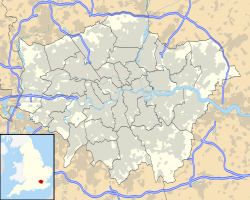
Location of the West India Docks in Greater London |

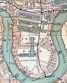
The West India Docks are a group of three docks on the Isle of Dogs in London's East End .
The reason for the construction of the port facilities
Robert Milligan (1746-1809) was the main person responsible for the construction of the West India Docks. Milligan was a wealthy West India trader and shipowner who returned to London after previously running his family's sugar plantations in Jamaica . Annoyed by the losses caused by theft and delays in unloading his ships at anchorages on the Thames , he led a group of powerful businessmen, including George Hibbert , chairman of the West India Merchants of London , to oversee the construction operated by port facilities surrounded by high walls. The group designed and built the West India Docks and influenced Parliament to enable the West India Dock Company to be established. Milligan was vice chairman and chairman of that society.
Parliament approval and construction
The construction of the port facilities was legalized by the West India Dock Act 1799 - the first law to build port facilities passed by Parliament rather than the city council.
The port was built in two sections. The two northern basins were created 1800-1802 (official opening August 27, 1802) for the West India Dock Company according to the plans of the chief civil engineer William Jessop ( John Rennie was a consultant and Thomas Morris , the third engineer from Liverpool was also involved). They were the first merchant shipping docks in London.
British Prime Minister William Pitt the Younger and Lord Chancellor Lord Loughborough attended the laying of the foundation stone on July 12, 1800, and Milligan and Hibbert are also said to have attended.
The southernmost basin, the South West India Dock , later also called the South Dock , was built in the 1860s, replacing the unprofitable canal , the City Canal , built in 1805 by the City of London Corporation and sold to the company in 1829 . In 1909 the West India Docks were taken over by the Port of London Authority along with the other port facilities on the Thames, from St. Katharine Docks to Tilbury Docks .
Design of the port facilities
The original docks were the Import Dock with 120,000 m² of water, later called North Dock , and the Export Dock with 97,000 m² of water, later called Middle Dock . Over 600 ships were able to anchor in these two basins. Locks, entry and exit basins at both ends connected it with the Thames. The entry and exit basins were called Blackwall Basin and Limehouse Basin , not to be confused with the port basin of Regent's Canal, which is also called Limehouse Basin . In order to avoid traffic jams, the ships entered the port facility from the east, from the Blackwall direction , and lighter vehicles from the west, towards Limehouse . A dry dock was also created in connection with the Blackwall Basin. The North London Railway's Poplar Dock was later connected to the Blackwall Basin.
The construction of the docks enabled a ship coming from the West Indies to be unloaded in the north dock, sail to the south dock and reloaded there with export goods in a fraction of the time it would take for them Work on the chronically congested and dangerous upper part of the Thames.
A continuous row of five-story warehouses was built around the Import Dock, designed by architect George Gwilt and his son, also called George. The Export Dock needed fewer buildings as the goods were loaded onto the ships as soon as they arrived. To protect against thieves, the whole area was surrounded by a 6.10 m high brick wall.
The docks and the South Dock (Isle of Dogs) made the Isle of Docks peninsula a real island.
The three docks were initially separated, with the two northern basins connected at both ends and the southern docks connected in a series of three basins on the east side. Access for the railroad was difficult. Under the aegis of the Port of London Authority, the three docks were connected with punctures to form a common system and the connections to the Thames on the west side were filled together with the Limehouse Basin and the western connection of the two northern docks. This enabled a better railway connection from the north and west. The southern harbor basin was also connected to Millwall Dock ; its enlarged eastern lock became the only access from the Thames to the entire system of West India and Milwall docks.
Decline
Between 1960 and 1980 trade in this port decreased to almost zero. There were mainly two reasons for this: On the one hand, the development of container ships made this type of relatively small port basin uneconomical and the owners of the port reacted quite slowly to this development. On the other hand, exports of handicrafts made in Greater London, which had maintained trade in the port, fell. In 1980 the port was closed and the government took over the site.
The West India Docks today
After the closure of the port facilities on the Upper Thames, the site was rededicated as part of London's Docklands urban development and now houses the Canary Wharf buildings . The first part of the building was built over the water and reduced the width of the northern and central port basins. The Jubilee Line station was later built directly in the central port basin.
Nevertheless, the port facilities remain open to ships and are now protected from future major renovations by national regulations and those of the London city government. Medium-sized warships regularly visit London at the South Dock, as this is the furthest upstream point at which they can turn.
There are many bars and restaurants on the north side of the harbor, which are well filled in the summer months, and a number of apartment blocks have recently been built. The Blackwall Basin with its former dry dock and most of the Poplar Dock will continue to be used as landing stages for smaller ships.
In 2005 a floating hotel in the form of a modern yacht to be moored in the South Dock was approved, but this has yet to be realized.
The Museum of London Docklands is now housed in part of the old harbor building.
Individual evidence
- ↑ The City Canal was built by the Isle of Dogs south of the West India Docks and was intended to serve as an abbreviation for sailing ships so that they did not have to travel around the southern tip of the Isle of Dogs to the berths further up on the Thames. In bad winds this trip could take a long time. However, the possibility of entering the canal was dependent on the water level, the fees were high and the passage took a long time.
- ↑ Number 1 Warehouse ( Memento from November 19, 2007 in the Internet Archive )
- ^ The West India and Milwall Docks , Survey of London, Volumes 43 and 44: Poplar, Blackwall and Isle of Dogs (1994)
Coordinates: 51 ° 30 ′ 12.5 ″ N , 0 ° 1 ′ 2 ″ W.


