
London Borough
The Greater London administrative area consists of the 32 London Boroughs , which are comparable to German boroughs. Twelve of them as well as the City of London form Inner London , while the other 20 are included under Outer London .
tasks
The London Boroughs are administered by London Borough Councils, which are elected every four years (Westminster has city status under UK law and its council has the status of a “City Council”). The boroughs are the most important parts of London's local government. They operate and manage most of the local public services and facilities, such as: B. Schools, social institutions, garbage disposal or road construction. Some London-wide services are operated by the Greater London Authority , other functions and the representation of interests vis-à-vis the higher-level administrations are carried out by the London Councils .
The London Boroughs are Local Government Districts and have similar tasks to the Metropolitan Boroughs . Each London borough is also its own school board. Until 1990, the inner London boroughs had a joint school authority, the Inner London Education Authority (ILEA).
history
Today's boroughs came into being on April 1, 1965 with the creation of Greater London . The first elections to the London Boroughs were held in 1964. The already elected "London Borough Councils" acted as an interim administration before the elected representatives took up their offices in the following year.
They had greater powers than the previously existing Metropolitan Boroughs , were comparable to Urban Districts and Municipal Boroughs , which they almost completely replaced, but were less powerful than the three county boroughs Croydon, West Ham and East Ham, which ceased to exist at the same time.
Between 1965 and 1986, the London Boroughs were part of a two-tier administration, sharing responsibilities with the Greater London Council (GLC). However, the GLC was abolished on April 1, 1986, the London Boroughs were given most of its powers and thus practically became Unitary Authorities (since they hold the functions of both a county and a borough). Since the establishment of a new Greater London Authority in 2000, which covers the area of the old GLC but is more restricted in its powers, the boroughs are now hierarchically between the English unit authorities and the non-metropolitan districts at the level of the Shire Counties settled.
The City of London is administered by a separate authority, the Corporation of London , which is older than the London Boroughs.
The word borough has related words in almost all Germanic languages as well as other Indo-European languages . For more see Borough .
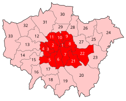
Map of all London boroughs

|
||
| * The City of London has its own status and is not a London Borough.
The 12 boroughs that make up Inner London for administrative purposes are in italics . |
||
The London Boroughs and their administrative affiliations
Inner London
| London Borough | Area in km² |
Residents (June 30, 2013) |
Inhabitants per km² |
Former Metropolitan Boroughs |
|---|---|---|---|---|
| Camden | 21.80 | 229.719 | 10,538 | Hampstead , Holborn , St Pancras |
| Greenwich | 47.35 | 264.008 | 5,576 | Greenwich , most of Woolwich |
| Hackney | 19.06 | 257.379 | 13,504 | Hackney , Shoreditch , Stoke Newington |
| Hammersmith and Fulham | 16.40 | 178,685 | 10,895 | Hammersmith , Fulham |
| Islington | 14.86 | 215,667 | 14,513 | Islington , Finsbury |
| Kensington and Chelsea | 12.13 | 155,594 | 12,827 | Kensington |
| Lambeth | 26.82 | 314,242 | 11,717 | Lambeth (as well as Streatham and Clapham out of Wandsworth ) |
| Lewisham | 35.15 | 286.180 | 8,142 | Lewisham , Deptford |
| Southwark | 28.85 | 298.464 | 10,345 | Bermondsey , Camberwell , Southwark |
| Tower Hamlets | 19.77 | 272,890 | 13,803 | Bethnal Green , Poplar , Stepney |
| Wandsworth | 34.26 | 310,516 | 9,064 | Battersea , Wandsworth (except Streatham and Clapham) |
| Westminster | 21.48 | 226.841 | 10,561 | Paddington , St Marylebone , Westminster |
| Inner London Boroughs | 297.93 | 3,010,185 | 10,104 |
Outer London
City of London
| Surname | Area in km² |
Residents (June 30, 2013) |
Inhabitants per km² |
|---|---|---|---|
| City of London | 2.90 | 7,648 | 2,637 |
Statistical summary
ANNOTATION:
- ↑ a b c Administratively, Greenwich (22) belong to Inner London and Haringey (29) and Newham (27) belong to Outer London. For statistical purposes, Haringey and Newham are included in Inner London and Greenwich in Outer London.
Inner London (administrative)

Inner London (according to census )


- The largest district in terms of area of London is Bromley (20) with ten percent of the total area of London. The City of London (1) is the smallest district with 0.2 percent of the total area.
- Most of the population, 370,000, live in Croydon (19) and the least, 7,600, in the City of London (1).
- The most densely populated is Islington (10) with 14,500 inhabitants per square kilometer and the least populated is Bromley (20) with 2,100 inhabitants per square kilometer. Although the City of London (1) is located in Inner London, it is one of the less densely populated districts with around 2,500 inhabitants per square kilometer. The reason for this difference is to be found in the high density of office and commercial space and "uninhabited" buildings (such as St Paul's Cathedral) in the City of London.
- The 12 boroughs of Inner London cover 19 percent of the area and 36 percent of the population.
- The 20 boroughs of Outer London cover 81 percent of the area and 64 percent of the population.
Web links
- Office for National Statistics ( Memento of June 29, 2011 in the Internet Archive ) with areas of the boroughs of London (PDF file; 1.3 MB)
Individual evidence
- ↑ (Engl.) Duties of London Councils ( Memento of the original September 30, 2014 Internet Archive ) Info: The archive link is automatically inserted and not yet tested. Please check the original and archive link according to the instructions and then remove this notice.
- ^ A b c Population Estimates for UK, England and Wales, Scotland and Northern Ireland, Mid-2013