East of England
| East of England | |
|---|---|
| geography | |
| surface | 19,120 km² |
| Administrative headquarters | Flempton |
| Demographics | |
|
Population population density |
5,907,348 (2012) 309 inhabitants / km² |
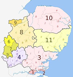
East of England is one of the nine regions of England . The following counties and unitary authorities belong to it :
See also: Administrative division of England
economy
Compared with the GDP of the EU expressed in purchasing power standards, the region achieved an index of 101 (EU-28 = 100) (2015).
Web links
- Government Office for the East of England ( Memento of November 16, 2010 in the Internet Archive )
Individual evidence
- ↑ Population of England and Wales on June 30, 2012 ( ZIP ; 832 kB)
- ↑ Eurostat. Retrieved August 22, 2018 .
Coordinates: 52 ° 15 ' N , 0 ° 33' E


