
Yorkshire and the Humber
| Yorkshire and the Humber | |
|---|---|
  |
|
| geography | |
| surface | 15,420 km² |
| Administrative headquarters | Leeds |
| Demographics | |
|
Population population density |
5,316,691 (2012) 345 inhabitants / km² |
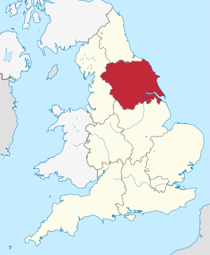
Yorkshire and The Humber is one of the nine regions of England. Its territory covers most of the traditional Yorkshire county , as well as the northern part of Lincolnshire , which was part of the former county of Humberside .
The region is divided into the following counties, unitary authorities, and metropolitan districts:
|
|

The region was originally called Yorkshire and Humberside and consisted of the counties of North Yorkshire , West Yorkshire , South Yorkshire and Humberside . After Humberside was divided, the counties of West and South Yorkshire abolished and York was carved out from North Yorkshire, the present administrative division was created. The old name is still used occasionally today.
See also: Administrative division of England
economy
Compared with the GDP of the EU expressed in purchasing power standards, the region achieved an index of 86 (EU-28 = 100) (2015).
Web links
- Government Office for Yorkshire and the Humber ( July 22, 2010 memento on the Internet Archive )
Individual evidence
- ↑ Population of England and Wales on June 30, 2012 ( ZIP ; 832 kB)
- ↑ Eurostat. Retrieved August 22, 2018 .
Coordinates: 53 ° 34 ′ N , 1 ° 12 ′ W