
Royal Victoria Dock
Coordinates: 51 ° 30 ′ 22.6 " N , 0 ° 1 ′ 41.4" E


The Royal Victoria Dock is the largest of the three harbor basins of the Royal Docks in London's East End and is now part of the Docklands .
history
It opened in 1855 on a previously undeveloped site on the Plaistow Marshes and was the first of the Royal Docks and the first port basin in London designed to accommodate large steamers. It was the first port basin to be equipped with hydraulically operated locks and was the first to have a railway connection (today the North London Line ). It consisted of the large harbor basin and a small entry and exit basin on the west side of the complex, which provided access to the Thames . The harbor basin had four piers, each 152 m long and 43 m wide, on which two-story warehouses were built. Further warehouses, grain silos, sheds and storage buildings were arranged around the harbor basin, which had a quay length of 3.6 km.

The harbor basin was immediately economically successful because it provided berths for all ships with the exception of the very largest steamships. In 1860 it already took an annual tonnage of 850,000 t. on; that was twice as much as that of the London Docks , four times as much as that of the St. Katharine Docks and 70% more than the tonnage of the West India Docks and East India Docks combined. It was badly damaged by German bombs in World War II , but then repaired. From 1960, however, the Royal Victoria Dock - like all London port facilities - recorded a sharp decline in shipping traffic, as shipping relied on container freighters and the berths were therefore relocated downstream to Tilbury . Finally, the Royal Victoria Dock, along with the other Royal Docks, was closed to merchant shipping in 1980.
Destination Docklands

Surprisingly, the French electronic musician Jean Michel Jarre chose the area, which had already been abandoned at the time, in 1988 for one of his mega concerts, which was later called Destination Docklands . The terrain inspired him to write the album Revolutions especially for this event.
The show was intended to show the history of the area, which went from the industrial revolution through the swinging sixties (represented by an appearance by Hank Marvin ) to the later regeneration of the area. This was the biggest concert in the UK, up to then and to this day. A large number of WWII fireworks and searchlights were used; large buildings served as projection surfaces throughout the show. Most of the audience stayed on the wasteland where the ExCeL Exhibition Center is today.
Originally the show was planned as an event to take place on September 24, 1988, but Jarre and his staff kept arguing with Newham Borough Council and the London Fire Department over logistical and safety issues. Although the organizers tried to find other options in the meantime, a compromise was reached by dividing the concert into two events. These concerts took place on October 8th and 9th, 1988. During the construction and the events the weather was very rainy. The first concert took place in almost dry weather, but the second in heavy rain.
The floating stage was built especially for the events and consisted of several barges from northern England, which were welded together to represent Jarre's “warship”. The show had approximately 200,000 viewers excluding those on the television screens that it was watching live on BBC Radio 1 .
During the concert, drawings of the later renovation work on the Royal Docks were shown and some projections on the house facades also dealt with this topic.
A VHS video of the event was made under the direction of Mike Mansfield, but has not yet been released on DVD.
The harbor basin today

The Royal Victoria Dock was significantly rebuilt under the aegis of the London Docklands Development Corporation (LDDC). The harbor basin itself still exists and it is also accessible to ships, but the western approach has been filled in and it is now mainly used for water sports. Its transport links have been significantly improved by roads and the Docklands Light Railway on the north and south sides.
Most of the original warehouses have been demolished, but the historic 19th century K - S and W warehouses have been preserved.
The ExCeL Exhibition Center , which was built on the north side and opened in November 2000, and the neighboring Royal Victoria Dock Bridge now dominate the harbor basin. The ExCeL's waterfront location is a great advantage when hosting the London Boat Show , as the participating ships can anchor along the exhibition center.
Britannia Village is on the south side of the harbor basin . The award-winning residential area with a pedestrian bridge was planned by the LDDC and implemented by Wimpey Homes , the Peabody Trust and the East Thames Housing Group from 1994-2000. Phase 2 of the project is left to the successor organization of the LDDC. It consists of buildings around the pontoon dock with a district center and mixed areas for commercial buildings, shops, leisure facilities and over 700 new residential buildings. It is now in the hands of the London Development Agency (LDA), is called Silvertown Quays and also includes the restoration of the remaining mills on the quays and an aquarium. The Britannia Village has its own administration.
Events
On August 15, 2009, the Great London Swim , a mass swimming event over a distance of 1 mile (1.609 km), took place in this harbor basin .
photos
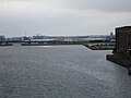
Looking east to London City Airport

View to the south: Several restored buildings, but the Spillers Mills is still in its original condition

Spillers Mills to the south
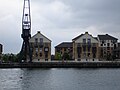
View to the south: Several new buildings and old cranes as a reminder of the past


Web links
- Britannia Village Residents Association
- TV film by London Landscape (6 min.) About the Royal Victoria Dock (English)
- Information about the Royal Docks