
Hamburg-Hammerbrook
|
district of Hamburg |
|
|---|---|
  |
|
| Coordinates | 53 ° 32 '43 " N , 10 ° 1' 50" E |
| surface | 2.5 km² |
| Residents | 4619 (Dec. 31, 2019) |
| Population density | 1848 inhabitants / km² |
| Post Code | 20097, 20537 |
| prefix | 040 |
| district | Hamburg-Mitte district |
| Transport links | |
| Federal road |
|
| Train |
|
| Source: Statistical Office for Hamburg and Schleswig-Holstein | |
Hammerbrook is a district in the Hamburg-Mitte district of the Free and Hanseatic City of Hamburg . The former marsh lowland grew into a densely populated working-class district by the Second World War and was almost completely destroyed in the course of the air raids on Hamburg in 1943 . After the war initially kept free as commercial reserve space, Hammerbrook was expanded into an office location from the 1980s under the name City Süd . For some years now, more and more apartments have been built.
geography
Hammerbrook is bounded to the north by the railway line to Berlin and Lübeck, where it borders on St. Georg . In the west, Hammerbrook meets the Hamburg-Altstadt district on Deichtorplatz ; in the southwest and south, Oberhafenkanal and Bille mark the border with HafenCity and Rothenburgsort . The border to Borgfelde runs along the Mittelkanal in the northeast and the border to Hamm on Grevenweg in the east .
Scenic is Hammerbrook a marshland in the area of Bille mouth in the North Elbe , which was originally used for grazing and until the 18th century repeated by storm surges was flooded. From the 1840s onwards, it was drained through several canals, raised several meters and then densely built up.
history


"Hammer Brook" originally referred to the entire marshland from the Oberhafen to Horn , which was bordered in the north by the Geesthang and in the south by the Bille. The name refers to the earlier affiliation of the area to the village or today's district of Hamm . Brook refers to a deep, humid and swampy quarry land .
Hamburg acquired this area from the Holstein counts in 1383 ; from 1410 it belonged to the land lordship of Hamm and Horn , which was administered by a Hamburg councilor. The area was mainly used as pasture for cattle, which - in order to reduce the constant flooding - was gradually diked and crossed with drainage ditches . Today's flood basin , which stretches from Anckelmannplatz to the Bille, was created in the 17th century as part of Hamburg's city fortifications under the name Retranchementgraben .
The settlement of Hammerbrook began - advancing from the west and initially along the dikes (Stadtdeich, Grüner Deich, Bullerdeich, Hammer Deich) - towards the end of the 17th century. However, the Brook was only settled according to plan after the Hamburg fire in 1842 through the construction of a grid-shaped network of canals and streets. The development project was promoted by Senate Syndicate Wilhelm Amsinck and the English engineer William Lindley .
As early as 1832, the western (inner) part of the Hammerbrook up to the flood basin was included in the newly formed suburb of St. Georg , the eastern (outer) part initially came under the rule of the Geestlande and was divided into the suburbs of Borgfelde and Hamm in 1871 . The construction of the Hamburg-Bergedorfer Railway (1842), the Hamburg-Lübeck Railway of the LBE (1865) and the Hamburg-Altona connecting railway with the Berliner Tor station (1906) and the abolition of the gate barrier (1860) promoted dense settlement. In 1867 there were 10,000 people living on Hammerbrook, in 1910 there were already over 60,000. The population growth was due in particular to the relocation from the former Gängeviertel in the area of today's Kontorhausviertel as well as from the free port ( Speicherstadt ) established in 1888 , as the Hammerbrook guaranteed affordable accommodation due to its proximity to the workplace.

In the township elections in 1901, Otto Stolten won the Hammerbrook constituency and was the first social democrat to join the Hamburg parliament . In 1919 he became second mayor of Hamburg.
After the completion of the drainage measures in 1909, in the course of which the area was raised by more than five meters in some cases with sand from the Boberger dunes , the intensive development began with large blocks of houses, many of which were slotted structures . The numerous canals served on the one hand for drainage and on the other hand as inexpensive transport routes for the settling companies. In the course of the reorganization of the urban area according to the Greater Hamburg Act , today's Hammerbrook district was formed in 1938; only the easternmost part of the Brooks (Osterbrook) remained at Hamm-Süd .
During the Second World War , Hammerbrook was almost completely destroyed by British and US bombers on the night of July 27th to 28th, 1943 , the wildfires that triggered a firestorm in which around 12,000 people died. From mid-1944, around 35 concentration camp prisoners were housed in an elementary school on Brackdamm, whose task it was to search for and defuse bomb blind people. From October 1944, the Hammerbrook subcamp with around 2,000 prisoners of different nationalities was housed on seven floors in the rear building of an office complex at Spaldingstrasse 156/158 .
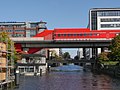
After the war, only a few hundred people lived in Hammerbrook. Due to the lack of population, the heavily damaged elevated railway line to Rothenburgsort with the Spaldingstraße and Süderstraße stations was not rebuilt and removed along with the other rubble. Several canals were filled with rubble, including the north canal, which today is called the north canal road and relieves the Spalding road that runs parallel to it. The areas freed from the rubble were kept free for a long time as commercial reserve area and only opened up again after the construction of the S-Bahn line to Harburg .
In 2008, as part of a regional reform, parts of the disbanded Klostertor district came to Hammerbrook, including the Münzviertel and the wholesale market area at the Oberhafen.
statistics
- Minor quota: 11.4% [Hamburg average: 16.3% (2017)].
- Elderly rate: 3.4% [Hamburg average: 18.2% (2017)].
- Proportion of foreigners: 46.0% [Hamburg average: 17.1% (2017)].
- Unemployment rate: 7.3% [Hamburg average: 5.2% (2017)].
The average income per taxpayer in Hammerbrook is 19,468 euros annually (2013), the Hamburg average is 39,054 euros.
politics
For the election to the citizenry and the district assembly , Hammerbrook belongs to the constituency of Hamburg-Mitte . The 2015 state election led to the following result:
- SPD : 26.3% (−9.1)
- Greens : 22.2% (-0.3)
- Left : 21.3% (+6.3)
- CDU : 7.3% (−2.0)
- Pirates : 6.7% (−2.7)
- Party : 6.0% (+1.4)
- AfD : 4.2% (+4.2)
- FDP : 3.4% (+1.0)
- Others: 2.6% (+1.2)
Culture and sights
Buildings
Due to the extensive destruction in World War II, only a few significant buildings from the pre-war period have survived. This includes, for example, the Leder-Schüler office building .
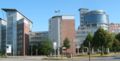
Today modern office buildings predominate in the district. It is worth mentioning u. a. the Berliner Bogen , which with 14,000 square meters of glass is considered to be the largest glass building on the European continent. The Hammerbrook S-Bahn station (opened in 1983/84) is also architecturally significant, and its “futuristic” appearance caused a sensation when it was built.

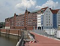
The canals of the Hammerbrook are connected to the Oberhafen by a lock

Residential building on Nagelsweg
Poseidonhof building ensemble
Fruchthof at the Oberhafen

Kontorhaus "Sonninhof", formerly the central warehouse and confectionery factory of GEG


Economy and Infrastructure

After the almost complete destruction in the Second World War, the area of the district was kept free in the development plan for industrial settlement. Because of the good transport infrastructure (canals, railway siding and the proximity of the Elbe bridges with their motorway access ), it was hoped that there would be strong demand, but this did not materialize.
However, the development plan could not prevent a number of administrative buildings from being built over the course of several decades. From the end of the 1980s onwards, the City Süd was successfully promoted to attract additional administrations. Due to its central location, Hammerbrook has recently come back into focus for a mixed urban revival with a higher proportion of apartments.
traffic
Three main roads with heavy traffic lead through the quarter, on the one hand the parallel Spaldingstrasse and Nordkanalstrasse (formerly B 5 ) as the main connection to the east, and also the Amsinckstrasse ( B 4 ) and the Heidenkampsweg ( B 75 ) as a feeder to the Elbe bridges and the motorway ( A 1 / A 255 ).
The S-Bahn Hamburg has here on the Harburg S-Bahn route the Hamburg-Hammerbrook station (lines S 3 and S 31). The station building, which was modeled on a fast-moving train, was built from 1978 to 1983 according to plans by the Schramm, Pempelfort, von Bassewitz and Hupertz architects.
Hammerbrook S-Bahn station

platform
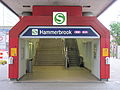
entrance


Established businesses
Several public companies have their headquarters in Hammerbrook, including the State Office for Roads, Bridges and Waters (Sachsenfeld), the State Office for Transport (Ausschläger Weg), the S-Bahn Hamburg (Hammerbrookstraße) and the Hamburg city cleaning service (Bullerdeich).
With National Starch and Chemical , one of the leading manufacturers of industrial and food starch is based in the south of Hammerbrook. The DAK health has its headquarters in Hammerbrook. The companies Sun Microsystems GmbH and Star Finanz GmbH are also located here.
The record company Mental Madness Records , with producing musicians like Brooklyn Bounce or Special D. , is based on Brackdamm.
education
The private education provider Stiftung Grone-Schule has its headquarters and a large part of its training rooms on the Mittelkanal in Heinrich-Grone-Stieg and in Gotenstrasse . The state commercial school with business school is located on Wendenstrasse . The state distance university in Hagen maintains its regional center in Hamburg on Amsinckstrasse . The Euro Akademie Hamburg (until 2014: Hamburg Foreign Language and Business School ) is also based in Hammerbrook.
See also
- List of streets, squares and bridges in Hamburg-Hammerbrook
- List of cultural monuments in Hamburg-Hammerbrook
- List of stumbling blocks in Hamburg-Hammerbrook
literature
- Gundula Buchner: From marshland to commercial and residential area: William Linley's plan for the expansion of the 'Hammerbrook' and its realization from the middle to the end of the 19th century. University of Hamburg, diploma thesis FB 05, WS 1982/83
- Ursula Meyer-Rogge: glacial valley. Hammerbrook , Verlag Sautter + Lackmann, Hamburg 2016, ISBN 978-3-88920-074-7
- Anne-Marie Thede-Ottowell: From the old city dike (between the wholesale market halls and Hammerbrook), Hamm district archive, Hamburg, ISBN 3-9803705-6-9 .
- We have always helped each other - memories of Hammerbrook , Hamm district archive, Volume 8, Hamburg 1997, ISBN 3-9803705-5-0
- Rainer Ahlers: Sankt Georg Buch - with Borgfelde, Hohenfelde, Hammerbrook and Hamm . Junius-Verlag, Hamburg 2015, ISBN 978-3-88506-059-8 .
Web links
Individual evidence
- ^ Horst Beckershaus: The names of the Hamburg districts. Where do they come from and what they mean , Hamburg 2002, ISBN 3-434-52545-9 , p. 51.
- ↑ Map of the destruction in 1945
- ↑ Quota of minors in the Hamburg districts in 2017
- ↑ Proportion of 65-year-olds and older in the Hamburg districts in 2017
- ↑ Proportion of foreigners in the Hamburg districts in 2017
- ↑ Unemployment rate in the Hamburg districts in 2017
- ↑ Statistical Office for Hamburg and Schleswig-Holstein (ed.): Hamburg District Profile 2016 (= NORD.regional . Volume 19 ). 2018, ISSN 1863-9518 ( Online PDF 6.6 MB [accessed February 12, 2018]).
- ↑ http://www.wahlen-hamburg.de/wahlen.php?site=left/gebiete&wahltyp=3#index.php?site=right/result&wahl=973&gebiet=36&typ=4&stimme=1&gID=4&gTyp=2
- ^ Schröter in: Hamburg's train stations in change . Medien-Verlag Schubert, Hamburg 1994.
- ↑ Hammerbrook: 750 apartments around a park ( Memento from October 4, 2015 in the Internet Archive ), NDR , October 1, 2015
- ^ Housing construction: New life on the canal in Hammerbrook , Hamburger Abendblatt , October 19, 2012
Billbrook | Billstedt | Borgfelde | Finkenwerder | HafenCity | Hamburg old town | Hamm | Hammerbrook | Horn | Little Grasbrook | Neustadt | Neuwerk | Rothenburgsort | Steinwerder | St. George | St. Pauli | Veddel | Waltershof | Wilhelmsburg