Carpinteria
| Carpinteria | ||
|---|---|---|
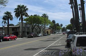
 Linden Avenue (facing the ocean) |
||
| Location in California | ||
|
|
||
| Basic data | ||
| Foundation : | September 28, 1965 | |
| State : | United States | |
| State : | California | |
| County : | Santa Barbara County | |
| Coordinates : | 34 ° 24 ′ N , 119 ° 31 ′ W | |
| Time zone : | Pacific ( UTC − 8 / −7 ) | |
| Residents : | 14,194 (as of: 2000) | |
| Population density : | 2,027.7 inhabitants per km 2 | |
| Area : | 18.8 km 2 (approx. 7 mi 2 ) of which 7.0 km 2 (approx. 3 mi 2 ) are land |
|
| Height : | 10 m | |
| Postcodes : | 93013, 93014 | |
| Area code : | +1 805 | |
| FIPS : | 06-11446 | |
| GNIS ID : | 1652684 | |
| Website : | www.carpinteria.ca.us | |
Carpinteria is a city in Santa Barbara County in the US state of California , United States , with 14,000 inhabitants (as of 2004). It is right on the Pacific Ocean .
The metropolitan area has an area of 18.8 km² and is 12 miles south of Santa Barbara . It has a rail and a highway connection US Highway 101 .
Carpinteria is home to the Pacifica Graduate Institute , a private university. The weekly newspaper The Coastal View is published locally . The California Avocado Festival has been held here every October since 1987. The Carpinteria Valley Museum of History is located on Maple Avenue.
The Chumash Indian tribe lived in the Carpinteria area and built wooden canoes on the coast , which they then sealed with the tar naturally occurring in the area. This workshop is said to have led to the Spanish name Carpinteria (German "carpentry").
