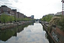
Hammerbrooker Canals
The Hammerbrooker canals are a network of navigable canals in the Hamburg districts of Hammerbrook and Hamm . They were laid out in the course of the development of Hammerbrooks in the years 1842–1847 according to a plan by William Lindley and extended further east from the 1880s. They served, on the one hand, to drain the low-lying marshland and, on the other, as transport routes to the new residential and commercial areas. After the extensive destruction of Hammerbrooks in World War II , part of the canals was filled with rubble and built over. The remaining canals are entered in the Hamburg monument list under ID 44134 .
history
Hammerbrook has belonged to the Hamburg countryside since the 14th century , but for a long time, due to its location and nature, it could be used almost exclusively as pasture. The sparse development was concentrated on a strip on the Geest slope and the dykes (Stadtdeich, Grüner Deich, Hammer Deich), while the low-lying hinterland was often under water for weeks or months despite dikes after storm surges or Elbe floods .

During the construction of the Hamburg-Bergedorfer Railway (1838–1842), Lindley had therefore already dealt with the question of the permanent drainage of the building site and at the end of 1840 submitted a proposal to the Hamburg Senate to "improve Hammerbrooks". His plan envisaged expanding the existing drainage ditches ( wetter ) into an efficient sewer network and raising the remaining area to a flood-safe level with the excavation . The new canals should be navigable as access routes for barges and smaller ships and at the same time serve as intermediate storage for the collected ground and surface water, which, depending on the water level of the Elbe , should then flow into the Bille or the Elbe or be pumped with steam engines .
To finance and implement the project, Lindley won a consortium of Hamburg merchants who were also involved in the construction of the railway to Bergedorf, including August Abendroth , Justus Ruperti and Heinrich Christian Meyer . The Hammerbrook-Landunternehmung they founded systematically bought up land in order to later sell it on as building land and to take over part of the construction costs from the expected profit. The project received political support primarily from Senator Spalding and the two Senate syndicates Eduard Banks and Wilhelm Amsinck , after whom several main streets in the district are named. On September 1, 1842, the council and the citizenship approved the project by a joint resolution. Months earlier, the great city fire had destroyed around a third of Hamburg's inner city and thus significantly increased the need for new apartments, at the same time the rubble could be used to raise Hammerbrook.
Lindley's canal project was implemented by the late 1840s; In 1847 the Hammerbrook lock was completed, which has since connected the network with the Oberhafen and the Elbe. The Hammerbrook was only settled across the board after the blocking gate barrier was lifted at the turn of the year 1860/61. The area west of the flood basin was completely built up by around 1880. Around the same time, the decision was made to build the Speicherstadt , for which the previous residential areas on the Elbe islands of Kehrwieder and Wandrahm had to be demolished and around 20,000 people relocated. The majority of them found a new home on Hammerbrook, which from 1900 was also raised several meters east of the flood basin with sand from the Boberger dunes and densely built with tenement houses. For this purpose, the central and southern canals were extended to the east to the border of the Horner Marsch.
Overview of the channels
The table lists the channels still available today on a light background and the no longer available on a dark background. Historical information is in brackets.
literature
- Martin Kinzinger: William Lindley's plans for the development of Hammerbrooks - city expansion in Hamburg around 1842 as a contribution to business promotion . In: Ortwin Pelc , Susanne Grötz (ed.): Constructor of the modern city: William Lindley in Hamburg and Europe 1808–1900. Dölling and Galitz 2008, ISBN 978-3-937904-77-1 , pp. 192-221.
Individual evidence
- ↑ List of monuments. Retrieved July 5, 2020 .
- ↑ Kintzinger p. 197.
- ↑ Kintzinger p. 198.
- ↑ William Lindley : Report of the engineer W. Lindley, the improvement of the Hammerbrooks concerning: with floor plan ( digitalisat ), 1840
- ↑ Kintzinger p. 202.
- ↑ On this official measurement table from 1895 , the two canals already extend as far as Borstelmannsweg, according to this plan from 1913 apparently even further construction was planned as far as the Horner Marsch, which was never implemented.


