
South Canal (Hamburg-Hammerbrook)
| South channel | |||||||||||||||||||||||||||||||||||||||||||||||||||||
|---|---|---|---|---|---|---|---|---|---|---|---|---|---|---|---|---|---|---|---|---|---|---|---|---|---|---|---|---|---|---|---|---|---|---|---|---|---|---|---|---|---|---|---|---|---|---|---|---|---|---|---|---|---|
| location | Hamburg-Hammerbrook , Hamburg-Hamm | ||||||||||||||||||||||||||||||||||||||||||||||||||||
| length | 2.58 km | ||||||||||||||||||||||||||||||||||||||||||||||||||||
| Beginning | Bille | ||||||||||||||||||||||||||||||||||||||||||||||||||||
| The End | Hammerbrookstrasse | ||||||||||||||||||||||||||||||||||||||||||||||||||||
| Junctions, crossings | Flood basin | ||||||||||||||||||||||||||||||||||||||||||||||||||||
| Used river | Bille | ||||||||||||||||||||||||||||||||||||||||||||||||||||
 |
|||||||||||||||||||||||||||||||||||||||||||||||||||||
|
course
|
|||||||||||||||||||||||||||||||||||||||||||||||||||||
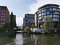
The Südkanal is a canal in the Hamburg districts of Hammerbrook and Hamm , which opens up the surrounding industrial and port areas. According to the Hamburg Water Act, it is classified as a first-order body of water. The canal got its name because it is located in the south of Hammerbrook (south of the Nordkanal and Mittelkanal ). The northern canal was filled in after the Second World War and built over with today's northern canal road.
The southern canal was built after the Hamburg fire of 1842 according to plans by William Lindley and was part of a comprehensive canal project to develop the Hammerbrooks. Originally it only reached as far as the flood basin, but after 1880 it was extended further east along with the central canal.
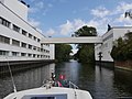
The passage over the Mittelkanal to the Oberhafen and the Elbe over the Hammerbrook lock is currently (2019) not possible due to construction work, but there is a transition over the flood basin and over the Bille and thus over the Tiefstackschleuse or the Brandshofer lock to the Elbe.
Third Heidenkamp bridge and flood basin

Railway bridge over the southern canal
Factory premises Tchibo with bridge


.jpg)
Individual evidence
- ↑ Hamburg Water Act (HWaG) , Hamburg, December 14, 2007
Web links
Coordinates: 53 ° 32 ′ 57 ″ N , 10 ° 2 ′ 41 ″ E