
Alster

|
Tributaries and hydraulic structures
|
|||||||||||||||||||||||||||||||||||||||||||||||||||||||||||||||||||||||||||||||||||||||||||||||||||||||||||||||||||||||||||||||||||||||||||||||||||||||||||||||||||||||||||||||||||||||||||||||||||||||||||||||||||||||||||||||||||||||||||||||||||||||||||||||||||||||||||||||||||||||||||||||||||||||||||||||||||||||||||||||||||||||||||||||||||||||||||||||||||||||||||||||||||||||||||||||||||||||||||||||||||||
The Alster is a 56 km long tributary of the Elbe and flows through southern Holstein and Hamburg . The best-known and most striking part of the Alster is the Alster Lake, which is formed in the inner-city area of Hamburg by the Inner and Outer Alster . The development around the Inner Alster is often characterized by white facades and copper-clad roofs of Wilhelminian-style office and commercial buildings.
Surname
The water is called Alstra in the oldest document from the end of the 11th century . In the following years there are different spellings in the documents; Alster appears for the first time in the 15th century. The name is based on an Indo-European root meaning "waters", "river".
course
Alster

The Alster rises in the area of the municipality of Henstedt-Ulzburg . Their source is in the north of the Henstedt-Rhen district . From there, the sometimes strongly meandering river initially runs north and bends a few hundred meters further downstream to the east. After passing Wakendorf II and coming from the north Ronne at the level of the peasantry Middle Furth and passing under the B 432 (south of close ) eventually turns the Alster River to the south. The Alster flows through or touches - mainly in a southerly direction - the areas of Bargfeld-Stegen , where the Alte Alster coming from the northeast joins at Gut Stegen , Kayhude (here the Alsterwanderweg begins ) and Tangstedt-Rade . Shortly before the Rader lock , the Sielbek coming from the east joins the Alster.
The Oberalster lowland between Wakendorf II in the Segeberg district and Tangstedt in the Stormarn district emerged from the siltation of a shallow ice reservoir formed during the Glacial Vistula . The Upper Alster was canalized in the 15th century during the construction of the Alster-Beste Canal (also: Alster-Trave Canal ) to create a direct waterway between Hamburg and Lübeck .
Shortly after passing Wulksfelder Schleuse and Gut Wulksfelde, the Alster reaches the Hamburg urban area, namely the districts of Duvenstedt and Wohldorf-Ohlstedt . The Ammersbek coming from the east joins the Wohldorfer lock . The river then winds through the terminal moraine landscape of the Alstertal . As far as the Mellingburg lock in Lemsahl-Mellingstedt , the Drosselbek , Bredenbek , Rodenbek , Horstbek and Saselbek flow into several nature reserves . In Poppenbüttel there is a weir at the level of the former Poppenbüttler lock and Henneberg Castle . The Alster then reaches Wellingsbüttel and flows past the Wellingsbüttel manor . In Ohlsdorf, it reaches a weir at the level of the former Fuhlsbüttler lock as the last water level regulator before the Outer Alster, which is further downstream.
Streek
The Alster section from Ohlsdorf to the confluence with the Outer Alster is sometimes referred to as the Streek (Low German for area) or Alsterstreek. The course has been artificially straightened in this section of the river. The old course of the river led through the Ring Canal , the Braband Canal and the towpath canal . In parallel, the Skagerrak Canal and the Island Canal lead south.
After the construction of the Fuhlsbüttler lock (1913, demolished in 2011, then replaced by a weir), Fritz Schumacher presented a concept for channeling the Alster below the lock to Eppendorf. His concept envisaged a strictly architectural setting with embankment walls, terraces and pools. The engineering of the city of Hamburg, however, preferred a natural version of the Alster river. The opposing designs were controversial, Schumacher's approach was well received, and finally his ideas were partially implemented. The Tarpenbek flows into Eppendorf and the Isebek Canal on the border with Harvestehude . The Krugkoppelbrücke finally forms the border to the Outer Alster .
Alster Lake
The Alster Lake was created in 1190 under Count Adolf III. by damming the river with a dam to serve as a mill pond for operating a large grain mill. Large areas of the uninhabited Alster meadows were flooded. After the later tenant Reese, the dam was named Reesedamm , from which, after further widening, became today's Jungfernstieg . It was not until 1616 to 1625 that the mill pond was separated into the outer and inner Alster with the construction of the Hamburg ramparts . The flow of the Alster was given a wooden bridge with a floating tree trunk secured by chains as a barrier. At this point, later became the Lombard bridge and north of it in 1953, the New Lombardsbrücke , current Kennedy bridge built.
Outer Alster

The Outer Alster , which is around 164 hectares in size and up to 4.5 meters deep, is the larger, northern part of the Alster Lake. It is fed by the Alster in the north and the Osterbek and Wandse in the east. It flows in the south into the Inner Alster.
The Alsterpark is laid out around the Outer Alster , the western part of which was expanded at the same time as the International Horticultural Exhibition (IGA) in 1953. Here you have - with a few exceptions - a clear view of the Alster. This is particularly attractive with the annual large fireworks on the occasion of the cherry blossom festival of the Japanese community in Hamburg. This fireworks display took place for the first time in 1968 to commemorate the planting of around 5000 cherry trees in the city, donated by Japanese companies based in the Hanseatic city.
Around this reservoir there are footpaths and bike paths that are very popular with Hamburg residents for recreation and jogging . The path, which is almost continuously located directly on the bank, has been marked with half-kilometer stones for joggers and runners and is 7.4 kilometers long. The Outer Alster itself is mainly used for sailing and rowing as well as for pedal boating and stand-up paddling. As a sailing area, it is considered to be not that easy, as the frequently changing wind conditions due to the peripheral buildings and the confluent streets require a certain skill on the part of the sailors - in addition, here on the water basically " right before left " applies ( except for the Alster steamers, commercial shipping always has priority).
Some of Hamburg's most sought-after residential areas are located on the Outer Alster , including Harvestehude in the west and the streets Bellevue ( Winterhude ) and Schöne Aussicht ( Uhlenhorst ) in the northeast. The well-known Hotel Atlantic ( St. Georg ) is also located here on the south-eastern bank.
The Lombard Bridge marks the old course of the city fortifications that separates the Outer Alster from the Inner Alster. Since this bridge could no longer handle the traffic alone, the New Lombard Bridge was added as early as 1953 north of the old crossing , which was renamed the Kennedy Bridge in 1963 in honor of John F. Kennedy after his murder . The 10 ° meridian is marked in the pavement on your walkway (north side) .
The two bridges are of great importance for inner-city vehicle traffic as well as for local and long-distance rail traffic ( Hamburg-Altona connection line ). The Alster divides the city into east and west and poses a problem for local transport. There were already several plans for major transport projects that were to cross under the Outer Alster in a tunnel. In the 1920s they wanted to build an underground line ( Alsterhalbring ) between Hallerstrasse and Mundsburg . In the post-war period, as part of far-reaching road projects, the realization of an expressway tunnel to the north bypass of the inner city and the Alster bridges was considered.
Inner Alster
The Inner Alster , which has an area of around 18 hectares , is the smaller, southern part of the Alster Lake. It is fed by the Outer Alster in the northeast and flows in the southern corner below the Jungfernstieg over the Kleine Alster towards the Elbe . With only a few exceptions, private motor ship traffic is not permitted on the Inner Alster.
Anchored on a floating pontoon in the middle of the Inner Alster, the Alster fountain ( financed by private patrons ) spouting up to 60 meters in height has been located since 1987 . The associated introduction of atmospheric oxygen has now contributed to a recognized significant improvement in water quality . During the Christmas season, this fountain will be replaced by an illuminated Christmas tree and will then no longer be operated in the remaining winter months.
There are various commercial buildings around the Inner Alster, including the headquarters of Hapag-Lloyd AG , the Hotel Vier Jahreszeiten , the traditional Alsterhaus department store and the no less famous Alster pavilion . The latest attraction since autumn 2006 is the not undisputed Europa Passage .
On the southwestern shore, the Jungfernstieg, which is the main pier for the "White Fleet" of Alster steamer (excursion boats), from here both the Alster with its canals and the Hamburg canals busy and at times up to Bergedorf run. There is access to the Jungfernstieg underground and S-Bahn station directly at the landing stage . The station facilities of the City-S-Bahn lines S1 , S2 and S3 and the underground lines U2 and U4 are located crosswise on several floors under the Inner Alster and Kleine Alster, while those of the older U1 under the eponymous Jungfernstieg.
For construction around the Inner Alster - the "parlor Hamburg's" so-called - made with the Inner Alster Regulation strict building codes designed to ensure among other things that the view from the Lombard bridge the panorama with the towers of the five hamburgers main churches ( Michel , St. Nikolai , St. Petri , St. Katharinen and St. Jacobi ) and the tower of the town hall is not affected. In addition, it is stipulated that the roofs of the adjacent buildings are copper-clad because of the desired verdigris formation as a contrast to the light-colored facades ; furthermore, facade advertising is not permitted.
Every year on a long weekend at the end of August, the Alster fun took place around the Inner Alster from 1976 to 2018 on the immediately adjacent streets. A particular highlight since 1994 has been the international fireworks festival, held over three evenings, initiated and moderated by Carlheinz Hollmann until his death .

Small Alster
The Kleine Alster in Hamburg's city center is now just a 200-meter-long and 40-meter-wide section of the river that connects the Inner Alster with the Alsterfleet . At this point the Alster is dammed by the town hall lock. The Kleine Alster is limited:
- from the Alster arcades on the northwest side ( Hamburg-Neustadt ),
- the Reesendamm on the opposite bank ( Hamburg-Altstadt ), where a wide staircase leads down to a promenade with mooring for boats,
- from the Reesendamm bridge to the Inner Alster,
- from the lock bridge with the town hall lock below to the Alsterfleet .
After the completion of the Jungfernstieg underground and suburban railway junction , the town hall lock above it was renewed and inaugurated in 1975.
The Hamburg Memorial (Barlach stele) for the fallen of the First World War, inaugurated in 1931, stands at the Schleusenbrücke with the relief Mourning Mother and Child by Ernst Barlach , which admonishes against war. During the Nazi era, the relief was removed as degenerate art , and in 1949 it was reconstructed.
In summer, the Kleine Alster is the meeting point for many tourists who can feed the Alster swans there. For the duration of the winter months, these are relocated to the Eppendorfer mill pond and looked after by the " swan father ".
The Kleine Alster, together with the town hall market and town hall, forms an urban ensemble that is based on St. Mark's Square in Venice and is generally regarded as particularly successful. It was designed after the great fire of 1842 by the architect Alexis de Chateauneuf , who also designed the Alster arcades and the lock bridge at that time.
Because of the low height of the bridges, the Kleine Alster cannot be used by large ships. Part of the Alster fleet is therefore dimensioned so that its ships can reach the Elbe and Bille sailing areas via the Kleine Alster .
Alsterfleet
The Alsterfleet begins today at the lock bridge, under which the modern town hall lock is operated, and flows into the inland port at the southern end at Steinhöft, not far from baumall . In the past, the Kleine Alster bordered directly as far as the Mönkedammfleet , before the following section of the river was called the Alsterfleet.
From the Alsterfleet a branch canal leads to the right to the Bleichenfleet, the extension of which from the Stadthausbrücke is called Herrengrabenfleet and flows into the Elbe at the Baumwall.
To the left along and partly under the elevated railway line that Mönkedammfleet branches, located (the building of the road from the Big Burstah / Mühlenbrücke Hamburger Sparkasse overbuilt) as Nicolaifleet continue and was formerly Hauptmündungsarm the Alster. Like the Alsterfleet, the Nicolaifleet flows into the inland port.
The Schaartor lock in front of the current confluence of the Alsterfleet into the Elbe was only created after the storm surge in 1962 to protect Hamburg's inner city . Powerful pumps are installed here so that the Alster can also be drained when the Elbe floods .
Recreational use

The Alster can be traveled all year round with canoes and kayaks from the Rader Schleuse . The stretch north of the Fuhlsbüttler weir is not suitable for rowing boats, except in the reservoir area of the Poppenbüttler weir. Motorboats are only permitted on the Alster between Quelle and Kleiner Alster with a special permit. The stretch to the weir in Duvenstedt is partly overgrown by bushes and trees, which makes it difficult to get through by boat. Below the Poppenbüttler weir, the Alster becomes so flat in some places during prolonged drought that even canoes and kayaks run aground and have to be pulled.
You can go on the Outer and Inner Alster with Alster ships , rowing and sailing boats . There are several boat rentals for canoes and kayaks between Poppenbüttel and the Outer Alster, and rowing and sailing boats can be rented on the Outer Alster. Several rowing and sailing clubs are located on both sides of the Outer Alster, such as the traditional clubs Der Hamburger and Germania Ruder Club and the Norddeutsche Regatta Verein . The curved shape of the Outer Alster, however, does not permit a suitable rowing regatta course over 2000 m, so that only the less attractive length of 1500 m with the required width is possible here.
On the occasion of “800 Years of the Port of Hamburg”, the first dragon boat race was held in Hamburg on the Alster in 1989 .
Until the 1920s, there was a public bathing establishment on Schwanenwik and in the southwest corner of the Outer Alster. In May 2006, the Hamburg citizenship decided that there should be a beach and an open-air swimming pool again at Schwanenwik . However, these plans were rejected again, because despite new transport chutes and mixed water retention basins, which prevent wastewater from entering the Alster after heavy rainfall , the Alster only has bathing water quality in dry weather . However, the Inner Alster has been the venue for the first triathlon swimming discipline since 2002 .
In cold winters, the Outer Alster freezes so much that the ice can be stepped on and is also used for ice and winter sports. If there is heavy ice formation, stalls and stands that mostly offer warm drinks such as mulled wine or a snack may be set up. This so-called Alster ice pleasure took place in 1979, 1985, 1991, 1996, 1997 and 2012, for example. After the ice fun in 1997 with a million visitors, a smaller version of the festival took place in winter 2010 without opening the Alster. During the ice fun in 2012, the stalls were on the banks of the Alster. Even in 1982, 1986 and 1987 - without official approval - thousands of people were on the frozen Alster.
Alster round

Outer and Inner Alster are almost completely lined with public roads; except for a few hundred meters on the south side of the Long Train. The route around the Outer Alster is 7.33 km long (with the Inner Alster approx. 10 km) and is one of the most popular running laps in Europe. On fine days, 10,000 runners circle the Outer Alster.
A measuring system for runners has been permanently installed on the Alster circuit since July 2012. The transit time can be measured and evaluated on six measuring columns with the help of a transponder chip .
Fish fauna and fisheries
In parts of the Inner Alster, the Outer Alster, the Alster from the Fuhlsbüttler Wehr to the Outer Alster as well as the canals that flow into the Alster, holders of the annual fishing license may fish without a permit (so-called free waters). The fishing rights are leased above the Fuhlsbüttler weir.
The ASVHH (Angelsport-Verband Hamburg) fills the Alster every year with carp. Specimens weighing 15 kg have already been caught. The spectrum of fish species ranges from eel to pikeperch . From a water-ecological point of view, the Alster shows very different areas, these range from the tidal Nicolaifleet, the dammed Aussenalster and its canal network to the flowing Alster above the Fuhlsbüttler lock, with characteristic fish species. There are brackish water species such as ruddy perch and flounder, still water species such as tench and rudd and flowing water species such as Mühlkoppe, Aland, gudgeon, brown trout and the round mouthed river lamprey. In addition, there are bream, bream, roach, perch, pike and pikeperch.
cleanliness

In the past, the Alster had a relatively good water quality, despite its heavy use as a recreational body of water. However, in some places there is a lot of debris on and under the water surface. It is therefore not recommended to go swimming here - also because of the risk of colliding with a boat. The water quality has now largely decreased. In addition to numerous other parameters, the ecological status of the invertebrate fauna of the Alster is classified as unsatisfactory or poor. In summer 2018 there was an increased bloom of blue algae.
history
The city of Hamburg gradually bought the Alster with all rights, freedoms, uses and property: In the first step, Count Adolf V von Holstein-Segeberg sold a quarter of the river for 250 marks . Another quarter was sold on February 22nd, 1309 by Count Johann II von Holstein-Kiel for 200 marks. On January 1, 1310, Count Adolf VI. von Holstein bought the remaining half of the Alster from the city of Hamburg for 600 marks pfennigs and reserved the right of repurchase for 36 years.
There was a dispute with Denmark for centuries because the old Alster dried up after the unsuccessful construction of the Alster-Beste Canal and the new source river became the Henstedter Alster. However, the city of Hamburg never acquired rights to this tributary of the Alster. It was not until 1768 that Hamburg regained the rights to the entire Alster.
The special rights of the city of Hamburg on the Alster outside the city area ended on April 1, 1937
The Alster used to be navigable as far as Stegen (Alster kilometer 16.5), which is now part of the municipality of Bargfeld-Stegen in Schleswig-Holstein. There was a connection to the Alster-Beste canal there for the years 1529 to 1550 . Up until the 1970s, the Alster was an important traffic route for freight transport within Hamburg and to the northern suburbs. The goods were transported from the port area with barges over the canals to the Inner and Outer Alster. The Alster and its canals (such as the Osterbek Canal ) were also of considerable importance for local public transport . Until 1984, the Alster ships operated as a regular means of transport in the Hamburg Transport Association on the Inner and Outer Alster . Today the Alster steamers mainly make round trips. In the summer months, however, the museum line to the Museum of Labor in Barmbek-Nord also runs . The oldest surviving Alster ship is the St. Georg . Before the Second World War there were shipping lines to Ohlsdorf and to Stadtparksee in Winterhude .
Although the Alster was used intensively for traffic, there used to be swimming pools on the bank. In the 1920s and 30s there was a large bathing establishment on Schwanenwik.
During the Second World War, the Inner Alster was given a camouflage cover. The inner city backdrop, built almost entirely of wood, was intended to make orientation difficult for approaching bomber units. In the Outer Alster there was a “false” Lombard bridge and an anti-aircraft position.
photos

Canalized Alster near Alsterdorf

Alster (river), view from the Krugkoppelbrücke in northern direction, oak park on the left, towpath on the right

Alster (river) at the oak park

Views around the Outer and Inner Alster

View from the Alsterarkaden over the Kleine Alster towards

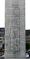
Floating figure on the Outer Alster by Stephan Balkenhol

Inner and Outer Alster with the Lombard and Kennedy Bridge

Sailing regatta on the Outer Alster
Ernst Barlach: grieving mother with child

Outer Alster from the air (facing southeast)

Inner Alster on Jungfernstieg

View of the Jungfernstieg
Inner Alster with the Alster steamer St. Georg built in 1876

The Kleine Alster towards the Inner Alster , on the left the Alster arcades . The stairs in front lead to the memorial.

The town hall lock


See also
literature
- Johannes Groth, drop photos Ulrich Kurt Dierssen: The Alster. The essence of the river. KJM Buchverlag, Hamburg 2016.
- Matthias Gretzschel , Michael Zapf: Hamburg's Alster. Hamburger Abendblatt, Axel Springer Verlag, Hamburg 1997.
- Stephan Kempe: On the geohydrochemistry of the Alster basin. In “Die Hamburger Alster.” (Eds. H. Caspers, ET Degens & K. Vollbrecht), Mitt. Geol.-Paläont. Inst. Univ. Hamburg 1976, Volume 46: 199-230.
- Volker Looks: Hamburg's rights to the Alster. Story of a dispute. In: Yearbook of the Alsterverein 2018. Hamburg 2018, pp. 29–52.
- Volker Looks: The Alster. The river and the city. Hamburg 2012, ISBN 978-3-529-05153-1 .
- Wilhelm Melhop : The Alster - described historically, locally and in terms of river engineering. Paul Hartung-Verlag, Hamburg 1932, 668 pages (reprint Kurt Heymann, Hamburg).
- Alfons Meyer: The Alster - from the natural landscape to the recreational area of Hamburg citizens. In: Communications from the Geographical Society of Lübeck . Issue 54, Kommissionsverlag Arno Adler, Lübeck 1977, pp. 5-84.
- Reinhard Woltmann : Contributions to making the rivers navigable . Heroldsche Buchhandlung, Hamburg 1826, III. About the Alsterfahrt, S. 195–213 ( limited preview in Google Book Search).
Web links
- Chapter "Alster" from the Hamburg book
- Fireworks and cherry blossom festival in Hamburg (more there: keyword Alster )
- Alsterquelle (article from the taz )
- "The picture clock with moving Alster panorama and its technology" on YouTube (accessed April 13, 2016)
- "The picture clock with moving Alster panorama" (with historical explanations) on YouTube (accessed April 13, 2016)
- "Contracts and rights regarding the Alster"
Individual evidence
- ↑ private website: Alsterinfo. Retrieved September 5, 2016 .
- ↑ a b The Elbe from the Geesthacht weir to the mouth of the North Sea. ( Memento of March 7, 2016 in the Internet Archive ) In: International Commission for the Protection of the Elbe ( PDF ; 6.4 MB).
- ^ German Hydrological Yearbook Elbe Region, Part III 2014. (PDF) ISSN 0949-3654. Free and Hanseatic City of Hamburg, Hamburg Port Authority, p. 152 , accessed on October 4, 2017 (German, at: dgj.de).
-
^ Wolfgang Laur : The names of places and waters of the Free and Hanseatic City of Hamburg , Neumünster 2012, p. 63. ISBN 978-3-529-02816-8 ;
Wolfgang Laur: Historical place name dictionary of Schleswig-Holstein , 2nd edition, Neumünster 1992, p. 120. ISBN 3-529-02726-X - ^ Ralf Lange : Architecture in Hamburg . Junius, Hamburg 2008, ISBN 978-3-88506-586-9 , pp. 233 .
- ↑ Cherry Blossom Festival in Hamburg. Retrieved August 4, 2012 .
- ↑ Outer Alster running route - information. In: Laufen-in-Hamburg.de. Retrieved August 4, 2012 .
- ↑ § 2 para. 1 lit. e) Inland Alster Ordinance of May 3, 1949, last amended by legal provision of February 21, 1978 (HmbGVBl. p. 61).
- ^ Image archive Hamburg memorials in Hamburg. ( Memento from March 2, 2013 in the Internet Archive ) In: gedenkstaetten-in-hamburg.de , accessed on March 7, 2012
- ↑ Alster relief program. In: Water Worlds. Hamburger Wasserwerke GmbH, archived from the original on September 17, 2016 ; accessed on September 5, 2016 .
- ↑ Water protection programs . In: Water Worlds. Hamburger Wasserwerke GmbH, archived from the original on September 17, 2016 ; accessed on September 5, 2016 .
- ↑ Water investigations in the area of the swimming course. ( Memento from February 21, 2014 in the Internet Archive ) In: hamburg.de
- ^ Daniel Kaiser: Alster round - the magic circle in the middle of Hamburg. In: NDR , August 14, 2016, accessed on August 14, 2016
- ↑ From A to B: Urs Willmann walks around the Alster with a radio chip from alsterrunning.de. In: Die Zeit , June 13, 2013, accessed on August 14, 2016
- ^ Alsterrunning , accessed April 30, 2013
- ↑ controlled-self.de ( memento from June 30, 2013 in the web archive archive.today ), accessed on April 30, 2013.
- ↑ Time measurement while jogging: "Comparing yourself is incredibly motivating". In: Spiegel.de , accessed on March 20, 2014.
- ↑ Archive link ( Memento from December 27, 2012 in the Internet Archive )
- ↑ Map 4
- ↑ Ralf Thiel, Renate Thiel: Atlas of fish and lampreys Hamburg. Species inventory, ecology, distribution, population, red list, endangerment and protection . Ed .: Free and Hanseatic City of Hamburg, Authority for Urban Development and Environment Office for Nature and Resource Conservation, Nature Conservation Department. Hamburg 2015 ( hamburg.de [PDF]).
- ↑ Geneviève Wood and Juliane Kmieciak: Hamburg bathing lakes attract with good water quality. In: Hamburger Abendblatt . July 25, 2014, accessed August 18, 2014 .
- ^ Angelsportverband Hamburg eV - Rating Hamburg waters
- ↑ Environmental authority for the current water situation at www.hamburg.de
- ↑ Volker Looks: Hamburg's rights to the Alster. History of an opinion dispute In: Yearbook of the Alsterverein 2018, Hamburg 2018, pp. 31–34.
- ↑ The document, the original of which is in the Hamburg State Archives, is printed in: Hamburgisches Urkundenbuch , Volume 2, ed. v. Anton Hagedorn , Hamburg 1911–1939, no. 195.
- ↑ Volker Looks: Hamburg's rights to the Alster. History of an opinion dispute In: Yearbook of the Alsterverein 2018, Hamburg 2018, p. 39f.
- ↑ Volker Looks: Hamburg's rights to the Alster. History of an opinion dispute In: Yearbook of the Alsterverein 2018, Hamburg 2018, p. 50f.
- ↑ Michael Grube: The Flak Island on the Alster. In: geschichtsspuren.de , accessed on September 11, 2014