
Isebek Canal

The Isebek Canal is a three-kilometer-long body of water in Hamburg that emerged from a tributary of the Alster called Isebek that no longer exists today . The only remaining named tributary is called Ottersbek .
Origin of name


Isebek means something like "Eisenbach" in High German. The name was given due to a high iron content in the water, which, it is assumed, was caused by sulfur iron from a side stream that rises in the Langenfeld salt area.
Water features
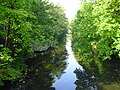
The Isebek Canal is on average 20 meters wide and one to two meters deep, densely overgrown with trees and bushes along the banks and accompanied by several strips of green space. It begins in the Eimsbüttel district ( ⊙ ), forms the border between Hoheluft-Ost and -West as well as Eppendorf north and Harvestehude south and finally flows into the course of the Alster ( ⊙ ) about 500 meters before it widens to the Outer Alster . The canal is expanded to the south of the Hoheluftbrücke ( ⊙ ) to form a basin 250 meters long with a maximum width of 60 meters and then tapers again at its start on Weidenstieg.
One problem is - as with many canals - that the current is weak and the water is heavily polluted with nutrients . Therefore it happens that the water contains too little oxygen . For this reason, ventilation pipes have been laid on the canal floor since 1988, through which the water can be enriched with oxygen if necessary. When this system failed in 2001, most of the fish living in the canal died.
history
The Isebek was a small river, formerly at Bahrenfeld from the Diebsteich (Mühlenteich der Diebsteicher Mühle; old district Defsdiek, Devedick), which flowed into the Alster.
The streets Isebekstraße (not to be confused with Isestraße !) And Isebekstieg remind of this . The thief's pond, for its part, had two tributaries, the larger of which originated about a kilometer to the west on today's Bornkampsweg and was called Bornbek or Isebek. The smaller tributary came from the north and was called Hexengraben. The Isebek served as part of a Landwehr in the 14th century .
After the canal was redesigned in 1883, a tributary was added to carry rainwater and sewage from Hamburg. After 1912, the Isebek Canal was largely filled in and now begins on Weidenstieg near the Christ Church in Eimsbüttel . There is only a small inflow from the pond in Eimsbüttler Park to the north through the course of the small and largely piped Ottersbek between Eichenstrasse and Goebenstrasse, approximately at the level of the Kaiser-Friedrich-Ufer grammar school opposite .
When the Stammsiels overflowed as a result of heavy rain, fish often died in the Isebek Canal. For this reason, a system for oxygen enrichment was installed in 1988. A building with a large rainwater retention basin was also erected on the Lehmweg road on the banks of the canal.
Riparian areas
Kaiser-Friedrich-Ufer
The south-eastern bank of the canal is named Kaiser-Friedrich-Ufer after Kaiser Friedrich III between the beginning in the south and the Hoheluftbrücke . , colloquially shortened to Kaifu . As of 2016, the following facilities are located along the Kaifu and in the area up to the parallel street Hohe Weide , some of which also have Kaifu as part of their name:
- the Kaifu-Bad ( ⊙ ) of the Bäderland Hamburg GmbH, as well as its company headquarters
- the Kaifu Lodge fitness studio ,
- the listed Eimsbütteler bridge
- the occupational therapy- oriented rehab at Kaifu GmbH
- Sports facilities and business premises of Eimsbütteler TV , including a 1,500 m² sports hall, also built with the clinic in February 2014, which is used by schools and the ETV as operator
- the Kaiser-Friedrich-Ufer grammar school
- north of the federal road the regularly developed Kaiser-Friedrich-Ufer road with extensive residential complexes of the non-profit housing cooperative Kaifu Nordland eG,
- On this section of the canal the HoheLuftschiff ( ⊙ ) of the Theater Zeppelin , on which theater for children is performed.
- the Hoheluftbrücke underground station
Isestrasse runs northeast of the Hoheluftbrücke up to the confluence with the Alster , with a continuous residential area between this and the canal bank. On the almost one kilometer long section between Hoheluftbrücke and Eppendorfer Baum, Isestraße is covered on its broad median by a subway viaduct, under which the Isemarkt is held twice a week and is said to be Europe's longest open-air market.
Northwest canal bank
Bismarckstrasse runs at the same height as Kaiser-Friedrich-Ufer on the other side, with residential buildings facing the canal bank along its entire length. From the Hoheluftbrücke, the Lehmweg road runs with a clear view of the canal. Halfway to Eppendorfer Baum, the Lehmweg turns, from there Hegestrasse accompanies the canal at a greater distance through wider residential and commercial properties. From Iseplatz, the continuation of Hegestrasse has the name Isekai for the last 400 meters. At the Isekai shortly before the confluence with the Alster there are boathouses and boat rentals as well as some restaurants and cafes.
Planning
In the 1960s it was planned to fill the Isebek Canal in favor of a motorway route. When this was to be carried out in the mid-1970s, the poet Natias Neutert , the film director Oliver Hirschbiegel and the social pedagogue Erhard Dressel founded the citizens' initiative Rettet den Isebekkanal! whose efforts ultimately led the city to abandon these plans. In the following period, the bank edge was replanted with great effort.
Since the beginning of 2008 the following has been planned for the future design of the south-eastern bank area:
- the redesign of a lounge area on Weidenstieg,
- the new construction or repair of the cycle path,
- the construction of an office building with underground parking and a restaurant on the Hoheluftbrücke .
About the construction of the office building - called Hoheluftkontor - there were then considerable differences between residents, administration and investors. The result of a referendum on this matter in 2010 led to a seven-story residential building with a supermarket on the ground floor being built instead of the office building.
Fish fauna
Carp , tench , bream , alande , roach , rudd , pike , pikeperch , asp , ruff and perch are found in the Isebek Canal . Frequent feeding of waterfowl means that the fish are used to white bread and are relatively easy to catch on the surface of the water in the summer months.
photos

Pedestrian bridge over the Isebek Canal

Bicycle bridge over the Isebek Canal
Isebek Canal upper course

Isebek Canal upper course near Kaifu-Bad
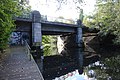
Eimsbütteler Bridge for Bundesstrasse / Osterstrasse

Isebekkanal upper course view from the Bundesstrasse / Osterstrasse


Web links
- Isebek - about monsters and gallows birds (paid article from the Hamburger Abendblatt)
- Image archive / photos from the Isebek Canal
- Eimsbüttel from A – Z Christina Becker ( Memento from September 28, 2007 in the Internet Archive ) (PDF; 237 kB)
Individual evidence
- ↑ Horst Beckershaus, Die Hamburger Straßenennamen, publisher: Die Hanse in der Europäische Verlagsanstalt; 5th edition 2002 ISBN 978-3-434-52603-2
- ↑ The former course of the Isebek between Diebsteich and Weidenstieg / Schäferkamp is shown in Gaedchen's city map from 1880
- ↑ Hamburg city map from 1910 with Isebekstraße / Isebekstieg and the beginning of today's Isebek Canal (in the upper left quarter of the map), accessed on January 11, 2018
- ↑ Michael Bergemann: Complete list of flowing waters in the Elbe catchment area . Authority for the Environment and Energy, Hamburg July 1, 2015 ( fgg-elbe.de [PDF; 802 kB ; accessed on November 29, 2015]).
- ↑ Hamburg city map with the mouth of the Ottersbek
- ↑ Culture City Map Hamburg
- ^ Article in the Hamburger Abendblatt (archive) . Retrieved January 4, 2011.
- ↑ Udo Schroeter: The fishing guide Hamburg - Free waters. The best 150 fishing spots in town, published by Die Rapsbande, Fehmarn, 2005, pp. 17–19, ISBN 978-3-937868-11-0
Coordinates: 53 ° 34 ′ 39 ″ N , 9 ° 58 ′ 25 ″ E