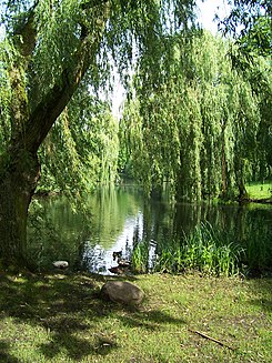
Eimsbütteler Park "Am Weiher"
| Eimsbütteler Park Am Weiher | |
|---|---|
| Park in Hamburg | |

|
|
| Eimsbütteler Park Am Weiher | |
| Basic data | |
| place | Hamburg |
| District | Hamburg-Eimsbüttel |
| Created | from 1832 |
| Surrounding streets | Am Weiher, Im Gehölz, Ottersbekallee, Unnastraße |
| Technical specifications | |
| Parking area | 2.27 ha |
The Eimsbütteler Park "Am Weiher" is a 2.27 hectare park in the Eimsbüttel district of the Hamburg-Eimsbüttel district . The surrounding streets are Unnastraße with the Beiersdorf AG site , the streets Im Gehölz and Am Weiher with the Catholic Church of St. Bonifatius and Ottersbekallee. The surrounding streets are quiet residential streets, which is why the park is known as an inner park with built-up areas. The exception is the street Im Gehölz, which is part of the busy Ring 2 and runs as federal highway 5 directly past the south-eastern end of the park.
history
In the area of today's Eimsbütteler Park there were fish ponds of the St. Johannis monastery in the 17th century . Since the 18th century, the property was owned by the townspeople, who built their properties here. Most recently it belonged to the Lutteroth family. In 1872, Wilhelm Carl Friedrich Büsing from Bremen bought the site to build a park colony. However, the development plans drawn up by civil engineer Westendarp were never implemented. Towards the end of the 19th century, the demand for living space increased and open spaces also became scarce in the Eimsbüttel district. In order to preserve the area for the public as a recreation park, the city bought the green area with the pond and created a footpath around the pond. A new entrance was laid in the street Am Weiher. The name of the Ottersbek is derived from the otters who once lived here and whose dammed part dominates the park.
In 1904 the building deputation had a small toilet block built in the eastern corner of the park, the walls of which - as is usual for such public lavatories - were partly massive and partly as a half-timbered construction. This little house now houses a café and, like the park itself, is a listed building .
After the Second World War, the park was in poor condition as several surrounding buildings had been burned out and trees and bushes had been cut down by the population and used as firewood. The city therefore carried out extensive modernizations that lasted until 1952/1953. A small and a large pond were combined to form today's pond, the connecting bridge was torn down and an island that had been in the large pond was removed. The formerly ornate shoreline was given a clear, streamlined contour. The Ottersbek, which had previously flowed in the south and presented a hygiene problem, was relocated underground. A new entrance to the park was opened on Ottersbekallee. The playground there had to give way, but was replaced by a larger one. After purchasing three pieces of land in Unnastraße, a second playground with a paddling pool was built in 1956/57 in the northwest corner.
description
Park Am Weiher, as it is often called by residents and visitors, is a district park surrounded by residential buildings. The main area is the pond belonging to the Ottersbek. A circular path usually leads directly along the water and meanders through the park. On the bank there are mainly hanging willows , but also chestnuts and maples . The quiet recreation park is characterized by old trees. Many benches are located directly on the bank or on the promenade. A wooden platform on the water offers a view over the pond and is often used to watch the waterfowl. Plantings along the paths separate the park from the surrounding streets. The play areas are away from the paths. The toddler area with a pool, which is usually filled with water in summer, is located on a meadow between Ottersbekallee and Unnastraße. The larger playground is located in the western part of the park by the New Apostolic Church and opposite the St. Bonifatius Church parallel to the street Am Weiher. The park has several entrances and is mostly barrier-free. The historical toilet house at the entrance of the street Im Gehölz has been run as a cafe for several years. The circular route is popular with joggers, a dog meadow is not signposted. The Eimsbütteler Park Am Weiher is a recreation park well protected from traffic noise on Ring 2 with a café for residents and visitors and a well-equipped playground for children and a paddling pool with a playground for the little ones. The medlar ( Mespilus germanica ) , the “ bald cypress ” and the pedunculate oak are listed as special trees .
literature
- Hamburg Grün, The gardens and parks of the city, L & H Verlag Hamburg, 1998, page 118, ISBN 3-928119-39-7
Web links
- List of monuments of the culture and media authority of the Hamburg-Eimsbüttel district
- Special trees
Individual evidence
- ↑ http://www.geoportal-hamburg.de/geo-online/
- ↑ Eimsbütteler Park. Retrieved July 29, 2020 .
- ^ A b Helga Schmal: Monument topography Federal Republic of Germany / 3rd District Eimsbüttel / 1st Eimsbüttel and Hoheluft-West Hans Christians Verlag, Hamburg 1996, ISBN 3-7672-1251-X , p. 44.
- ↑ a b Sielke Salomon, edited by the Morgenland Gallery: Building and Living in Hamburg-Eimsbüttel 1950-1968. Dölling and Galitz Verlag , Hamburg 2000, pp. 166–167
Coordinates: 53 ° 34 ′ 40 ″ N , 9 ° 57 ′ 36 ″ E
