
Ottersbek
| Ottersbek | ||
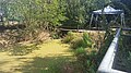
 The Ottersbek on the Bötelkamp |
||
| Data | ||
| River system | Elbe | |
| Drain over | Isebek Canal → Alster → Elbe → North Sea | |
| origin | Start of the open course 53 ° 35 ′ 4 ″ N , 9 ° 57 ′ 10 ″ E |
|
| Source height | about 11 m above sea level NN | |
| muzzle | in the Isebek Canal coordinates: 53 ° 34 '28 " N , 9 ° 57' 58" E 53 ° 34 '28 " N , 9 ° 57' 58" E |
|
| Mouth height | 3.1 m above sea level NN | |
| Height difference | about 7.9 m
|
|
| Big cities | Hamburg | |
| largely piped | ||
The Ottersbek is a brook in the Hamburg districts of Lokstedt and Eimsbüttel , which today is largely piped.
It has a side ditch and is today the only recognizable tributary of the Isebek , which was expanded into a canal. This flows into the Alster .
The brook is the namesake of Ottersbekallee at Eimsbüttler Park.
course
It begins with pipes on Von-Eicken-Straße and runs southwards, under Azaleenweg and Herlingsburg street. The open course begins at the end of the Deepenstöcken dead end. It flows through a retention basin, where it takes up its only side ditch. It continues openly under the street Sorthmannweg and Bötelkamp. Shortly before the Eidelstedter Weg street, it flows underground again, under Telemannstrasse, Heussweg, Lastropsweg and Ottersbekallee. It then flows through the pond in Eimsbütteler Park "Am Weiher" , then it runs piped under the streets Im Gehölz, Alardusstraße and Eppendorfer Weg, then again briefly open, briefly crude and after Tresckowstraße open again. It continues underground under Bismarckstrasse and is open for the last short stretch to the point where it flows into the Isebek Canal .
photos

Dried out Ottersbek on Sorthmannweg (in summer)

Last public open piece of the Ottersbek on Tresckowstrasse
Mouth of the Ottersbek tributary (coming from the bridge) into a RHB of the Ottersbek

Side ditch of the Ottersbek


Web links and sources
- Off to the underground: The Ottersbek
- Hamburg city map with the entry of Ottersbek
- City map of Hamburg / City map of Hamburg on DVD, 2nd expanded and updated edition; State Office for Geoinformation and Surveying Hamburg
- Complete list of rivers in the Elbe catchment area (PDF file; 132 kB)
proof
- ↑ a b Geoportal Hamburg
- ↑ Complete list of rivers in the Elbe catchment area. Retrieved June 30, 2020 .
- ↑ Ottersbek on OpenStreetMap. Retrieved August 16, 2020 .