
Alster locks
|
Tributaries and hydraulic structures
|
|||||||||||||||||||||||||||||||||||||||||||||||||||||||||||||||||||||||||||||||||||||||
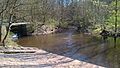
As Alster locks the total of 10 are dams referred mainly the water levels of that help Alster be regulated. They are distributed along the entire length of the river. The two lower Alster locks in Hamburg's inner city also serve to lock ships .
Jam and lock functions
The locks in the Oberalster, above the Mellingburger Schleuse were always simple weirs , also weirs called. Ships could go into the valley after opening the lock gate on the Wasserberg. Today they only have the function of regulating the water level of the Alster. Like the two lower locks in Hamburg's inner city, the Mellingburger, Poppenbüttler and Fuhlsbütteler locks were chamber locks with two gates. Since shipping was stopped above Fuhlsbüttel, the second gates here and in Poppenbüttel have been removed and the remaining gates have been converted into weirs. The Mellingburg lock became a double weir with the old lock basin in between.
The town hall lock and Schaartor lock at the mouth of the Alster and the Elbe serve not only to regulate the water levels of the shipping connection for Alster ships, barges and sports boats between the Elbe and the Outer Alster.
The Alster locks are essential components of worth preserving, Hamburg and its surroundings distinguishing river and lakes from the Alster Lake and the Lake Außenalster and Binnenalster .
![]() Map with all coordinates: OSM | WikiMap
Map with all coordinates: OSM | WikiMap
| Surname | Function (originally / today) / comments | Built / Renewal | location | image |
|---|---|---|---|---|
| Heidkruger lock | Reservoir lock / weir (Schleswig-Holstein / cultural monument, Object-ID: 3819) | 1529 |
Kayhude , Tangstedt 53 ° 45 ′ 12 ″ N, 10 ° 7 ′ 58 ″ E |
<  > >
|
| Sandfield lock | Lock gate / weir | 1528-29 | Tangstedt 53 ° 44 '18 "N, 10 ° 7' 27" E |

|
| Rader lock | Lock gate / weir | 1527-29 | Tangstedt 53 ° 43 '49 "N, 10 ° 7' 28" E |

|
| Wulksfelder lock | Lock gate / weir | 1448 | Tangstedt 53 ° 42 ′ 37 "N, 10 ° 6 ′ 51" E |

|
| Wohldorf lock | Lock gate / weir in the eastern part, in the western part a side weir with the possibility of transferring paddlers, above the weir the Timmermann bridge of the Schleusenredder. New fish ladder planned for completion by 2023. | 1448 |
Duvenstedt , Wohldorf-Ohlstedt 53 ° 42 ′ 17 ″ N, 10 ° 7 ′ 5 ″ E |
<  > >
|
| Mellingburg lock | Lock basin, length: 77 m, width: 49 m, capacity: 20 barges (cultural monument, No. 26867 in the list of cultural monuments of the city of Hamburg . New fish ladder planned for completion by 2023.) | 1528-29 / 1835/1959/1998 |
Poppenbüttel , Sasel 53 ° 40 ′ 13 ″ N, 10 ° 5 ′ 55 ″ E |

|
| Poppenbüttler lock | Formerly lock basin, length: 130 m, today weir. The lower weir of the lock chamber (see picture from 1856), where the baker's bridge is today, no longer exists. A fish ladder will be built by the end of 2020 . | 1528-29 / 1884 | Poppenbüttel 53 ° 39 ′ 27 ″ N, 10 ° 5 ′ 17 ″ E |

|
| Fuhlsbüttel lock | Formerly lock chamber (length 28 m), today weir lock, new building in 2013. The lock marks the transition from the unpaved upper course of the Alster to the canalised lower course. | 1448 / 1862/1914/2013 |
Fuhlsbüttel 53 ° 37 ′ 22 ″ N, 10 ° 1 ′ 42 ″ E |

|
| Town hall lock | Lock chamber: length: 35 m, width: 7.2 m. A second chamber was built in 1890. The lock gates have been operated electrically since 1921, and they are equipped with heaters to protect against frost. In 1973 a new building followed, with additional installation of generators to use the water power of the Alster. | 1846/1973 |
Neustadt , Altstadt 53 ° 33 ′ 5 ″ N, 9 ° 59 ′ 31 ″ E |
<  > >
|
| Schaartor lock | Lock chamber: length: 39 m, width: 7.2 m, depth: 1.4 m, passage height at sea level: 5 m. The lock was built to protect downtown Hamburg after the storm surge in 1962 and replaces the Graskellerschleuse built in 1839. | 1839/1966 | Neustadt, Altstadt 53 ° 32 ′ 44 ″ N, 9 ° 59 ′ 0 ″ E |
.4.ajb.jpg)
|
history
14th to 19th century
Oberalster shipping
.jpg)


In the Middle Ages, the Alster was of fundamental importance for Hamburg's founding, settlement and development. It supplied the drinking water and hydropower for the mills, which were of elementary importance for the population for the production of bread and beer. The area of the Upper Alster was rich in forest (especially oak), peat and boulders , materials that were needed in Hamburg for house and ship building as well as fuel. In the absence of developed country roads, the oak trunks on the Alster were rafted down the river towards Hamburg for centuries. That was not possible with peat and boulders. To secure the rights and use of the Alster, Hamburg acquired three parts of the Alster from Holstein counties between 1306 and 1310, which included the entire Alster course in Holstein. The course of the Alster was mainly used for transporting loads, catching fish and a secure water inlet to operate the mills. The Hamburg council also had police violence on the river and the paths along the Alster. Only the city was authorized to make changes to the Alster.
When Hamburg joined the Hanseatic League of Trade Cities in the 14th century, the city developed into the most important German transshipment point between the North Sea and the Baltic Sea and achieved a previously unknown level of prosperity. There was an intensive movement of goods in the countryside between Hamburg and Lübeck.
In 1448 the people of Hamburg decided to create a navigable connection between Hamburg and Lübeck with the Alster-Beste Canal . The Beste and Trave rivers were already navigable. An eight kilometer long trench, the Alster Canal , had to be dug to connect the Alster to the Norderbeste via the Alte Alster . Nine locks were built in the Alster (to compensate for the 17 m gradient), four locks (8 m gradient ) in the Alster Canal and eight locks (15 m gradient) in the Beste. The Hamburg - Lübeck route was 91 kilometers long. In the course of this construction work, the Wulksfelder, Wohldorfer and Fuhlsbütteler locks were built around 1448. After four years of construction, the project was interrupted for lack of money. The shipping route along the Alster from Stegen to Hamburg was completed in 1465, from Wohldorf a few years earlier.
In 1526 work on the canal was resumed. The Stecknitz Canal, which was completed around 100 years earlier, with its locks, provided the builders with illustrative material for their own construction, as well as the experience of the lock masters of the Stecknitz Canal. In the area of the Nienwohlder Moors, the canal construction turned out to be extremely difficult, as the canal embankments repeatedly collapsed due to the soft and soaked subsoil. Between 1527 and 1529 the sand fields, Rader, Heidkruger, Mellingburger and Poppenbüttler locks were rebuilt and old locks were replaced. A second lock weir was necessary for the Mellingburger and Poppenbüttler locks and the Fuhlsbüttel lock was converted into a box lock. The need for building material, especially for the construction of locks, was enormous and required over 2000 trees. During this time, the towpaths along the Alster and several bridges over the Alster were built. At that time, the entire Alstertal was like a huge construction site on which several thousand people worked.
With the construction of the locks around 1529, the Hamburg council appointed and paid a lock master for each lock. Hamburg built lock masters' houses near some of the locks, of which the houses on the Wohldorfer, Mellingburger, Poppenbüttler and Fuhlsbütteler locks still existed around 1640. The lock master's house at the Fuhlsbütteler lock is mentioned for the first time in 1633 as the “Krughaus”, in which the lock master was in charge of the lock and mill system as well as the right to the bar. In 1704 the lock master’s house was washed away by the Alster flood and was not rebuilt. Some rooms in the Fühlbütteler mill were assigned to the lock master.
With the completion of the locks, the waterway was created with sufficient draft along the Alster for the barges (known as "Alsterbucks"). The ships were pulled by men and women as well as by horses with leashes, grained . Treidelweg or Leinpfad gave their names to the street Leinpfad in Hamburg , along the Alster, the Leinpfad Canal and the Treudelberg ( Treidelberg ) in Poppenbüttel .
The descent - with the current of the Alster - took about two to three days, depending on the water level. The lock keeper was given the task of ensuring a favorable water level through the position of the lock weir. When the lock was opened, the ships drifted down the valley on the tidal wave to the next lock. The ascent on the Alster, on the other hand, was considerably more difficult and took at least a week, or up to four weeks if the water level was poor. This lock operation with only one weir, in contrast to the box lock, was associated with a large waste of water, as the entire amount of pent up water was drained off when the weir was opened. The following lands were often flooded and damaged, which sparked disputes with the landowners.
On August 22, 1529 the first four ships sailed from Lübeck through the canal. It took seven days to tow the ships across the country and to rig them. Shipping was stopped as early as 1550, as there was predominantly water shortage on the apex of the canal between Nienwohld and Sülfeld . The Nienwohlder Moor is located on the watershed between the North Sea and the Baltic Sea, at 29 m above sea level. The abundant peat in the Nienwohlder Moor could still be shipped as fuel from the Heidkruger lock in Kayhude on the Alster to Hamburg.
From 1550 to 1650, Hamburg experienced a strong population increase from 20,000 to 60,000 inhabitants, particularly due to the immigration of Dutch people as a result of the wars of religion , which resulted in a corresponding need for building materials and also had an impact on increased freight transport on the Alster. Between 1603 and 1610, an annual average of 515 ships passed through the Fuhlsbütteler Schleuse; in 1636 there were 688 ships.
In the first half of the 19th century there was the largest number of ships on the Upper Alster with 50 Alster barges. They were divided into four size classes according to their length: full ship (23 m), half ship (19-20 m), quarter ship (16-18 m) and eighth ship (15 m). The board height was around 1 m on all ships. The fully loaded full ship had a draft of 60 cm.
According to the Poppenbüttler lock book, 154 barges passed through the lock in 1860, most of which were loaded with rocks, bricks from brickworks, peat and wood. Furthermore 6 wooden rafts were registered. Between 1880 and 1889 ship transport at the Fuhlsbütteler Schleuse decreased significantly with 52 ships per year, in 1898 there were only 4 ships.
Lock master and lock rules
The operation of the ships on the Oberalster, due to the special nature of the locks, required certain rules, which were laid down in regulations, but were not always adhered to due to conflicting interests. The first known ordinance was drawn up by the Hamburg Council around 1584, in which, among other things, the necessary water depth at the weirs for the wooden ships was regulated. Smooth and speedy ship transport was important for the skippers; in front of the locks they had to gather in boat formations for the passage and follow the instructions of the lock masters, which was not always problem-free. The landowners along the Alster complained about the flooding of their lands associated with the locks. In the end, it was stipulated by ordinance that no people smuggled during the hay harvest in July. The millers on the Alster were dependent on the water supply, which was at least restricted during the locks.
According to the contract, the determination of the shipping regulations along the Alster was the responsibility of the Hamburgers, even if the larger area of the Upper Alster was on Danish territory and later became Prussian. The orderliness of the predominantly Holstein boatmen was accordingly not very pronounced.
The master locks were in the service of the Hamburgers and were responsible for operating and monitoring the locks. The lock master's house was their official residence. They had to take an oath of service for the duties imposed on them. They received salaries from the Hamburg council, T. varied. The lock master of the Poppenbüttler lock received the following annual salaries: 1640 to 1837 11 guilders, 1875 13 marks , 1895 20 marks, 1924 162 Reichsmarks .
The rules of the Oberalster shipping were laid down in a publicly issued regulation from 1825: Regulation, because of the Alster shipping through the Mellingburger, Wohldorfer, Wulksfelder, Rader, Sandfelder and Heidkruger locks (text slightly shortened):
- The overseers of the locks mentioned above are obliged to notify the lock masters of the lower locks about an increased amount of water so that they can open their locks.
- Skippers are forbidden to open or close a lock with a penalty of five Thalers.
- At least five ships have to be together to get through to Poppenbüttler lock.
- Each ship has to pay each lock master five shillings when going down.
- The lock master must notify the forest governor immediately of any violation by the boatmen.
The right to use the Alster by the Hamburg residents was also associated with high technical and financial expense. The locks were made of wood and were subject to high wear and tear, which made repairs necessary. After about 30 years, a lock had to be completely replaced. The costs amounted to 30 to 40 thousand Reichsmarks, which could not be covered by the income from the smuggling and for the most part remained with the Hamburg state. The high maintenance costs and usefulness of the locks have therefore been discussed again and again over the centuries.
Competence dispute over lock rights
The lock master's enforcement of the lock regulations was not always free of conflict. On July 4, 1836 at 10 p.m. there were 7 ships in front of the Poppenbüttler lock that could not be discharged due to low water. At this point in time, a number of Poppenbüttel villagers, led by Pastor Führer , approached the lock master and asked him to open the chutes of the lock immediately. The master locker opposed this on the grounds that the water level in front of the lock was 7 feet and only 14 feet would be necessary for the lock, which would take about 3 hours. Unimpressed by this, the villagers pulled the chutes on their own, whereupon the water drained away. The villagers and their leader, the pastor, who owned considerable land in Poppenbüttel, feared for their haymaking if the further accumulated water would flood their meadows. The predecessor of the lock master had so far done without damming and locks during harvest time.
The master smuggler made a report of the incident to his superior, the landlord of the Geestlande . The incident sparked a legal dispute between the Hamburg council, as the owner of the lock, and the Pinneberger landlord ( Landdrost ) in Holstein under the Danish crown.
Construction of locks and weirs


The Alster locks above the Mellingburg lock were simple weirs at which the water was dammed. When the lock was opened, the ships slid to the next lock on the tidal wave. During the lock process, the water flowed steadily from the upper reaches over the lowered weir. This type of lock, which is associated with a lot of water loss, was only possible with low gradients in the watercourse. For the next lock passage, the water level in front of the weir had to be refilled. To compensate for this disadvantage, a lock procedure was only ever carried out in a group of at least 5 ships (see regulation on Alster shipping).
Second weirs were built to limit water loss, such as the Mellingburger and Poppenbüttler locks, which were referred to as basin locks . Another type of lock is the box lock , like that of the Fuhlsbüttel lock, where the space between the two weirs is further limited. During the lock only the amount of water escapes from the lock basin and can be refilled more quickly for another lock after closing.
The lock weirs, consisting of the sheet pile, side and bottom walls and lock gates, were made entirely of wood, mainly oak, until the 19th century. In some cases, the side walls were made of brick or granite. The weirs had two storage gates (wing gates), which dammed the water and could be opened against the back pressure of the water by means of a chain and a gate winch. The storage gates consisted of a beam construction that formed three compartments in which the chutes (60 cm wide panels) could be vertically raised and lowered. There was a 60 cm free space between the two gates, which was also blocked with movable chutes. To open the chutes, horizontally lying winches (massive trees) were attached above the lock gate, with which the chutes could be pulled out vertically on chains. The winches were turned by inserted hand spokes. The lock master was able to adjust the water level of the Alster in front of the weir using the height of the chute in the dam gate.
A historical drawing of a sluice gate from the building authorities shows seven management levels arranged in parallel, three in each of the two gates with two chutes on top of each other and a guide between the gates with three chutes on top of each other.
To open the storage gates to allow the Alster barges to pass, the chutes were first pulled out completely in order to reduce the ram pressure at the gate. When the upper and lower water levels at the weir were more or less equal, the gates were opened and the ships could slide downhill on the tidal wave. The storage gates have now been replaced by flaps that can be opened to adjust the water level at the lock (see Fig. Poppenbüttler lock).
The lock weirs were between 5.15 and 6.3 meters wide (passage width) and between 11.45 and 12.3 meters long. The height from the lock floor to the upper lock beam was between 3.6 and 4.3 meters.
Circumferential ditches were available at every lock through which the Alster water could be led if the lock had to be drained for repair or renewal. These circuits are still available at the Mellingburger and Poppenbüttler locks.
In December 2015, such a repair case occurred at the Poppenbüttler lock. The weir flap of the lock was damaged by a rescue operation by the police and fire brigade to search for people in the area of the Poppenbüttler lock. The elevator chain of the flap tore off, whereupon the flap sagged and thus lost its dam function for the upstream mill pond, the pond ran empty. For the repair, the area of the weir system was separated from the water inlet by a wooden construction. During the repair work, the water from the Alster was channeled around the lock via the existing circulation canal. A custom-made product was required to replace the elevator chain. The work was completed in June 2016.
Poppenbüttler lock weir (closed) and on the right the circulating canal.
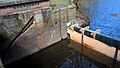
Weir system with a torn elevator chain, the wooden structure at the existing wall openings closes off the chamber area.

Repair work on the weir system, chain pinion not yet attached to the chain.

Weir system with the new chain.


Alster-Elbe shipping connection
A shipping connection between the Alster and Elbe did not exist until the town hall lock was built in 1846. In the outflows from the Alster to the Elbe via the canals in downtown Hamburg , however, there were already weirs and sluices to protect against the Elbe floods and to keep the water level in the canal when the Elbe rivers drained .
The Graskellerschleuse also enabled passage from the Kleiner Alster, the Admiralty Street Fleet to the Elbe. In the course of planning a shipping connection between the Alster and the Elbe , the Graskellerschleuse was already massively rebuilt in 1839 and had a passage for ships up to 18 feet (5.5 meters) wide.
To rebuild Hamburg after the great fire of 1842, the town hall lock was built in 1846 under the lock bridge on the town hall market , which separates the Kleine Alster from the Alsterfleet . This created the first shipping connection from the Alster to the Elbe for the then common barges , ewer and barges . Due to the steadily increasing shipping traffic, a second chamber was built in 1890. The lock gates were still operated by hand cranking.
20th and 21st centuries
Oberalster shipping

.jpg)
The Oberalster shipping came to an end at the beginning of the 20th century. In 1919 there was only one ship left by the authority, which was used for inspection trips until the 1940s. The locks of the Upper Alster still exist today, but their original wooden structures in steel and concrete have been replaced. The Mellingburg lock is an exception. It has been preserved in the original wooden construction and, with the current lock master's house of the Mellingburg lock, which was built in 1717 as an inn for tow boaters, is one of the cultural monuments of Hamburg (list of monuments No. 445 and 446). According to Melhop (page 196), the northern part of the house was built during the construction of the Alster-Trave Canal around 1529 and was later expanded to its current size. The lock master's house of the Wohldorfer Schleuse was restored in 1923 after a fire and is now run as an inn. It is one of the cultural monuments of Hamburg (list of monuments No. 608). The lock master's house of the Poppenbüttler lock from 1824 was built at a higher point than the previous building from 1643 for flood protection reasons. Today it is used as a restaurant and is under monument protection ( monument list of Hamburg , No. 1063).
Today, the locks are only used to regulate the water levels in the Alster. They dump the water level to prevent the Alster from falling dry; a water depth of 50 centimeters is maintained in the area of the Poppenbüttler baker's bridge. In the event of flooding, they should avoid flooding. On February 6th and 7th, 2011, after days of heavy rainfall, the level at the measuring level at the Bäckerbrücke rose by more than two and a half meters, to its highest level to date. The Fuhlsbüttel lock will then be fully opened to relieve the flood. The tidal wave can pour into the large water reserve of the Alster canals, the Outer and Inner Alster without the water level being significantly increased there. From 1999 to 2008, an average water level (MW) of 2.94 m and the highest water level (HW) of 3.18 m were measured at the measuring point of the Krugkoppelbrücke of the Outer Alster.
For preventive flood protection , retention areas for rainwater are designated in the Upper Alster region and floodplain areas are kept free of buildings. For this purpose, an official warning service called “Inland Flood Hamburg” was created in Hamburg. Monitoring is carried out by the lock master of the Schaartor lock, who uses monitors to check the water levels of the Elbe and the Alster up to the Fuhlsbüttel lock.
Fuhlsbüttel lock
The Fuhlsbüttel lock was built in 1914 with a lock chamber and two weir fields on each side of the lock chamber. In 1934 and 1968 the lock was rebuilt. After almost 100 years of operation, the lock was no longer stable, the structure of the lock chamber and the bank walls were porous and cracked. The fish passage at the lock was also badly damaged and no longer allowed fish to climb into the upper reaches of the Alster. In 2011, the lock was completely redesigned in a two-year construction period and now consists of an automatically controllable weir system, which serves to protect against inland flooding on the Alster and to maintain the water level of the Alster. The fish ladder was renewed with a meander fish pass.
The hydropower plant installed in the lock in 2000 remained unchanged. With a drop height of 4 m at the barrage, the system has a nominal output of 110 kW, corresponding to an annual work of around 550,000 kWh, sufficient for 200 households.
To protect the fish fauna so that the fish do not get into the turbine , the inflow speed of the water in front of the rake was reduced by oversizing the inlet channel. In addition, a “fish escape pipe” at the beginning of the inlet channel prevents the fish from entering the turbine. Up to 0.5 m³ / s of the flow rate over the weir are primarily fed to the fish ascent and descent and up to 3.6 m³ / s (maximum absorption volume) to the hydropower plant.
Town hall lock
.jpg)
The town hall lock on the town hall market forms the main outflow of the Inner and Outer Alster via the Alsterfleet into the Elbe. You have the following tasks:
Over the height of the weir of the town hall lock, a constant water level of around 3 meters above normal is maintained on the Inner and Outer Alster, the canalised river course up to the Fuhlsbütteler lock and the connected canals in order to keep this area navigable. The Alster steamers need a depth of at least 1.40 meters.
With its two chambers, each 35 m long and 7.2 m wide, it can lock Alster steamers, barges and pleasure craft. In order to ensure a low-flow entrance area for the ships to the lock, the outflow of the Alster water is interrupted during the lock operation and only carried out at night. During the daily damming phase, with normal Alster influx, the water level rises by 1 cm per hour, which is then reduced again overnight.
In 1921 the lock gates were equipped with electric drives and the drive elements with heaters to prevent them from freezing. In 1973 the lock was rebuilt. In order to use the water power of the Alster, generators were installed to cover the electricity requirements of the lock. In 2013, the electrical switchgear for semi-automatic lock operation was converted by the lock keeper, which also enables remote control and remote monitoring of the lock.
Schaartor lock

The Schaartorschleuse was built in 1967 as a result of the devastating Great Flood of 1962 . It forms the crossing of the Alster from the Alsterfleet into the inland port of the Elbe . It is used to set a largely constant water level in the Alsterfleet below that of the Outer and Inner Alster. The tide-dependent water levels prevail on the Elbe side. The entry and exit on the Elbe side of the lock is made difficult by the variable tidal currents, the current from the lock and from the pumping station.
The Schaartor sluice is part of the dike protection line on the Elbe and protects the Alster against incoming Elbe water when the Elbe floods. Three pumps in the Alster pumping station can push excess water from the Alster into the Elbe against a higher water level in the Elbe. Water levels measured at the St. Pauli water level in 2012: Mean low water (MNW): NN −1.55 m; Mean high tide (MHW): NN + 2.10 m; Highest water level (1976): NN + 6.45 m.
The conveying capacity of the Alster pumping station is given as 129,600 m³ / h. The highest flow rate of the Alster was measured on February 27, 2002 (at the Bäckerbrücke): 131,400 m³ / h (in front of the pumping station, plus the quantities of the Alster tributaries downstream of the Bäckerbrücke).
As part of the baumall flood protection system , the lock barrier was raised and modernized in 2013.
literature
- Wilhelm Melhop : The Alster. Described historically, locally and in terms of river engineering , Hamburg, Hartung, 1932 (668 pages)
- Volker Looks: The Alster, The River and the City , Wachholtz Verlag, September 4, 2012 [2]
- Reinhard Woltmann : Contributions to making the rivers navigable . Heroldsche Buchhandlung, Hamburg 1826, III. About the Alsterfahrt, S. 195-213 ( google.de ).
Web links
Individual evidence
- ↑ a b c d e F. Ziesche: History of the Upper Alster - cargo shipping from 1448 - 1898, prospectus of the Alster Association, October 4, 2003.
- ↑ Wulksfelde gauge
- ↑ a b c d I. Jung: The river that kept Hamburg afloat , Hamburger Abendblatt, June 1, 13.
- ↑ a b c d Angelika Rosenfeld: Alster ships, silver coins and a "castle" - the story of Poppenbüttels. Dobu Verlag, Hamburg 2006, ISBN 3-934632-17-3 , pp. 18-23.
- ↑ a b board: "Alsterschleusen", notice in the Alstertal Museum .
- ↑ Heidkruger Alsterschleuse (Ehlersberger Schleuse) ( Memento from February 25, 2015 in the Internet Archive ), SH monument list, Tangstedt.
- ↑ New fish ladder Wohldorfer Schleuse planned (until 2023) , Environment and Energy Agency , accessed on February 8, 2020
- ↑ Heike Ziesche, Ferdinand Ziesche: Hamburg-Sasel , Sutton Verlag GmbH, 2011, 127 pages.
- ↑ New fish ladder Mellingburger Schleuse planned (until 2023) , Environment and Energy Agency , accessed on February 8, 2020
- ↑ a b c d e f g h i j k l m n o p q Wilhelm Melhop: The Alster. Described historically, locally and in terms of river engineering, Hamburg, Hartung, 1932, Alster-Trave-Kanal pp. 103–116; Lock gates pp. 139–154; Schleusenmeister pp. 166–174; Ship sizes p. 234; Number of ships p. 244.
- ↑ Construction boards at the Mellingburg lock.
- ^ A b c d F. Ziesche: Hamburg Poppenbüttel. (= The series of archive images). Sutton Verlag, 2008, ISBN 978-3-86680-294-0 , p. 117.
- ↑ Fish ladder in Poppenbüttel completed by the end of 2020 , Environment and Energy Agency , accessed on February 8, 2020
- ↑ Information board at the construction site at the lock pond
- ↑ Reinhard Woltmann: Contributions to making the rivers navigable.
- ^ Ohlsdorfer Schleuse ( Memento from February 3, 2016 in the Internet Archive ), Authority for Urban Development and the Environment.
- ↑ a b c Project information: Rathausschleuse Hamburg ( Memento from April 2, 2015 in the Internet Archive ), H&F Industry, April 2013.
- ↑ a b c Rathausschleuse - Hamburg's Gate to the Elbe , Die Welt August 20, 1999.
- ↑ a b History ( Memento of the original from July 4, 2016 in the Internet Archive ) Info: The archive link was inserted automatically and has not yet been checked. Please check the original and archive link according to the instructions and then remove this notice.
- ↑ a b Information board of the Schaartor lock.
- ↑ a b History of Hamburg , accessed on June 8, 2017.
- ↑ [1] , Volker Looks: The Alster - The river and the city - Hamburg's rights to the Alster - history of an opinion dispute .
- ^ A b Alster-Trave Canal , Society for Schleswig-Holstein History.
- ^ Lemsahl-Mellingstedt - A quiet double village with a lot of history , Hamburger Abendblatt.
- ^ The Alster Canal - Hamburg's history until 1956 , Hamburg book.
- ↑ Nienwohld-Geschichte , Amt Bargteheide-Land.
- ↑ Table: Ordinance on Alsterschifffahrt from 1825 , Westphalen Land- und Wald-Herr, Hamburg, March 22, 1825, notice in the Alstertal Museum.
- ↑ Heinz Waldschläger: A Competence Controversy about the Poppenbütteler Alsterschleuse , annual books of the Alsterverein, 2005 (from the Hamburg State Archives, Landherrschaft der Geestlande).
- ↑ Water loss in the Poppenbüttel lock pond , Hamburg, press releases districts, December 16, 2015.
- ↑ Relieved breathing in Poppenbüttel, defective lock will be replaced this month , Heimat Echo, May 2016.
- ^ The builder of the Lombard Bridge in Hamburg Johann Hermann Maack , GERMAN CONSTRUCTION ZEITUNG YEAR 57, Berlin, March 21, 1923.
- ^ Franz Heinrich Neddermeyer: On the statistics and topography of the Free and Hanseatic City of Hamburg and its area , Hoffmann and Campe, 1847.
- ↑ Rathausschleusenbrücke. In: Hamburg's bridges. November 15, 2013, accessed on June 22, 2019 (German).
- ↑ a b c Hamburg, State Office for Geoinformation and Surveying, Dec. 2012
- ↑ Flood Protection Hamburg - Warning Service for Inland Floods , Authority for Urban Development and Environment, January 15, 2013.
- ↑ a b Planning approval decision for the conversion of the Fuhlsbütteler lock , Free and Hanseatic City of Hamburg - Authority for Urban Development and Environment, May 19, 2010.
- ↑ The conversion to a weir system with an integrated fish passage is finished ( Memento from February 24, 2015 in the Internet Archive ), Department for Urban Development and Environment, June 15, 2011.
- ↑ Reconstruction of the Fuhlsbüttler lock , Hartwig-Zeidler, July 2013.
- ↑ Fuhlsbütteler Schleuse hydropower plant , operator group UWW Windstrom Wedel.
- ^ Final report, subproject 2: Hydropower as a renewable energy , Floecksmühle engineering office, October 2011.
- ↑ Hamburgs bridges - Schaartorbrücke ( Memento from April 2, 2015 in the Internet Archive )
- ^ Wilhelm Melhop: The Alster.
Remarks
- ↑ There is no uniform naming of names for the Fuhlsbütteler Schleuse, in the literature the names Fuhlsbüttler Schleuse and Ohlsdorfer Schleuse are also used.