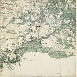
Topographical military map of the Duchy of Holstein

from Wikipedia, the free encyclopedia
Excerpt from the Vahrendorf map of Schleswig-Holstein

The topographical military chart of the Duchy of Holstein , today also called Vahrendorf map , is a topographical map series . It was accepted from 1789 to 1796 by officers of the Schleswig Infantry Regiment under the direction of Gustav Adolf von Varendorf . One geographic mile corresponded to a Hamburg or Holstein foot on the map, which corresponds to a scale of 1: 26.293. It comprises 68 single sheets. Originals are in the Kort og Matrikelstyrelsen , Copenhagen.

Reproduction of the maps

In 1991 the Land Surveying Office of Schleswig-Holstein made a reproduction of the sheets on a scale of 1: 25,000.

leaf Sheet title map
1 Sankt Peter-Ording - Vollerwiek
2 Friedrichstadt - Lunden - Tönning
3 Süderstapel - Meggerdorf
4th Eider mouth
5 Büsum - Wesselburen
6th pagan
7th Erfde - Dellstedt - Tellingstedt
8th Fockbek - Hohn - Westerrönfeld
9 Rendsburg
10 Achterwehr - Gettorf - Kronshagen - Kiel -West Image map of a section
11 Kiel - Friedrichsort - Laboe
12 Schoenberg
13 Scharhörn -West - Large bird sand
14th Neuwerk - Scharhörn -East
15th Outside Elbe - bush sand
16 Dieksand - Meldorfer Bucht
17th Meldorf
18th Albersdorf - Hanerau-Hademarschen
19th Breiholz - Jevenstedt - Todenbüttel
20th Nortorf
21st Bordesholm - Flintbek - Kiel Image map of a section
22nd Kiel -East - Preetz
23 Lütjenburg - Selent
24 Oldenburg in Holstein
25th Heiligenhafen
26th You
27 Cuxhaven
28 Marne - Brunsbuettel
29 Brunsbüttel (harbor) - Burg (Dithmarschen)
30th Schenefeld - Wilster - Itzehoe -Nord
31 Hohenlockstedt - Hohenwestedt - Aukrug -West
32 Neumunster
33 Bornhöved - Gadeland - Wattenbek
34 Plön
35 Eutin - Malente
36 Grömitz - Lensahn - Schönwalde
37 Dahme - Kellenhusen
38 Belum - Neuhaus (Oste) - Otterndorf
39 Brokdorf - Wilstermarsch - Freiburg (Elbe)
40 Glückstadt - Krempe - Itzehoe -Süd
41 Kellinghusen - Brande-Hörnerkirchen
42 Bad Bramstedt - Boostedt
43 Bad Segeberg - Rickling
44 Gnissau - Seedorf - Wensin
45 Ahrensbök - Scharbeutz - Süsel
46 Neustadt in Holstein
47 Cabbage sand
48 Elmshorn - Uetersen - Pagensand
49 Barmstedt - Quickborn
50 Henstedt-Ulzburg - Kaltenkirchen
51 Leezen - Sülfeld
52 Bad Oldesloe - Reinfeld
53 Lübeck - Bad Schwartau
54 Travemünde
55 frond
56 Hamburg - Blankenese - Pinneberg
57 Fuhlsbüttel - Alstertal
58 Bargteheide - Ahrensburg
59 Rethwisch - Sandesneben
60 Lübeck - South - Ratzeburg
61 Buxtehude
62 Altona - Hamburg - Harburg Varendorf (62) Altona Hamburg Harburg.jpg
63 Bergedorf - Reinbek - Wandsbek Varendorf (63) Bergedorf Reinbek.jpg
64 Glinde - Schwarzenbek Varendorf (64) Glinde Schwarzenbek.jpg
65 Breitenfelde - nuts
66 Mölln
67 Pattensen
68 Vierlande - Winsen Varendorf (68) Vierlande Winsen.jpg

See also

Individual evidence

  1. Wolfgang Torge: History of geodesy in Germany. Walter de Gruyter, Berlin and New York 2007, ISBN 3-11-019056-7 , ISBN 978-3-11-019056-4 , page 92.
  2. ^ Varendorf map. Retrieved on November 3, 2018 (German).
  3. State Office for Surveying and Geoinformation Schleswig-Holstein