
Brokdorf
| coat of arms | Germany map | |
|---|---|---|

|
Coordinates: 53 ° 52 ' N , 9 ° 20' E |
|
| Basic data | ||
| State : | Schleswig-Holstein | |
| Circle : | Stone castle | |
| Office : | Wilstermarsch | |
| Height : | 1 m above sea level NHN | |
| Area : | 19.79 km 2 | |
| Residents: | 965 (Dec. 31, 2019) | |
| Population density : | 49 inhabitants per km 2 | |
| Postcodes : | 25576, 25554 | |
| Primaries : | 04829, 04858 | |
| License plate : | IZ | |
| Community key : | 01 0 61 018 | |
| LOCODE : | DE OOF | |
| Office administration address: | Kohlmarkt 25 25554 Wilster |
|
| Website : | ||
| Mayoress : | Elke Göttsche ( CDU ) | |
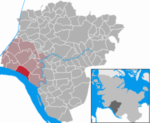
| Location of the municipality Brokdorf in the Steinburg district | ||
  |
||

Brokdorf ( Low German : Brokd Körper / Brookdborough ) is a municipality in the Steinburg district in Schleswig-Holstein .
geography
Brokdorf is located in the Wilstermarsch on the northern bank of the Elbe about 20 km southwest of Itzehoe and 20 km east of Brunsbüttel .
history
The name of the place goes back to one of the oldest Holstein families " von Brockdorff ", to whom the village owes its first documented mention in 1220. The St. Nicholas Church was first mentioned in 1342.
In November 1976, February 1977, February 1981 and June 1986 large-scale demonstrations by opponents of nuclear power against the Brokdorf nuclear power plant , which was under construction, took place in Brokdorf , which made the place known nationwide. The power plant went online in 1986. As of May 2014 , it is to be operated as a power plant until the end of 2021 , a local interim storage facility for radioactive waste has been in operation since 2007 and is approved until 2047.
politics
Community representation
Of the eleven seats in the municipal council has CDU since the local elections in 2013 six seats, the voter community WFTU three and the SPD two seats.
coat of arms
Blazon : "In blue a slanted, silver flying fish over two silver wave threads in the base of the shield."
The symbol chosen for the coat of arms can be traced back to both historical and geographical conditions. The "flying fish" is quoted almost literally from the Brockdorff coat of arms. This old noble family probably had their ancestral home in this church village and named themselves after them. The waves in the base of the shield show the proximity of the village in the Wilstermarsch on the dike to the Elbe . The good marshland made a profitable agriculture possible , the proximity to the water a modest shipping traffic. The blue color of the shield represents the water.
tourism
Brokdorf is located on the German Ferry Road and the Green Coast Road . The place has an Elbe beach and a leisure pool that is open during the summer months. The leisure pool is heated and opens from May to mostly September of the year. The ice rink is open in the winter months . Leisure activities such as cycling, inline skating or jogging can be practiced behind the dike. The Elbe Cycle Route and the North Sea Cycle Route also run along here. There are parking spaces for mobile homes near the fire station . The St. Nicholas Church is regularly open for tours.
Economy and Infrastructure
The Brokdorf nuclear power plant , which was built from 1976 to 1986, is located in the municipality . In addition, many smaller companies have settled here.
photos
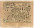
"Brocdorp" 1645 in the Atlas Maior von Blaeu

St. Nicholas

Memorial stone at the church

Aerial photo from 2012

St. Nikolaus from the dike (right)


See also
literature
- Waldtraut Feldtmann: The old Brokdorf. Wachholtz Verlag, Neumünster 1992, ISBN 3-529-02727-8 .
- Waldtraut Feldtmann: The new Brokdorf. Wachholtz Verlag, Neumünster 1997, ISBN 978-3-529-02804-5 .
Web links
- Brokdorf municipality
- Johann Friedrich Dörfer: Topography of Holstein in alphabetical order: A repertory to the map of the Duchy of Holstein, the areas of the imperial cities of Hamburg and Lübek, and the Diocese of Lübek , Verlag Röffs, 1807, "Brokdorf" p. (89, 90) at digital collections ( MDZ )
- Texts and historical views on "Brokdorf" at mein-wilster-de
- Brokdorf on foot, New Year's Eve 2015 Video on YouTube
Individual evidence
- ↑ North Statistics Office - Population of the municipalities in Schleswig-Holstein 4th quarter 2019 (XLSX file) (update based on the 2011 census) ( help on this ).
- ↑ see also the list of cultural monuments in Brokdorf
- ↑ http://orf.at/stories/2229625/2229629/ Vortex about "bad bank" for nuclear power plants - total risk to the state? ORF.at from May 12, 2014
- ↑ Schleswig-Holstein's municipal coat of arms
- ↑ Motorhome parking spaces | Brokdorf on the Elbe. Retrieved January 24, 2018 .
Carrion | Abbissinwish | Agethorst | Altenmoor | Auufer | Bahrenfleth | Beidenfleth | Bekdorf | Bekmünde | Besdorf | Blomean Wilderness | Bokelrehm | Bokhorst | Borsfleth | Breitenberg | Breitenburg | Brokdorf | Brokstedt | Büttel | Christinenthal | Dägeling | Dammfleth | Drage | Ecklak | Elskop | Engelbrecht Wilderness | Fitzbek | Glückstadt | Grevenkop | Gribbohm | Hadenfeld | Heiligenstedten | Heiligenstedtenerkamp | Hennstedt | Heart horn | Hingstheide | Hodorf | Hohenaspe | Hohenfelde | Hohenlockstedt | Holstenniendorf | Horst (Holstein) | Huje | Itzehoe | Kaaks | Kaisborstel | Kellinghusen | Lapwing row | Kleve | Kollmar | Kollmoor | Krempdorf | Brim | Kremperheide | Krempermoor | Kronsmoor | Krummendiek | Kudensee | Lägerdorf | Land law | Landscheide | Lockstedt | Lohbarbek | Looft | Mehlbek | Moordiek | Moorhusen | Mühlenbarbek | Münsterdorf | Neuenbrook | Neuendorf b. Elmshorn | Neuendorf-Sachsenbande | Nienbüttel | Nortorf | Nutteln | Oelixdorf | Oeschebüttel | Oldenborstel | Oldendorf | Ottenbüttel | Peissen | Pöschendorf | Poyenberg | Pulse | Quarnstedt | Wheel | Reher | Rethwisch | Rosdorf | Sankt Margarethen | Sarlhusen | Schenefeld | Schlotfeld | Silzen | Summer land | Stördorf | Störkathen | Süderau | Vaale | Vaalermoor | Wacken | Warring wood | Westermoor | Wewelsfleth | Wiedenborstel | Wills | Wilster | Winseldorf | Wittenbergen | Wrist | Wulfsmoor