
Huje
| coat of arms | Germany map | |
|---|---|---|

|
Coordinates: 53 ° 59 ' N , 9 ° 26' E |
|
| Basic data | ||
| State : | Schleswig-Holstein | |
| Circle : | Stone castle | |
| Office : | Itzehoe country | |
| Height : | 9 m above sea level NHN | |
| Area : | 5.54 km 2 | |
| Residents: | 278 (Dec. 31, 2019) | |
| Population density : | 50 inhabitants per km 2 | |
| Postal code : | 25588 | |
| Area code : | 04827 | |
| License plate : | IZ | |
| Community key : | 01 0 61 045 | |
| Office administration address: | Margarete-Steiff-Weg 3 25524 Itzehoe |
|
| Website : | ||
| Mayoress : | Renate Lüschow | |
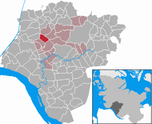
| Location of the community Huje in the Steinburg district | ||
  |
||

Huje is a municipality in the Steinburg district in Schleswig-Holstein .
Geography and traffic
Huje is about 6 km northwest (10 km by road) from Itzehoe . The Bekau , the Moorbek , the Mühlenbach and the Krammbek flow through the municipality.
history
Huje is mentioned for the first time in 1217 and once served as a stacking or herding place, i.e. as an unloading place for ships.
politics
coat of arms

The “coat of arms” of the community cannot be heraldically described and is therefore not a coat of arms in the actual sense, but rather to be assigned to the image seals. It was elected by the community after the Second World War in the absence of official seals that are free from National Socialist and Imperial symbols and is still used today.
Wind farm
The Huje wind farm is located between Huje and Nutteln, with 15 Vestas V66 / 1650 wind turbines with a total output of 24750 kW. The wind farm will be repowered in 2017 . A total of 13 new systems with a height of 200 meters are to be built. A large majority of residents in order to protect the natural oasis " Tongrube Muldsberg " have spoken out against repowering .
photos

Boulder in place
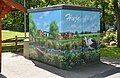
Painted transformer box
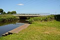
Canoe berth on the Bekau


Web links
Individual evidence
- ↑ North Statistics Office - Population of the municipalities in Schleswig-Holstein 4th quarter 2019 (XLSX file) (update based on the 2011 census) ( help on this ).
- ↑ Schleswig-Holstein's municipal coat of arms
- ^ Wikipedia: Coats of arms in Schleswig-Holstein approved by the British military government
- ↑ Database for wind turbines and wind parks
- ↑ Wind Wahn Huje
Carrion | Abbissinwish | Agethorst | Altenmoor | Auufer | Bahrenfleth | Beidenfleth | Bekdorf | Bekmünde | Besdorf | Blomean Wilderness | Bokelrehm | Bokhorst | Borsfleth | Breitenberg | Breitenburg | Brokdorf | Brokstedt | Büttel | Christinenthal | Dägeling | Dammfleth | Drage | Ecklak | Elskop | Engelbrecht Wilderness | Fitzbek | Glückstadt | Grevenkop | Gribbohm | Hadenfeld | Heiligenstedten | Heiligenstedtenerkamp | Hennstedt | Heart horn | Hingstheide | Hodorf | Hohenaspe | Hohenfelde | Hohenlockstedt | Holstenniendorf | Horst (Holstein) | Huje | Itzehoe | Kaaks | Kaisborstel | Kellinghusen | Lapwing row | Kleve | Kollmar | Kollmoor | Krempdorf | Brim | Kremperheide | Krempermoor | Kronsmoor | Krummendiek | Kudensee | Lägerdorf | Land law | Landscheide | Lockstedt | Lohbarbek | Looft | Mehlbek | Moordiek | Moorhusen | Mühlenbarbek | Münsterdorf | Neuenbrook | Neuendorf b. Elmshorn | Neuendorf-Sachsenbande | Nienbüttel | Nortorf | Nutteln | Oelixdorf | Oeschebüttel | Oldenborstel | Oldendorf | Ottenbüttel | Peissen | Pöschendorf | Poyenberg | Pulse | Quarnstedt | Wheel | Reher | Rethwisch | Rosdorf | Sankt Margarethen | Sarlhusen | Schenefeld | Schlotfeld | Silzen | Summer land | Stördorf | Störkathen | Süderau | Vaale | Vaalermoor | Wacken | Warring wood | Westermoor | Wewelsfleth | Wiedenborstel | Wills | Wilster | Winseldorf | Wittenbergen | Wrist | Wulfsmoor