Beidenfleth
| coat of arms | Germany map | |
|---|---|---|

|
Coordinates: 53 ° 53 ' N , 9 ° 25' E |
|
| Basic data | ||
| State : | Schleswig-Holstein | |
| Circle : | Stone castle | |
| Office : | Wilstermarsch | |
| Height : | 5 m above sea level NHN | |
| Area : | 13.57 km 2 | |
| Residents: | 838 (Dec. 31, 2019) | |
| Population density : | 62 inhabitants per km 2 | |
| Postal code : | 25573 | |
| Primaries : | 04823, 04829 | |
| License plate : | IZ | |
| Community key : | 01 0 61 007 | |
| LOCODE : | DE AT | |
| Office administration address: | Kohlmarkt 25 25554 Wilster |
|
| Website : | ||
| Mayor : | Andreas Lorenz ( CDU ) | |
| Location of the municipality of Beidenfleth in the Steinburg district | ||

Beidenfleth ( Low German : Beidenfleet ) is a municipality in the Steinburg district in Schleswig-Holstein . Beidenfleth has no other districts.
Geography and traffic
Beidenfleth is located in the Wilstermarsch on the right (western) bank of the Stör . The Beidenflether Hafen is mainly used by pleasure boats. The Altenfeld weather , which flows into the Stör over the harbor basin, and the Groß-Kampen weather run through the municipality .
history
Beidenfleth was first mentioned in the Annales regni Francorum (sub anno 809) when emissaries of Charlemagne and the Danish King Göttrik met there in 809 . However, the name Badenfliot only appears in some of the manuscripts.
From the 12th century onwards, Dutch settlers dug the drainage ditches that are still visible today . The first chapel, named after St. Nicholas , was built in 1108, but was soon replaced by a stone church. The free-standing tower, reminiscent of a mill, was built in 1557. In the church there is a medieval bronze baptismal font , several medieval carvings and a baroque altar.
Beidenfleth has existed as a political municipality since 1876.
politics
coat of arms
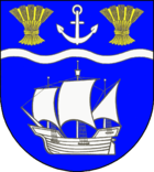
Blazon : "In blue a raised silver wavy bar, above a silver anchor between two golden grain sheaves, below a silver three-masted holk with full sails."
The community is located on the sturgeon in the Holstein Elbmarsch. Shipping on the Stör and the nearby Elbe has always had an important economic significance for the community. The cargo ship (Holk), which dates back to the 15th century, is intended to remind of the historical as well as current importance of this branch of the economy. The sheaves of ears indicate the importance of agriculture . The anchor is reminiscent of St. Nicholas , the coat of arms of the Beidenfleth parish.
Culture and sights
Architectural landmarks of the place are or were the Church of St. Nicolai and - until April 17, 2016 - the windmill Hope . The mill burned down completely that night. The Beidenfleth Camera Museum is located in the old school , a technology museum that has been in existence since 2011.
The Else sturgeon ferry is operated as one of the last of its kind . It represents a tourist attraction and is the only way to Störquerung between the twelve kilometers upriver bascule bridge in Heiligenstedten and ten kilometers downstream on the Störsperrwerk in Wewelsfleth leading bundesstraße 431 .
Personalities
- Heinrich Hudemann (1595–1628), poet of the Baroque period
- Heinrich Plütschau (1676–1752), first Lutheran missionary (together with Bartholomäus Ziegenbalg ), was pastor here from 1714 to 1752
See also
- List of cultural monuments in Beidenfleth (with Groß-Kampen)
literature
- HA Becker: Die Stör Der Stör , Verlag BoD, 1970/2002, pp. 6, 7 + 40, “Badenfliot” / Beidenfleth reading samples from Google Books
Web links
- Beidenfleth community at the Wilstermarsch office
- Johann Friedrich Dörfer: Topography of Holstein in alphabetical order: A repertory to the map of the Duchy of Holstein, the areas of the imperial cities of Hamburg and Lübek, and the Diocese of Lübek. Verlag Röffs, 1807, “Beyenfleth” page (74). In: digital collections ( MDZ )
- Texts and historical postcards from Beidenfleth. In: mein-wilster-de
Individual evidence
- ↑ North Statistics Office - Population of the municipalities in Schleswig-Holstein 4th quarter 2019 (XLSX file) (update based on the 2011 census) ( help on this ).
- ↑ Aasbüttel - Bordesholm . In: Wolfgang Henze (ed.): Schleswig-Holstein topography: cities and villages of the country . 1st edition. tape 1 . Flying-Kiwi-Verl. Junge, Flensburg 2001, ISBN 3-926055-58-8 , p. 259 .
- ↑ Beidenfleth Church
- ↑ Schleswig-Holstein's municipal coat of arms


