
Nutteln (Holstein)
| coat of arms | Germany map | |
|---|---|---|

|
Coordinates: 53 ° 59 ' N , 9 ° 23' E |
|
| Basic data | ||
| State : | Schleswig-Holstein | |
| Circle : | Stone castle | |
| Office : | Schenefeld | |
| Height : | 15 m above sea level NHN | |
| Area : | 6.97 km 2 | |
| Residents: | 252 (Dec. 31, 2019) | |
| Population density : | 36 inhabitants per km 2 | |
| Postal code : | 25594 | |
| Area code : | 04827 | |
| License plate : | IZ | |
| Community key : | 01 0 61 078 | |
| Office administration address: | Mühlenstrasse 2 25560 Schenefeld |
|
| Website : | ||
| Mayor : | Eckhard Breßler (KWG) | |
| Location of the municipality of Nutteln in the Steinburg district | ||
  |
||

Nutteln is a municipality in the Steinburg district in Schleswig-Holstein .
Geography and traffic
Nutteln is located about 10 km northwest of Itzehoe and directly south of Vaale on the L 327 state road (formerly Bundesstraße 431 ), almost exactly on the border between the Marsch and the Geest . The Nutteln stream flows through the community .
history
The village name "Nutle" was first mentioned in 1247. This name is probably derived from the older name "Nutloh". The meaning of the place name can therefore be given as a grove or "grove with nut bushes".
politics
Community representation
Since the municipal elections in 2013, the KWG electoral community has had all nine municipal council seats.
coat of arms
Blazon : "On a green hill in blue three silver trees with no leaves, the crowns of which disappear into the upper edge of the shield."
In addition to a hint of the historical landscape, the coat of arms of the municipality of Nutteln primarily depicts the place name.
photos

Main Street of Nutteln
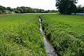
Nuttelner Bach in place


Web links
Individual evidence
- ↑ North Statistics Office - Population of the municipalities in Schleswig-Holstein 4th quarter 2019 (XLSX file) (update based on the 2011 census) ( help on this ).
- ↑ Schleswig-Holstein's municipal coat of arms
Carrion | Abbissinwish | Agethorst | Altenmoor | Auufer | Bahrenfleth | Beidenfleth | Bekdorf | Bekmünde | Besdorf | Blomean Wilderness | Bokelrehm | Bokhorst | Borsfleth | Breitenberg | Breitenburg | Brokdorf | Brokstedt | Büttel | Christinenthal | Dägeling | Dammfleth | Drage | Ecklak | Elskop | Engelbrecht Wilderness | Fitzbek | Glückstadt | Grevenkop | Gribbohm | Hadenfeld | Heiligenstedten | Heiligenstedtenerkamp | Hennstedt | Heart horn | Hingstheide | Hodorf | Hohenaspe | Hohenfelde | Hohenlockstedt | Holstenniendorf | Horst (Holstein) | Huje | Itzehoe | Kaaks | Kaisborstel | Kellinghusen | Lapwing row | Kleve | Kollmar | Kollmoor | Krempdorf | Brim | Kremperheide | Krempermoor | Kronsmoor | Krummendiek | Kudensee | Lägerdorf | Land law | Landscheide | Lockstedt | Lohbarbek | Looft | Mehlbek | Moordiek | Moorhusen | Mühlenbarbek | Münsterdorf | Neuenbrook | Neuendorf b. Elmshorn | Neuendorf-Sachsenbande | Nienbüttel | Nortorf | Nutteln | Oelixdorf | Oeschebüttel | Oldenborstel | Oldendorf | Ottenbüttel | Peissen | Pöschendorf | Poyenberg | Pulse | Quarnstedt | Wheel | Reher | Rethwisch | Rosdorf | Sankt Margarethen | Sarlhusen | Schenefeld | Schlotfeld | Silzen | Summer land | Stördorf | Störkathen | Süderau | Vaale | Vaalermoor | Wacken | Warring wood | Westermoor | Wewelsfleth | Wiedenborstel | Wills | Wilster | Winseldorf | Wittenbergen | Wrist | Wulfsmoor