
Neuendorf b. Elmshorn
| coat of arms | Germany map | |
|---|---|---|

|
Coordinates: 53 ° 44 ' N , 9 ° 33' E |
|
| Basic data | ||
| State : | Schleswig-Holstein | |
| Circle : | Stone castle | |
| Office : | Horst-Herzhorn | |
| Height : | 6 m above sea level NHN | |
| Area : | 15.78 km 2 | |
| Residents: | 841 (Dec. 31, 2019) | |
| Population density : | 53 inhabitants per km 2 | |
| Postal code : | 25335 | |
| Primaries : | 04121, 04128 | |
| License plate : | IZ | |
| Community key : | 01 0 61 074 | |
| Office administration address: | Elmshorner Strasse 27 25358 Horst |
|
| Website : | ||
| Mayor : | Hans-Peter Saß-Thormählen (KWV) | |
| Location of the community Neuendorf b. Elmshorn in the Steinburg district | ||
  |
||

Neuendorf b. Elmshorn ( Low German : Neendbod bi Elmshoorn ) is a municipality in the southern Steinburg district in Schleswig-Holstein . Bauernweg, Datendorf, Dorreihe, Fleien, Kirchdorf, Kronsnest, Kuhle, Lühnhüserdeich and Moorhusen are located in the municipality.
geography
Neuendorf is predominantly agricultural and, due to its location in the middle of wide fields and meadows in the Seestermüher Marsch along the Krückau, it is an attraction for day-trippers.
politics
Since the local elections in 2018, the KWV voter community has all eleven seats in the municipal council.
Attractions
In the center of the village is the Trinity Church with origins from the 16th and 17th centuries. The high church roof with the ridge turret is visible from afar in the march.
The historic Kronsnest ferry , probably the smallest ferry in Germany , runs between Neuendorf and Seester . It is the only hand-operated ferry in Schleswig-Holstein and transports people and bicycles across the Krückau . It has been in operation again since May 1993 and the crossing takes place with the ferry boat built from oak wood according to the historical model. Depending on the water level of the tributary of the Lower Elbe, which is exposed to the tides , a distance of 16 to 40 meters has to be covered.
Sons and daughters of the church
- Johannes Peters (1841–1909), member of the Reichstag and Landtag, president of the Berlin Higher Administrative Court, member of the Prussian manor house
- Ernst Engelbrecht-Greve (1916–1990), German politician ( CDU ), Member of the Bundestag , Member of the State of Schleswig-Holstein, Minister of Agriculture and Deputy Prime Minister in Schleswig-Holstein
- Nis R. Nissen (1925–2000), historian and museum director, honorary professor of the state of Schleswig-Holstein

Trinity Church

Typical farmhouse of the Seestermüher Marsch in Neuendeich
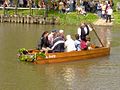
Kronsnest ferry


Web links
Individual evidence
- ↑ North Statistics Office - Population of the municipalities in Schleswig-Holstein 4th quarter 2019 (XLSX file) (update based on the 2011 census) ( help on this ).
- ↑ Schleswig-Holstein topography. Vol. 7: Munkbrarup - Pohnsdorf . 1st edition Flying-Kiwi-Verl. Junge, Flensburg 2006, ISBN 978-3-926055-88-0 , p. 53 ( dnb.de [accessed on July 21, 2020]).
- ^ Election result Neuendorf b. Elmshorn
Carrion | Abbissinwish | Agethorst | Altenmoor | Auufer | Bahrenfleth | Beidenfleth | Bekdorf | Bekmünde | Besdorf | Blomean Wilderness | Bokelrehm | Bokhorst | Borsfleth | Breitenberg | Breitenburg | Brokdorf | Brokstedt | Büttel | Christinenthal | Dägeling | Dammfleth | Drage | Ecklak | Elskop | Engelbrecht Wilderness | Fitzbek | Glückstadt | Grevenkop | Gribbohm | Hadenfeld | Heiligenstedten | Heiligenstedtenerkamp | Hennstedt | Heart horn | Hingstheide | Hodorf | Hohenaspe | Hohenfelde | Hohenlockstedt | Holstenniendorf | Horst (Holstein) | Huje | Itzehoe | Kaaks | Kaisborstel | Kellinghusen | Lapwing row | Kleve | Kollmar | Kollmoor | Krempdorf | Brim | Kremperheide | Krempermoor | Kronsmoor | Krummendiek | Kudensee | Lägerdorf | Land law | Landscheide | Lockstedt | Lohbarbek | Looft | Mehlbek | Moordiek | Moorhusen | Mühlenbarbek | Münsterdorf | Neuenbrook | Neuendorf b. Elmshorn | Neuendorf-Sachsenbande | Nienbüttel | Nortorf | Nutteln | Oelixdorf | Oeschebüttel | Oldenborstel | Oldendorf | Ottenbüttel | Peissen | Pöschendorf | Poyenberg | Pulse | Quarnstedt | Wheel | Reher | Rethwisch | Rosdorf | Sankt Margarethen | Sarlhusen | Schenefeld | Schlotfeld | Silzen | Summer land | Stördorf | Störkathen | Süderau | Vaale | Vaalermoor | Wacken | Warring wood | Westermoor | Wewelsfleth | Wiedenborstel | Wills | Wilster | Winseldorf | Wittenbergen | Wrist | Wulfsmoor