
Grevenkop
| coat of arms | Germany map | |
|---|---|---|

|
Coordinates: 53 ° 51 ' N , 9 ° 32' E |
|
| Basic data | ||
| State : | Schleswig-Holstein | |
| Circle : | Stone castle | |
| Office : | Krempermarsch | |
| Height : | 0 m above sea level NHN | |
| Area : | 9.63 km 2 | |
| Residents: | 327 (Dec. 31, 2019) | |
| Population density : | 34 inhabitants per km 2 | |
| Postal code : | 25361 | |
| Area code : | 04824 | |
| License plate : | IZ | |
| Community key : | 01 0 61 030 | |
| Office administration address: | Birkenweg 29 25361 Krempe |
|
| Website : | ||
| Mayor : | Hans-Otto Schröder (KWG) | |
| Location of the Grevenkop community in the Steinburg district | ||
  |
||

Grevenkop ( Low German : Grevenkoop ) is a municipality in the Steinburg district in Schleswig-Holstein .
Geography and traffic
Grevenkop is ten kilometers south of Itzehoe in the Elbmarsch. The federal highway 23 runs to the east from Elmshorn to Itzehoe. The Kremper Au flows through the municipality.
The districts of Achtern Riep, Audeich, Schmerland, Riep and Muschelnorf belong to the community.
politics
coat of arms
Blazon : "In gold, a red-armored black swan walking to the right with raised wings."
Grevenkop is one of the so-called seven Kremper Marsch villages. These communities have a uniform coat of arms. For more information see: Office Krempermarsch
swell
- ↑ North Statistics Office - Population of the municipalities in Schleswig-Holstein 4th quarter 2019 (XLSX file) (update based on the 2011 census) ( help on this ).
- ↑ Schleswig-Holstein topography. Vol. 3: Ellerbek - Groß Rönnau . 1st edition Flying-Kiwi-Verl. Junge, Flensburg 2003, ISBN 978-3-926055-73-6 , p. 298 ( dnb.de [accessed April 26, 2020]).
- ↑ Schleswig-Holstein's municipal coat of arms
Web links

Boulder at Landesstraße 119
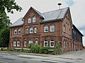
Marschhof on the main street
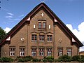
Marschhof on the main street


Carrion | Abbissinwish | Agethorst | Altenmoor | Auufer | Bahrenfleth | Beidenfleth | Bekdorf | Bekmünde | Besdorf | Blomean Wilderness | Bokelrehm | Bokhorst | Borsfleth | Breitenberg | Breitenburg | Brokdorf | Brokstedt | Büttel | Christinenthal | Dägeling | Dammfleth | Drage | Ecklak | Elskop | Engelbrecht Wilderness | Fitzbek | Glückstadt | Grevenkop | Gribbohm | Hadenfeld | Heiligenstedten | Heiligenstedtenerkamp | Hennstedt | Heart horn | Hingstheide | Hodorf | Hohenaspe | Hohenfelde | Hohenlockstedt | Holstenniendorf | Horst (Holstein) | Huje | Itzehoe | Kaaks | Kaisborstel | Kellinghusen | Lapwing row | Kleve | Kollmar | Kollmoor | Krempdorf | Brim | Kremperheide | Krempermoor | Kronsmoor | Krummendiek | Kudensee | Lägerdorf | Land law | Landscheide | Lockstedt | Lohbarbek | Looft | Mehlbek | Moordiek | Moorhusen | Mühlenbarbek | Münsterdorf | Neuenbrook | Neuendorf b. Elmshorn | Neuendorf-Sachsenbande | Nienbüttel | Nortorf | Nutteln | Oelixdorf | Oeschebüttel | Oldenborstel | Oldendorf | Ottenbüttel | Peissen | Pöschendorf | Poyenberg | Pulse | Quarnstedt | Wheel | Reher | Rethwisch | Rosdorf | Sankt Margarethen | Sarlhusen | Schenefeld | Schlotfeld | Silzen | Summer land | Stördorf | Störkathen | Süderau | Vaale | Vaalermoor | Wacken | Warring wood | Westermoor | Wewelsfleth | Wiedenborstel | Wills | Wilster | Winseldorf | Wittenbergen | Wrist | Wulfsmoor