
Borsfleth
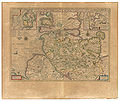
| coat of arms | Germany map | |
|---|---|---|

|
Coordinates: 53 ° 50 ' N , 9 ° 26' E |
|
| Basic data | ||
| State : | Schleswig-Holstein | |
| Circle : | Stone castle | |
| Office : | Horst-Herzhorn | |
| Height : | 2 m above sea level NHN | |
| Area : | 15.19 km 2 | |
| Residents: | 715 (Dec. 31, 2019) | |
| Population density : | 47 inhabitants per km 2 | |
| Postal code : | 25376 | |
| Primaries : | 04124, 04824 | |
| License plate : | IZ | |
| Community key : | 01 0 61 015 | |
| LOCODE : | DE BFL | |
| Office administration address: | Elmshorner Strasse 27 25358 Horst |
|
| Website : | ||
| Mayor : | Peter Mohr (KWV) | |
| Location of the municipality of Borsfleth in the Steinburg district | ||
  |
||

Borsfleth ( Low German : Borsfleet ) is a municipality in the Steinburg district in Schleswig-Holstein . In addition to the church village, it consists of the four villages of Büttel, Eltersdorf, Ivenfleth and Wisch.
Geography and traffic
Borsfleth is about five kilometers north of Glückstadt an der Stör and the Elbe . The Kremper Au and the Große Wetter flow through the municipality.
history
Borsfleth was first mentioned in a document in 1307 and, in addition to the church village, consists of the four Duchten (villages) Büttel, Wisch (1349), Eltersdorf (1360) and Ivenfleth (1230). The actual founding will probably go back well into the 13th century, especially since Borsfleth's history is connected with the mention of a monastery, because the forerunner of the Cistercian nunnery in Itzehoe was on a still existing worm in front of today's sturgeon dike near Ivenfleth until it was moved to its current location around 1263. The place name Borsfleth means something like "Fleet where perch are".
In 1263 the village was moved to its current location. In 1627/28 it was almost completely destroyed in the Thirty Years' War and suffered serious damage again just a few years later, in the period from 1657 to 1660 in the Second Swedish War.
The entrance to the village is characterized by the old Verlathschleuse with the bridge over the Krempau . It was renewed in 1994. From here you have a direct view of the church with the neo-Gothic tower from 1900. One of the last clinker streets in the Steinburg district is located in the church village . The old pastorate with its approximately one hectare large, tree-lined garden forms the center of the church village.
With the completion of the village renewal carried out from 1984 to 1987, the community published a chronicle.
The Borsflether Dutch windmill from 1822 was demolished and has been on display in the Hessenpark open-air museum for several years .
Assignments
On January 1, 1974, a sub-area with then around 30 residents was assigned to the city of Glückstadt .
politics
Community representation
Of the nine seats in the municipal council has Wählergemeinschaft KWV since the local elections in 2018 six seats and the voter community BfB has three seats.
coat of arms
Blazon : "In red a striding golden swan with raised wings and silver reinforcement."
Borsfleth is one of the so-called seven Kremper-Marsch-Villages. These communities have a uniform coat of arms. For more information see: Office Krempermarsch . The old flag of the Kremper Marsch shows a white swan in red with a crown around its neck. The coat of arms has been in this form for the Stormarn landscape for 500 years. In order to do justice to the old tradition, the villages of the former "Kremper-Marsch-Kommüne" have adopted the old swan coat of arms in a slightly different form and without a crown, whereby the colors change from village to village to distinguish them.
Attractions
In addition to the “Old Village School” from 1683, the pastorate , St. Urban Church and Kokemüller's former house are listed in Borsfleth . Other thatched roof houses are considered cultural monuments .
The community is characterized by restored half-timbered houses .
Personalities
The writer Helmut Heißenbüttel (1921–1996) lived in Borsfleth for many years.
The Low German writer Elke Wriedt (* 1941) lives in Borsfleth.
See also
photos
"Borsflete" 1645 in the Atlas Maior von Blaeu

School from 1683
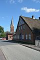
View into the village street, in the background the St. Urban Church

The Verlathschleuse on the Krempau with a rest area

Boat landing stage after the Verlathschleuse on the Krempau, the Stör has low tide
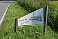
Sign at the end of the village


literature
- HA Becker: The sturgeon The sturgeon . Verlag BoD, 1970/2002, pp. 40-43.
Web links
- Borsfleth community at the Horst-Herzhorn office
- Link catalog about Borsfleth at curlie.org (formerly DMOZ )
- Johann Friedrich Dörfer: Topography of Holstein in alphabetical order: A repertory to the map of the Duchy of Holstein, the areas of the imperial cities of Hamburg and Lübek, and the Diocese of Lübek , Verlag Röffs, 1807, "Borsfleth" p. (82) at digital collections ( MDZ )
- Texts and historical views on "Borsfleth" at mein-wilster-de
- Chronicle of St. Urban at the parish of Borsfleth
Individual evidence
- ↑ North Statistics Office - Population of the municipalities in Schleswig-Holstein 4th quarter 2019 (XLSX file) (update based on the 2011 census) ( help on this ).
- ↑ a b Schleswig-Holstein topography. Vol. 2: Boren - Ellerau . 1st edition Flying-Kiwi-Verl. Junge, Flensburg 2002, ISBN 978-3-926055-68-2 , p. 32 ( dnb.de [accessed June 12, 2020]).
- ^ Federal Statistical Office (ed.): Historical municipality directory for the Federal Republic of Germany. Name, border and key number changes in municipalities, counties and administrative districts from May 27, 1970 to December 31, 1982 . W. Kohlhammer GmbH, Stuttgart / Mainz 1983, ISBN 3-17-003263-1 , p. 186 .
- ^ Result Borsfleth
- ↑ Schleswig-Holstein's municipal coat of arms
Carrion | Abbissinwish | Agethorst | Altenmoor | Auufer | Bahrenfleth | Beidenfleth | Bekdorf | Bekmünde | Besdorf | Blomean Wilderness | Bokelrehm | Bokhorst | Borsfleth | Breitenberg | Breitenburg | Brokdorf | Brokstedt | Büttel | Christinenthal | Dägeling | Dammfleth | Drage | Ecklak | Elskop | Engelbrecht Wilderness | Fitzbek | Glückstadt | Grevenkop | Gribbohm | Hadenfeld | Heiligenstedten | Heiligenstedtenerkamp | Hennstedt | Heart horn | Hingstheide | Hodorf | Hohenaspe | Hohenfelde | Hohenlockstedt | Holstenniendorf | Horst (Holstein) | Huje | Itzehoe | Kaaks | Kaisborstel | Kellinghusen | Lapwing row | Kleve | Kollmar | Kollmoor | Krempdorf | Brim | Kremperheide | Krempermoor | Kronsmoor | Krummendiek | Kudensee | Lägerdorf | Land law | Landscheide | Lockstedt | Lohbarbek | Looft | Mehlbek | Moordiek | Moorhusen | Mühlenbarbek | Münsterdorf | Neuenbrook | Neuendorf b. Elmshorn | Neuendorf-Sachsenbande | Nienbüttel | Nortorf | Nutteln | Oelixdorf | Oeschebüttel | Oldenborstel | Oldendorf | Ottenbüttel | Peissen | Pöschendorf | Poyenberg | Pulse | Quarnstedt | Wheel | Reher | Rethwisch | Rosdorf | Sankt Margarethen | Sarlhusen | Schenefeld | Schlotfeld | Silzen | Summer land | Stördorf | Störkathen | Süderau | Vaale | Vaalermoor | Wacken | Warring wood | Westermoor | Wewelsfleth | Wiedenborstel | Wills | Wilster | Winseldorf | Wittenbergen | Wrist | Wulfsmoor