
Störkathen
| coat of arms | Germany map | |
|---|---|---|

|
Coordinates: 53 ° 59 ′ N , 9 ° 45 ′ E |
|
| Basic data | ||
| State : | Schleswig-Holstein | |
| Circle : | Stone castle | |
| Office : | Kellinghusen | |
| Height : | 5 m above sea level NHN | |
| Area : | 2.03 km 2 | |
| Residents: | 103 (Dec. 31, 2019) | |
| Population density : | 51 inhabitants per km 2 | |
| Postal code : | 25548 | |
| Area code : | 04822 | |
| License plate : | IZ | |
| Community key : | 01 0 61 103 | |
| Office administration address: | Am Markt 9 25548 Kellinghusen |
|
| Website : | ||
| Mayor : | Yves Carpenter (WGS) | |
| Location of the community of Störkathen in the Steinburg district | ||
  |
||

Störkathen ( Low German : Stöörkaten ) is a municipality in the Steinburg district in Schleswig-Holstein .
Geography and traffic
Störkathen is four kilometers northeast of Kellinghusen in the Aukrug Nature Park . The sturgeon flows through the community. To the south, the federal highway 206 runs from Itzehoe to Bad Bramstedt , to the east the railway line from Elmshorn to Neumünster .
Attractions
The Störkathener Heide nature reserve is located on the left bank of the Stör . An educational trail leads through the area .
politics
Community representation
Since the local elections in 2008, the WGS community of voters has all seven municipal council seats.
coat of arms
Blazon : "Above a blue corrugated shield base, inside a silver sturgeon, in silver a red cottage."
photos

The "Dbodshus"
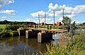
The old weir in the Stör is the municipality's only cultural monument

old sturgeon river course


Web links
Individual evidence
- ↑ North Statistics Office - Population of the municipalities in Schleswig-Holstein 4th quarter 2019 (XLSX file) (update based on the 2011 census) ( help on this ).
- ↑ Schleswig-Holstein's municipal coat of arms
Carrion | Abbissinwish | Agethorst | Altenmoor | Auufer | Bahrenfleth | Beidenfleth | Bekdorf | Bekmünde | Besdorf | Blomean Wilderness | Bokelrehm | Bokhorst | Borsfleth | Breitenberg | Breitenburg | Brokdorf | Brokstedt | Büttel | Christinenthal | Dägeling | Dammfleth | Drage | Ecklak | Elskop | Engelbrecht Wilderness | Fitzbek | Glückstadt | Grevenkop | Gribbohm | Hadenfeld | Heiligenstedten | Heiligenstedtenerkamp | Hennstedt | Heart horn | Hingstheide | Hodorf | Hohenaspe | Hohenfelde | Hohenlockstedt | Holstenniendorf | Horst (Holstein) | Huje | Itzehoe | Kaaks | Kaisborstel | Kellinghusen | Lapwing row | Kleve | Kollmar | Kollmoor | Krempdorf | Brim | Kremperheide | Krempermoor | Kronsmoor | Krummendiek | Kudensee | Lägerdorf | Land law | Landscheide | Lockstedt | Lohbarbek | Looft | Mehlbek | Moordiek | Moorhusen | Mühlenbarbek | Münsterdorf | Neuenbrook | Neuendorf b. Elmshorn | Neuendorf-Sachsenbande | Nienbüttel | Nortorf | Nutteln | Oelixdorf | Oeschebüttel | Oldenborstel | Oldendorf | Ottenbüttel | Peissen | Pöschendorf | Poyenberg | Pulse | Quarnstedt | Wheel | Reher | Rethwisch | Rosdorf | Sankt Margarethen | Sarlhusen | Schenefeld | Schlotfeld | Silzen | Summer land | Stördorf | Störkathen | Süderau | Vaale | Vaalermoor | Wacken | Warring wood | Westermoor | Wewelsfleth | Wiedenborstel | Wills | Wilster | Winseldorf | Wittenbergen | Wrist | Wulfsmoor