
Bekdorf
| coat of arms | Germany map | |
|---|---|---|

|
Coordinates: 53 ° 56 ' N , 9 ° 25' E |
|
| Basic data | ||
| State : | Schleswig-Holstein | |
| Circle : | Stone castle | |
| Office : | Itzehoe country | |
| Height : | 4 m above sea level NHN | |
| Area : | 1.7 km 2 | |
| Residents: | 105 (Dec 31, 2019) | |
| Population density : | 62 inhabitants per km 2 | |
| Postal code : | 25554 | |
| Area code : | 04823 | |
| License plate : | IZ | |
| Community key : | 01 0 61 008 | |
| LOCODE : | DE B8I | |
| Office administration address: | Margarete-Steiff-Weg 3 25524 Itzehoe |
|
| Website : | ||
| Mayor : | Matthias Kelting | |
| Location of the municipality of Bekdorf in the Steinburg district | ||
  |
||

Bekdorf ( Low German : Beekd Körper ) is a municipality in the Steinburg district in Schleswig-Holstein . Bekdorf is a very small municipality in terms of area and is in 92nd place in the list of the smallest municipalities in Germany . So the community only consists of the place Bekdorf.
Geography and traffic
The Bekau flows through Bekdorf . The place is on the federal highway 5 and the march railway between Wilster and Itzehoe . The Wilster and Itzehoe train stations are the closest railway stations. Bus routes operated by the Steinburg transport association connect Bekdorf with Itzehoe on weekdays.
history
Bekdorf is first mentioned in a document in 1247.
At the bridge over the Bekau there was a fight between the Danes and Swedes during the Swedish-Polish War in 1657 .
politics
coat of arms
The “coat of arms” of the community cannot be heraldically described and is therefore not a coat of arms in the actual sense, but rather to be assigned to the image seals. It was elected by the community after the Second World War in the absence of official seals that are free from National Socialist and Imperial symbols and is still used today.
The description in the main statute of the municipality reads: "The coat of arms of the municipality of Bekdorf shows three farmhouses, black and red, on a silver background, a silver nettle leaf in the blue water, above a green dike edge."
photos

Seal of the municipality of Bekdorf
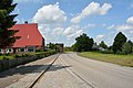
Main road
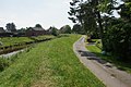
The Bekau in Bekdorf

The Bekau


Web links
See also
Individual evidence
- ↑ North Statistics Office - Population of the municipalities in Schleswig-Holstein 4th quarter 2019 (XLSX file) (update based on the 2011 census) ( help on this ).
- ↑ Aasbüttel - Bordesholm . In: Wolfgang Henze (ed.): Schleswig-Holstein topography: cities and villages of the country . 1st edition. tape 1 . Flying-Kiwi-Verl. Junge, Flensburg 2001, ISBN 3-926055-58-8 , p. 263 .
- ↑ Schleswig-Holstein's coat of arms. Retrieved October 14, 2018 .
- ↑ Main statute of the municipality of Bekdorf ( Memento from March 16, 2007 in the Internet Archive ) (PDF; 332 kB)
Carrion | Abbissinwish | Agethorst | Altenmoor | Auufer | Bahrenfleth | Beidenfleth | Bekdorf | Bekmünde | Besdorf | Blomean Wilderness | Bokelrehm | Bokhorst | Borsfleth | Breitenberg | Breitenburg | Brokdorf | Brokstedt | Büttel | Christinenthal | Dägeling | Dammfleth | Drage | Ecklak | Elskop | Engelbrecht Wilderness | Fitzbek | Glückstadt | Grevenkop | Gribbohm | Hadenfeld | Heiligenstedten | Heiligenstedtenerkamp | Hennstedt | Heart horn | Hingstheide | Hodorf | Hohenaspe | Hohenfelde | Hohenlockstedt | Holstenniendorf | Horst (Holstein) | Huje | Itzehoe | Kaaks | Kaisborstel | Kellinghusen | Lapwing row | Kleve | Kollmar | Kollmoor | Krempdorf | Brim | Kremperheide | Krempermoor | Kronsmoor | Krummendiek | Kudensee | Lägerdorf | Land law | Landscheide | Lockstedt | Lohbarbek | Looft | Mehlbek | Moordiek | Moorhusen | Mühlenbarbek | Münsterdorf | Neuenbrook | Neuendorf b. Elmshorn | Neuendorf-Sachsenbande | Nienbüttel | Nortorf | Nutteln | Oelixdorf | Oeschebüttel | Oldenborstel | Oldendorf | Ottenbüttel | Peissen | Pöschendorf | Poyenberg | Pulse | Quarnstedt | Wheel | Reher | Rethwisch | Rosdorf | Sankt Margarethen | Sarlhusen | Schenefeld | Schlotfeld | Silzen | Summer land | Stördorf | Störkathen | Süderau | Vaale | Vaalermoor | Wacken | Warring wood | Westermoor | Wewelsfleth | Wiedenborstel | Wills | Wilster | Winseldorf | Wittenbergen | Wrist | Wulfsmoor