
Kudensee (municipality)
| coat of arms | Germany map | |
|---|---|---|

|
Coordinates: 53 ° 56 ' N , 9 ° 13' E |
|
| Basic data | ||
| State : | Schleswig-Holstein | |
| Circle : | Stone castle | |
| Office : | Wilstermarsch | |
| Height : | 9 m above sea level NHN | |
| Area : | 3.04 km 2 | |
| Residents: | 118 (Dec. 31, 2019) | |
| Population density : | 39 inhabitants per km 2 | |
| Postal code : | 25572 | |
| Area code : | 04858 | |
| License plate : | IZ | |
| Community key : | 01 0 61 060 | |
| Office administration address: | Kohlmarkt 25 25554 Wilster |
|
| Website : | ||
| Mayoress : | Anja Finke (AWV) | |
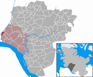
| Location of the municipality of Kudensee in the Steinburg district | ||
  |
||

Kudensee is a municipality in the Steinburg district in Schleswig-Holstein . Sushörn and Fiefhusen are in the municipality.

Geography and traffic
Kudensee is located about five kilometers northeast of Brunsbüttel on the Kiel Canal . The state road 276 and the German ferry road run through the municipality . The canal ferry Stettin connects the municipality with the municipality of Averlak . The federal road 5 leads over the area of the municipality.
history
The community Kudensee was first mentioned in 1454 under the name "Uth dem Kudensee". Its history is closely linked to major water management measures and changes. The first settlers came towards the end of the 16th century and initially took possession of the meadows on the shores of the shallow Kudensee . They built small thatched cottages on the moor bordering the lake . In 1765 the Büttel Canal was built to drain the Kudensee. The construction of the Kiel Canal cut through the municipality (much later). Around 1700 peat was transported on the waterways from Kudensee u. a. carried out in the harbor of the nearby Brunsbüttel . The “Kudenseer Kahn” was used for this purpose, a nine-meter-long barge that could hold up to 7000 sod peat .
politics
Community leader
Kudensee became an independent municipality through the Prussian rural municipality order of 1868. The first elected municipality leaders were Klaus Kloppenburg (until 1875), Jakob Eymers (until 1893), Jakob Kloppenburg (until May 1900) and then Hinrich Prüß (until May 1900) at least 1913).
Community representation
Since the local elections in 2013, the constituency of the AWV has all seven municipal council seats.
coat of arms
Blazon : "In blue a left-turned silver single-masted boat with full sails, including two crossed golden pipes."
The “Kudenseer Kahn” in the municipal coat of arms is intended to remind of the once economic importance of the peat and its transport, the crossed pipes in the base of the shield of the smoking women sung about in the “Kudenseer Lied”. The blue background color refers to the diverse relationships between Lake Kudensee and the water.
sports clubs
The sport fishing club Kudensee has around 100 members.
photos
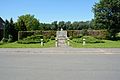
Memorial in Kudensee

The Burg-Kudenseer Canal (Büttel Canal) at the pumping station to the Kiel Canal

Painted transformer box

The ferry dock


Web links
Individual evidence
- ↑ North Statistics Office - Population of the municipalities in Schleswig-Holstein 4th quarter 2019 (XLSX file) (update based on the 2011 census) ( help on this ).
- ↑ Schleswig-Holstein topography. Vol. 6: Kronprinzenkoog - Mühlenrade . 1st edition Flying-Kiwi-Verl. Junge, Flensburg 2006, ISBN 978-3-926055-85-9 , pp. 47 ( dnb.de [accessed June 26, 2020]).
- ↑ Chronicle of the parish of St. Margarethen, also a history of the southwestern Wilstermarsch by W. Jensen, Glückstadt 1913, page 143
- ↑ Schleswig-Holstein's municipal coat of arms
Carrion | Abbissinwish | Agethorst | Altenmoor | Auufer | Bahrenfleth | Beidenfleth | Bekdorf | Bekmünde | Besdorf | Blomean Wilderness | Bokelrehm | Bokhorst | Borsfleth | Breitenberg | Breitenburg | Brokdorf | Brokstedt | Büttel | Christinenthal | Dägeling | Dammfleth | Drage | Ecklak | Elskop | Engelbrecht Wilderness | Fitzbek | Glückstadt | Grevenkop | Gribbohm | Hadenfeld | Heiligenstedten | Heiligenstedtenerkamp | Hennstedt | Heart horn | Hingstheide | Hodorf | Hohenaspe | Hohenfelde | Hohenlockstedt | Holstenniendorf | Horst (Holstein) | Huje | Itzehoe | Kaaks | Kaisborstel | Kellinghusen | Lapwing row | Kleve | Kollmar | Kollmoor | Krempdorf | Brim | Kremperheide | Krempermoor | Kronsmoor | Krummendiek | Kudensee | Lägerdorf | Land law | Landscheide | Lockstedt | Lohbarbek | Looft | Mehlbek | Moordiek | Moorhusen | Mühlenbarbek | Münsterdorf | Neuenbrook | Neuendorf b. Elmshorn | Neuendorf-Sachsenbande | Nienbüttel | Nortorf | Nutteln | Oelixdorf | Oeschebüttel | Oldenborstel | Oldendorf | Ottenbüttel | Peissen | Pöschendorf | Poyenberg | Pulse | Quarnstedt | Wheel | Reher | Rethwisch | Rosdorf | Sankt Margarethen | Sarlhusen | Schenefeld | Schlotfeld | Silzen | Summer land | Stördorf | Störkathen | Süderau | Vaale | Vaalermoor | Wacken | Warring wood | Westermoor | Wewelsfleth | Wiedenborstel | Wills | Wilster | Winseldorf | Wittenbergen | Wrist | Wulfsmoor