
Kollmar
| coat of arms | Germany map | |
|---|---|---|

|
Coordinates: 53 ° 44 ' N , 9 ° 30' E |
|
| Basic data | ||
| State : | Schleswig-Holstein | |
| Circle : | Stone castle | |
| Office : | Horst-Herzhorn | |
| Height : | 0 m above sea level NHN | |
| Area : | 32.82 km 2 | |
| Residents: | 1676 (Dec. 31, 2019) | |
| Population density : | 51 inhabitants per km 2 | |
| Postal code : | 25377 | |
| Primaries : | 04124, 04128 | |
| License plate : | IZ | |
| Community key : | 01 0 61 118 | |
| LOCODE : | DE KOL | |
| Office administration address: | Elmshorner Strasse 27 25358 Horst |
|
| Website : | ||
| Mayor : | Klaus Meinert (WG) | |
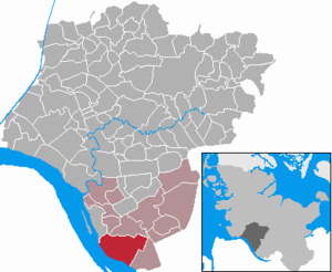
| Location of the community of Kollmar in the Steinburg district | ||
  |
||

Kollmar is a municipality in the Steinburg district in Schleswig-Holstein . Bielenberg, Schleuer, Steindeich, Strohdeich, Moorhusen and Langenhals.
Geography and traffic
Kollmar is located about 13 km west of Elmshorn directly on the Elbe in the Kremper Marsch . The federal highway 431 runs northeast from Elmshorn to Glückstadt .
history
Kollmar was first mentioned in 1377 as a parish to the parish of Asvlet. Asvlet was situated towards the Elbe from Kollmar and went down in the waters of the Elbe. The parish was last mentioned in 1393.
Hans von Ahlefeldt acquired the Haseldorfer Marsch in 1494, which at that time also included Seestermühe and Kollmar. The Ahlefeldts remained in the possession of Kollmar until 1626. They had Oevelgönne Castle (= "evil favor") built in 1586 . The builder was the Italian Franz de Rocha. In 1815 the dilapidated castle was demolished. In 1959, during construction work at the intersection of the streets Strohdeich-Deichzeile-Langenhals (coordinates: approx. 53.751169, 9.473952), remnants of the former Schloss- Wurt were found, including fragments of masonry and sandstone decorations and cobblestones
In 1657/58 the place was almost completely destroyed by Swedish mercenaries.
The Klein-Kollmar and Groß-Kollmar estates were established in 1716 and in 1820, Count von Kielmannsegge - owner of Klein-Kollmar since 1776 - also took over the Groß-Kollmar estate. In 1862 he sold the estate to established farmers.
Today's community was created on September 1, 1974 through the merger of the communities Groß Kollmar and Klein Kollmar.
politics
Of the 13 seats in the municipal council, the WG voter community has had five seats since the 2018 local elections. CDU and SPD each have four seats.
coat of arms
Blazon : “Divided by green and blue by a flattened golden hill. At the top two fanned golden ears of wheat connected to the stalks by a ribbon, at the bottom a fallen silver anchor, entwined with a golden rope. "
economy
Kollmar is a parish village and is still mainly agricultural. Tourism ( local recreation ) also plays a role. The place is also home to many commuters who work in the nearby Elmshorn , Glückstadt or Hamburg .
Personalities
- Thusnelda Kühl (born August 14, 1872 in Kollmar; † July 24, 1935 in Rendsburg), writer
Attractions
Kollmar is often visited by day trippers from the surrounding areas, who watch the ships passing by on the banks of the Elbe. In contrast to the Seestermüher Marsch and parts of the Haseldorfer Marsch, the fairway is close to the shore and is not covered by any Elbe island.
Also worth seeing is the Kollmar church from the middle of the 15th century, a single-nave brick building with a three-sided east end.
In 2003 the Erdwallholländermühle from 1815 burned down completely together with the historic outbuilding.
See also
- List of cultural monuments in Kollmar (with Bielenberg and Steindeich ).
- Timeline for the Lower Elbe region
photos
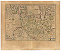
"Colmar" (and "Bileberg") 1645 in the Atlas Maior von Blaeu

The village church of Kollmar

Memorial stone on the former palace square

Brake behind the (Kollmar) Bielenberger Elbe dike

Radar tower at the Kollmarer Steindeich


literature
- Helmut Trede: Kollmar, A marching village on the banks of the Elbe , Husum Printing and Publishing Company, Husum, 2002, ISBN 3-89876-079-0
Web links
Individual evidence
- ↑ North Statistics Office - Population of the municipalities in Schleswig-Holstein 4th quarter 2019 (XLSX file) (update based on the 2011 census) ( help on this ).
- ↑ Schleswig-Holstein topography. Vol. 5: Holt - Krokau . 1st edition Flying-Kiwi-Verl. Junge, Flensburg 2005, ISBN 978-3-926055-79-8 , pp. 308 ( dnb.de [accessed on July 20, 2020]).
- ↑ "The Oevelgönne Castle" near Trede, Kollmar , pp. 70–80.
- ^ Federal Statistical Office (ed.): Historical municipality directory for the Federal Republic of Germany. Name, border and key number changes in municipalities, counties and administrative districts from May 27, 1970 to December 31, 1982 . W. Kohlhammer GmbH, Stuttgart / Mainz 1983, ISBN 3-17-003263-1 , p. 186 .
- ↑ Kollmar election results
- ↑ Schleswig-Holstein's municipal coat of arms
Carrion | Abbissinwish | Agethorst | Altenmoor | Auufer | Bahrenfleth | Beidenfleth | Bekdorf | Bekmünde | Besdorf | Blomean Wilderness | Bokelrehm | Bokhorst | Borsfleth | Breitenberg | Breitenburg | Brokdorf | Brokstedt | Büttel | Christinenthal | Dägeling | Dammfleth | Drage | Ecklak | Elskop | Engelbrecht Wilderness | Fitzbek | Glückstadt | Grevenkop | Gribbohm | Hadenfeld | Heiligenstedten | Heiligenstedtenerkamp | Hennstedt | Heart horn | Hingstheide | Hodorf | Hohenaspe | Hohenfelde | Hohenlockstedt | Holstenniendorf | Horst (Holstein) | Huje | Itzehoe | Kaaks | Kaisborstel | Kellinghusen | Lapwing row | Kleve | Kollmar | Kollmoor | Krempdorf | Brim | Kremperheide | Krempermoor | Kronsmoor | Krummendiek | Kudensee | Lägerdorf | Land law | Landscheide | Lockstedt | Lohbarbek | Looft | Mehlbek | Moordiek | Moorhusen | Mühlenbarbek | Münsterdorf | Neuenbrook | Neuendorf b. Elmshorn | Neuendorf-Sachsenbande | Nienbüttel | Nortorf | Nutteln | Oelixdorf | Oeschebüttel | Oldenborstel | Oldendorf | Ottenbüttel | Peissen | Pöschendorf | Poyenberg | Pulse | Quarnstedt | Wheel | Reher | Rethwisch | Rosdorf | Sankt Margarethen | Sarlhusen | Schenefeld | Schlotfeld | Silzen | Summer land | Stördorf | Störkathen | Süderau | Vaale | Vaalermoor | Wacken | Warring wood | Westermoor | Wewelsfleth | Wiedenborstel | Wills | Wilster | Winseldorf | Wittenbergen | Wrist | Wulfsmoor