
Engelbrechtian wilderness
| coat of arms | Germany map | |
|---|---|---|

|
Coordinates: 53 ° 47 ' N , 9 ° 27' E |
|
| Basic data | ||
| State : | Schleswig-Holstein | |
| Circle : | Stone castle | |
| Office : | Horst-Herzhorn | |
| Height : | 1 m above sea level NHN | |
| Area : | 5.13 km 2 | |
| Residents: | 883 (Dec. 31, 2019) | |
| Population density : | 172 inhabitants per km 2 | |
| Postal code : | 25348 | |
| Area code : | 04124 | |
| License plate : | IZ | |
| Community key : | 01 0 61 027 | |
| Office administration address: | Elmshorner Strasse 27 25358 Horst (Holstein) |
|
| Website : | ||
| Mayor : | Sönke Reimers (KWV) | |
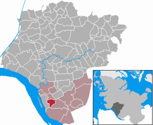
| Location of the Engelbrechtsche Wildnis community in the Steinburg district | ||
  |
||

Engelbrechtsche Wildnis is a municipality in the Steinburg district in Schleswig-Holstein .
Geography and traffic
The Engelbrechtsche Wildnis community is located directly east of Glückstadt . The Herzhorn Rhin and the Schwarzwasser flow through the municipality .
Engelbrechtsche Wildnis is a large municipality without its own town center and consists of individual farmsteads and the settlements Am Herzhorner Rhin, Grillchaussee, Herrendeich, Obendeich and Schwarzer Weg.
history
The settlement of the community began after the dike in the Herzhorn wilderness in 1615. From 1350 to 1640 the area belonged to the Schauenburg counts from Adolf VII to Otto V. Since then it has been owned by the Danish kings. In 1671 Christian V left the area to his illegitimate half-brother Ulrich Friedrich Gyldenlöwe . On December 23, 1697, the community was spun off as a noble estate from the Herzhorn dominion. After Güldenlöwe's death in 1704 Ferdinand Anthon zu Laurwig Gutsherr was until 1754 , then from 1754 to 1783 Christian Conrad von Danneskjold-Laurwigen , from 1783 to 1861 Friedrich Ludwig Ernst von Bülow and finally from 1861 to 1867 the namesake Johannes Engelbrecht (1832-1914). With a contract dated June 15, 1860, he had bought the wilderness for 440,000 Danish Reichsbanktaler ( Rigsbankdaler ) and also assumed the debt of 216,800 Reichsbanktaler.
In 1889 the estate was abolished by the Prussian state. The municipality became an independent municipality that initially administered itself. With the formation of the district of Herzhorn on October 1, 1889, the police administration was transferred to the chief officer. In 1950 the community joined the Herzhorn office .
On January 1, 1974, a sub-area with then about 200 inhabitants was assigned to the city of Glückstadt .
politics
Since the local elections in 2013 , the KWV electoral community has all eleven seats in the local council.
Historic Buildings
The brick buildings of the former Glückstadt naval hospital , which was inaugurated in 1942, are located on Grillchaussee . The Glückstadt Psychiatric Center has been located there since 1978, an institution of the Vitanas Group based in Berlin (as of 2015).
In addition, the community has numerous farmhouses, some of which were supplemented by extensions or separate houses during the early days of the company. One of the big old farmhouses is located at Herzhorner Rhin 21 and now houses an inn. When the house was expanded in 1877, the magnificent entrance gable was created with a woman figure above the entrance depicting the fertility goddess Flora.
See also
photos

(Geluckstadt) ”Wyltenys” 1650, map Johannes Mejer

Engelbrecht Wilderness, settlement on the Herzhorner Rhin
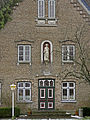
Gable of the house Herzhorner Rhin 21, called Puppenhuus


Web links
- Engelbrechtsche Wildnis community near Horst-Herzhorn
- Johann Friedrich Dörfer: Topography of Holstein in alphabetical order: A repertory to the map of the Duchy of Holstein, the areas of the imperial cities of Hamburg and Lübek, and the Diocese of Lübek , Verlag Röffs, 1807, "Wildnis" S. (293-294) at digital collections ( MDZ )
Individual evidence
- ↑ North Statistics Office - Population of the municipalities in Schleswig-Holstein 4th quarter 2019 (XLSX file) (update based on the 2011 census) ( help on this ).
- ↑ Schleswig-Holstein topography. Vol. 3: Ellerbek - Groß Rönnau . 1st edition Flying-Kiwi-Verl. Junge, Flensburg 2003, ISBN 978-3-926055-73-6 , p. 49 ( dnb.de [accessed April 17, 2020]).
- ^ Federal Statistical Office (ed.): Historical municipality directory for the Federal Republic of Germany. Name, border and key number changes in municipalities, counties and administrative districts from May 27, 1970 to December 31, 1982 . W. Kohlhammer GmbH, Stuttgart / Mainz 1983, ISBN 3-17-003263-1 , p. 186 .
- ^ Election result Engelbrechtsche Wildnis
Carrion | Abbissinwish | Agethorst | Altenmoor | Auufer | Bahrenfleth | Beidenfleth | Bekdorf | Bekmünde | Besdorf | Blomean Wilderness | Bokelrehm | Bokhorst | Borsfleth | Breitenberg | Breitenburg | Brokdorf | Brokstedt | Büttel | Christinenthal | Dägeling | Dammfleth | Drage | Ecklak | Elskop | Engelbrecht Wilderness | Fitzbek | Glückstadt | Grevenkop | Gribbohm | Hadenfeld | Heiligenstedten | Heiligenstedtenerkamp | Hennstedt | Heart horn | Hingstheide | Hodorf | Hohenaspe | Hohenfelde | Hohenlockstedt | Holstenniendorf | Horst (Holstein) | Huje | Itzehoe | Kaaks | Kaisborstel | Kellinghusen | Lapwing row | Kleve | Kollmar | Kollmoor | Krempdorf | Brim | Kremperheide | Krempermoor | Kronsmoor | Krummendiek | Kudensee | Lägerdorf | Land law | Landscheide | Lockstedt | Lohbarbek | Looft | Mehlbek | Moordiek | Moorhusen | Mühlenbarbek | Münsterdorf | Neuenbrook | Neuendorf b. Elmshorn | Neuendorf-Sachsenbande | Nienbüttel | Nortorf | Nutteln | Oelixdorf | Oeschebüttel | Oldenborstel | Oldendorf | Ottenbüttel | Peissen | Pöschendorf | Poyenberg | Pulse | Quarnstedt | Wheel | Reher | Rethwisch | Rosdorf | Sankt Margarethen | Sarlhusen | Schenefeld | Schlotfeld | Silzen | Summer land | Stördorf | Störkathen | Süderau | Vaale | Vaalermoor | Wacken | Warring wood | Westermoor | Wewelsfleth | Wiedenborstel | Wills | Wilster | Winseldorf | Wittenbergen | Wrist | Wulfsmoor