Krempermoor
| coat of arms | Germany map | |
|---|---|---|

|
Coordinates: 53 ° 53 ' N , 9 ° 29' E |
|
| Basic data | ||
| State : | Schleswig-Holstein | |
| Circle : | Stone castle | |
| Office : | Krempermarsch | |
| Height : | 7 m above sea level NHN | |
| Area : | 1.55 km 2 | |
| Residents: | 560 (Dec. 31, 2019) | |
| Population density : | 361 inhabitants per km 2 | |
| Postal code : | 25569 | |
| Area code : | 04824 | |
| License plate : | IZ | |
| Community key : | 01 0 61 057 | |
| Office administration address: | Birkenweg 29 25361 Krempe |
|
| Website : | ||
| Mayor : | Pure Kortas | |
| Location of the municipality of Krempermoor in the Steinburg district | ||
Krempermoor is a municipality in the Steinburg district in Schleswig-Holstein . Hörn and Achtermoor are in the municipality. Krempermoor is a very small municipality in terms of area and is in 67th place in the list of the smallest municipalities in Germany .
Geography and traffic
Krempermoor is located three kilometers south of Itzehoe in an extensive moor area. The Kremperheide train station is located directly on the northern border of the municipality . Krempermoor is connected to Itzehoe via a bus line.
history
The place was first mentioned in 1271 as "Cremper Mohr" (the moor that belongs to the city of Krempe ).
politics
Community representation
Since the municipal elections in 2013, the KWV voter community has all nine seats in the municipal council.
coat of arms
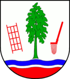
Blazon : "In silver over a red corrugated shield foot a narrow silver and a wide blue corrugated bar, above a green birch, on the right a red outwardly inclined peat baking pan, on the left a red peat quarry."
The red corrugated shield base of the coat of arms symbolizes the peat bog under the blue water areas, which stand for the large moor lakes and are characterized by the silver and blue wave bars. The peat baking pan and the peat scraper are historical tools used in wet peat extraction, which was carried out in the municipality until around 1960. Due to the geographic conditions, almost exclusively underwater peat extraction was carried out. The leafy downy birch with a green trunk is a typical tree of the area.
economy
In addition to agriculture and local recreation, there are some businesses in the municipality.
Web links
Individual evidence
- ↑ North Statistics Office - Population of the municipalities in Schleswig-Holstein 4th quarter 2019 (XLSX file) (update based on the 2011 census) ( help on this ).
- ↑ Schleswig-Holstein topography. Vol. 5: Holt - Krokau . 1st edition Flying-Kiwi-Verl. Junge, Flensburg 2005, ISBN 978-3-926055-79-8 , pp. 349 ( dnb.de [accessed on July 21, 2020]).
- ^ Election result Krempermoor
- ↑ Schleswig-Holstein's municipal coat of arms


