
Nienbüttel

| coat of arms | Germany map | |
|---|---|---|

|
Coordinates: 54 ° 2 ′ N , 9 ° 25 ′ E |
|
| Basic data | ||
| State : | Schleswig-Holstein | |
| Circle : | Stone castle | |
| Office : | Schenefeld | |
| Height : | 38 m above sea level NHN | |
| Area : | 4.16 km 2 | |
| Residents: | 127 (Dec. 31, 2019) | |
| Population density : | 31 inhabitants per km 2 | |
| Postal code : | 25596 | |
| Primaries : | 04827, 04892 | |
| License plate : | IZ | |
| Community key : | 01 0 61 076 | |
| LOCODE : | DE NNJ | |
| Office administration address: | Mühlenstrasse 2 25560 Schenefeld |
|
| Website : | ||
| Mayor : | Günter John (AWG) | |
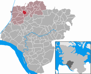
| Location of the municipality of Nienbüttel in the Steinburg district | ||
  |
||

Nienbüttel ( Low German : Nienbüddel ) is a municipality in the Steinburg district in Schleswig-Holstein . In terms of settlement history, it belongs to the Büttel localities.
Geography and traffic
Nienbüttel is about 3 km east of Wacken and 12 km north of Itzehoe on the federal highway 23 .
The district of Holstenbrook belongs to the municipality.
politics
Community representation
Since the municipal elections in 2013 , the AWG voter community has held all seven seats in the municipal council.
coat of arms
Blazon : "Divided by red and green by a lowered, slanting silver wavy bar, three silver thatched houses above, a silver plow below."
Web links
Individual evidence
- ↑ North Statistics Office - Population of the municipalities in Schleswig-Holstein 4th quarter 2019 (XLSX file) (update based on the 2011 census) ( help on this ).
- ↑ Schleswig-Holstein topography. Vol. 7: Munkbrarup - Pohnsdorf . 1st edition Flying-Kiwi-Verl. Junge, Flensburg 2006, ISBN 978-3-926055-88-0 , p. 112 ( dnb.de [accessed on July 22, 2020]).
- ↑ Schleswig-Holstein's municipal coat of arms
Carrion | Abbissinwish | Agethorst | Altenmoor | Auufer | Bahrenfleth | Beidenfleth | Bekdorf | Bekmünde | Besdorf | Blomean Wilderness | Bokelrehm | Bokhorst | Borsfleth | Breitenberg | Breitenburg | Brokdorf | Brokstedt | Büttel | Christinenthal | Dägeling | Dammfleth | Drage | Ecklak | Elskop | Engelbrecht Wilderness | Fitzbek | Glückstadt | Grevenkop | Gribbohm | Hadenfeld | Heiligenstedten | Heiligenstedtenerkamp | Hennstedt | Heart horn | Hingstheide | Hodorf | Hohenaspe | Hohenfelde | Hohenlockstedt | Holstenniendorf | Horst (Holstein) | Huje | Itzehoe | Kaaks | Kaisborstel | Kellinghusen | Lapwing row | Kleve | Kollmar | Kollmoor | Krempdorf | Brim | Kremperheide | Krempermoor | Kronsmoor | Krummendiek | Kudensee | Lägerdorf | Land law | Landscheide | Lockstedt | Lohbarbek | Looft | Mehlbek | Moordiek | Moorhusen | Mühlenbarbek | Münsterdorf | Neuenbrook | Neuendorf b. Elmshorn | Neuendorf-Sachsenbande | Nienbüttel | Nortorf | Nutteln | Oelixdorf | Oeschebüttel | Oldenborstel | Oldendorf | Ottenbüttel | Peissen | Pöschendorf | Poyenberg | Pulse | Quarnstedt | Wheel | Reher | Rethwisch | Rosdorf | Sankt Margarethen | Sarlhusen | Schenefeld | Schlotfeld | Silzen | Summer land | Stördorf | Störkathen | Süderau | Vaale | Vaalermoor | Wacken | Warring wood | Westermoor | Wewelsfleth | Wiedenborstel | Wills | Wilster | Winseldorf | Wittenbergen | Wrist | Wulfsmoor