
Krempau
| Krempau (Kremper Au) | ||
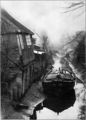
 Krempau at the road bridge (L 112) at the Steinburg in the district of the same name in the municipality of Süderau |
||
| Data | ||
| Water code | DE : 597698 | |
| location | Schleswig-Holstein , Germany | |
| River system | Elbe | |
| Drain over | Stör → Elbe → North Sea | |
| source | South of Brande-Hörnerkirchen | |
| muzzle | In the Stör coordinates: 53 ° 50 ′ 9 ″ N , 9 ° 26 ′ 10 ″ E 53 ° 50 ′ 9 ″ N , 9 ° 26 ′ 10 ″ E
|
|
| length | 20 km | |
The Krempau (also Kremper Au ) is a southern (left) tributary of the Stör in the Steinburg district or in the Kremper Marsch .
The Krempau is the last tributary of the Stör before it flows into the Elbe . It is approx. 20 km long or approx. 25 km including the underground sections and rises south of Brande-Hörnerkirchen in the Pinneberg district . From there it flows to the west, crosses under the A 23 between Hohenfelde and Steinburg , crosses under the L 112 in a southerly direction and then flows in a south-westerly direction through Süderauerdorf , Audorf and Süderau . From Süderau the Krempau flows in a north-westerly direction to Krempe , then makes an arc and flows again in a south-westerly direction along Krempdorf and Borsfletherbüttel , where it makes an arc to the north, flows through Borsfleth and finally flows into the Stör at river kilometer 75.8. In Borsfleth, the Krempau is separated from the Stör by the Verlathschleuse.
photos

The Verlathschleuse on the Krempau with a rest area

After the Verlathschleuse, the Stör has ebb

Kremper Au in brim


Former history
The Krempau originally ran through the middle of the town of Krempe, also right past the Krempe Town Hall . A non-original pulley is symbolically attached to the back of the town hall as a reminder that goods were also unloaded and stored there. The “Hohenfeld Umlaufkanal” was built in the south of the city as a result of the gradual siltation. After the original floodplain in the city area was filled in around 1960, two symbolic bridges still remind of the former course; Opposite Rathausstrasse No. 10 (pastorate) there is still an iron railing, the remainder of what were previously six crossings.
photos

Krempau flow 1652 in New country description by Danckwerth / Mejer
At the Krempau in Krempe at low tide (1908)

"Bridge near Göttsch": Rathausstr. (No. 10) / Breitestrasse ,

"Hohe Brücke": Rathausstr. (No. 34) / Breitestrasse , simulated railings are reminiscent of the old Krempau course


swell
- ↑ Archived copy ( memento of the original dated June 11, 2008 in the Internet Archive ) Info: The archive link was inserted automatically and has not yet been checked. Please check the original and archive link according to the instructions and then remove this notice.
- ^ "Kemper Au", colored postcard from 1904
- ↑ Krempau photo from 1925
- ↑ Ship unloading point on the Kremper Au
- ↑ Map of the former course of the Kremper Au
- ^ Granted in 1964
- ↑ old bridge railing "the former bridge near Göttsch"
- ↑ historical bridge name
- ↑ Name of the bridge in the Stadtboek, which was run from the 15th century
literature
- Klaus Bielenberg: The drainage system. The sturgeon. C. The Kremper Au. In: Heimatbuch -ommission (Hrsg.): Heimatbuch des Kreis Steinburg. Vol. 2, Augustin, Glückstadt 1925, pp. 312-320.
- Klaus-J. Lorenzen-Schmidt: The navigable tributaries of the sturgeon: Wilsterau, Kremperau and Breitenburger Kanal , in: Home association for the Steinburg district (ed.): Steinburger Yearbook 2011: The sturgeon in the Steinburg district , Itzehoe 2010, pp. 268–284.
Web links
- City of Krempe with six city history tours (including maps and images)