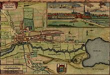
New country description of the two duchies of Schleswig and Holstein


The new state description of the two duchies of Schleswig and Holstein is an atlas of Schleswig-Holstein by the cartographer Johannes Mejer with descriptions of the country by Caspar Danckwerth . The work, which appeared in 1652, was commissioned by the Danish King Christian IV and Duke Friedrich III.
Origin and accuracy
Johannes Mejer acquired his cartographic knowledge in Copenhagen . For Duke Friedrich III. he created a map of the Aabenraa and the Schlei . On behalf of King Christian IV, Mejer began to record the west coast of Schleswig-Holstein in 1642 . In 1645 all of Schleswig-Holstein, Jutland and Denmark followed . Caspar Danckwerth wrote a description of the country and published the entire work, which consists of three volumes. The work contains a dedication sheet with a portrait and a dedication for each of the two named clients.
The map series represents the first large survey of the country . Mejer's maps are a very important source for the history of the country. The maps have a scale between approx. 1: 5,000 and 1: 50,000,000, and they can be used to reliably identify dike courses, roads, paths, places and landscapes. The positional accuracy of the drawn objects is limited. Errors of the order of magnitude of up to 2 km can certainly occur. The historicizing parts, for example the representation of the land losses of the Burchardi flood (or Second Grote Mandränke) in North Frisia in 1634 , are only partially correct. The city views are also only of limited use. The prints were later z. Partly colored by hand.
Detailed description
GH Burchard, Christian Rottgießer (engraver of the world map), Matthias Peters and Nicolaus Petersen (goldsmith and engraver from Husum) and Johann Holwein also worked on the work.
Ribbon, 34 x 8.5 x 49 cm; (three parts, 301 pages) and 40 maps with representations of the world map (division among Noah's descendants), of Germania with tribes (Central Europe and Scandinavia), the duchies of Schleswig and Holstein, their regions and offices and various city maps; regional history atlas.
Scale in German miles and (Rhenish) rods; Graduation for large-scale maps on the edge ( meridian grid on world map); Description of the country from the Flood to the present, with family tables of the dukes from different houses.
Among other things, the work contains maps and plans for: Schleswig-Holstein - Schleswig - Hadersleben - ground plan of the cities of Ribe, Hadersleben, Tondern, Husum and Tönning - Tondern - North Friesland - Aabenraa - Sonderburg - Flensburg - Helgoland - Schleswig - fishing and Schwansen - Gottorf - Husum - Eiderstedt - Dänischer Wold, Aröe, Fehmarn - Duchy of Holstein - The offices of Rendsburg, Kiel, Bordesholm, layout of the cities of Kiel, Rendsburg, Itzehoe and Oldesloe - Land of Wagrien - Principality of Stormarn - The offices of Trittau, Reinbek, Tremsbüttel and Steinhorst - Hamburg - County of Pinneberg - Steinburg, Kremper- and Wilstermarsch - Dithmarschen - Süderdithmarschen - Norderdithmarschen. Numerous smaller city maps are printed on the large maps.
Emphasis
In 1963, Kurt Domeier and Magdalene Haack published a reprint from Otto Heinevetter, Hamburg-Bergedorf, with the title Die Landkarten von Johannes Meyer, Husum, from Caspar Danckwerth's new description of the two duchies of Schleswig and Holstein, with an introduction by Christian Degn .
Spellings
The original spelling on the title page of the work has been changed so often when quoting the work that many different spellings are common:
- Newe Description of the country The two Hertduchess of Schleswig and Holstein , title from VD17
- New country description of the HERTZOGTÜHMER SCHLESWIG and HOLSTEIN
- New country description of the two duchies of Schleswig and Holstein
- Newe description of the country of the two duchies of Schleswig and Holstein
- Newe country description of the two duchies of Schleswig and Holstein
- Newe country description of the two Hertzogthiimer Schleswich and Holstein
- Newe description of the country of the two Hertzogthiimer Schleswig and Holstein
- Newe description of the country of the two Hertzogthiimer Schleswig-Holstein
- Newe description of the country of the two duchies of Schleswig and Holstein
- New country description of the two duchies of Schleswig and Holstein
- Newe description of the country of the duchies of Schleswig and Holstein
- New country description of the duchies of Schleswig and Holstein
- New country description of the duchies of Schleswig and Holstein
- Newe state description of the two duchies of Schleswig and Holstein
- Danckwerth Atlas
Web links
Individual evidence
- ↑ 23: 000620K in VD 17 .
