
Kaltenkirchen
| coat of arms | Germany map | |
|---|---|---|

|
Coordinates: 53 ° 50 ' N , 9 ° 58' E |
|
| Basic data | ||
| State : | Schleswig-Holstein | |
| Circle : | Segeberg | |
| Height : | 31 m above sea level NHN | |
| Area : | 23.1 km 2 | |
| Residents: | 22,109 (Dec. 31, 2019) | |
| Population density : | 957 inhabitants per km 2 | |
| Postal code : | 24568 | |
| Area code : | 04191 | |
| License plate : | SE | |
| Community key : | 01 0 60 044 | |
| LOCODE : | DE KKN | |
City administration address : |
Holstenstrasse 14 24568 Kaltenkirchen |
|
| Website : | ||
| Mayor : | Hanno Krause ( CDU ) | |
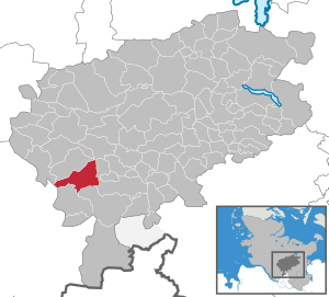
| Location of the city of Kaltenkirchen in the Segeberg district | ||
  |
||

_(12).jpg)

Kaltenkirchen ( Low German Koldenkarken ; colloquially Kaki ) is a town in the Segeberg district in Schleswig-Holstein . The districts of Moorkaten and Heidkaten are on the outskirts .
Geography and traffic
Kaltenkirchen is located 32 km north of Hamburg on the A 7 and on the local train line A 1 of the regional railway company AKN Eisenbahn GmbH .
Kaltenkirchen is the end point of the north development axis in the Hamburg metropolitan region as well as the middle center and has a total of four AKN railway stops: Kaltenkirchen Süd (industrial area), Kaltenkirchen (city center), Holstentherme (leisure park) and the Dodenhof stop .
It is planned to run the Hamburg S-Bahn on the AKN tracks from Hamburg to Kaltenkirchen in the medium term.
history
The city name is derived from the first written mention in the 14th century. The Middle Low German name of the settlement at that time was "Koldenkarken" or "Koldenkirchen". The current name has been used since 1701.
In 1884 Kaltenkirchen became the end point of a railway connection with Altona , which was later extended to Neumünster and was named Eisenbahn Altona-Kaltenkirchen-Neumünster (AKN).
In the Moorkaten district of the village of Kaltenkirchen there was an airfield of the Reichsluftwaffe and a satellite camp of the Neuengamme concentration camp for the accommodation of concentration camp prisoners who had to do forced labor during the expansion of the military airfield during the Second World War . Hundreds of prisoners were killed in the inhuman living and working conditions or were murdered by the guards. Since April 2000, is located on the site of the former Kaltenkirchen concentration camp outside the camp , the concentration camp memorial Kaltenkirchen in Spring Hirsch , reminiscent of the suffering of victims.
The former military airfield site in Moorkaten was after the Second World War by the Armed Forces as a training area used. This use has since been discontinued and the former training area is to be used as a compensation area for the expansion of the A 20 .
As a result of the Second World War, German refugees and displaced persons settled in Kaltenkirchen, whereby the population of the village increased two-and-a-half times from 1939 to 1946 to around 5000 people.
In the 1960s and 1970s, the major airport in Hamburg-Kaltenkirchen near Kaltenkirchen was planned to replace the airport in Hamburg-Fuhlsbüttel . These plans are currently not being pursued any further; However, Flughafen Hamburg GmbH , which is responsible for a possible construction, still has the necessary space in the Kaltenkirchener Heide and the planning was discussed again in 2003.
Kaltenkirchen received city rights on December 1, 1973 .

Fountain system

Old station building from 1884
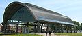
Roofing of the new (underground) Kaltenkirchen train station

.jpg)

politics
City council
Of the 35 seats in the city council, the CDU received eleven seats in the 2018 local elections. The SPD had eight, the Pro Kaki electoral community seven and the FDP five seats. The Left and the AfD each achieved two seats and are now part of the city council for the first time. The mayor is Hans-Jürgen Scheiwe (CDU). In August 2019, the CDU gained two seats by converting Pro Kaki.
mayor
The acting mayor has been Hanno Krause (CDU) since January 1, 2012 . In the mayoral election on May 7, 2017, he was confirmed in office with 88.6% of the votes cast.
coat of arms
The municipal coat of arms was designed by the Brunsbüttel heraldist Willy "Horsa" Lippert and the Kaltenkirchener Theodor Brix. The coat of arms was approved on July 18, 1974.
|
|
Blazon : "In red the silver , Holstein nettle leaf , on it a red church tower accompaniedby two blue oak leaves with a blue cap and a pointed tower ." |
| Foundation of the coat of arms: The landmark and oldest building of the town that became a town in 1973 is the St. Michaelis Church, represented in the coat of arms by its characteristic tower. At the same time, this stands as a representative part for the entire church building and thus refers “speaking” to the place name. The place and church were first mentioned in 1301, but both are undoubtedly older. As is known from the neighboring parish of Bramstedt, the history of the parish of Kaltenkirchen probably began before the 13th century. Prehistoric burial mounds with urn finds indicate a settlement continuity reaching back even further. The oak leaves in the coat of arms are intended to remind of the former forest area in which the place was created. To make it clear that the city belongs to the Holstein region, the local symbol is drawn in the oversized nettle leaf. Nowadays, the modern city takes advantage of its favorable location near the greater Hamburg area. The affiliation to the federal state Schleswig-Holstein is documented by the coat of arms colors blue, silver and red. |
flag
The flag was approved on May 8, 1978.
In the middle of a white cloth, shifted a little towards the pole, the city coat of arms is accompanied by a red stripe at the top and bottom near the edge.
Town twinning
-
 Kalisz Pomorski (Kallies) in Poland , since 1999
 -
 Putlitz in Brandenburg , since 1990
 -
 Aabenraa (Aabenraa), as the successor to the dissolved Rothenkrug / Rødekro municipality in North Schleswig / Denmark
Culture and sights
Buildings
- The large housing estate "Großer Karl" played an important role in the scandal surrounding the former Holstein real estate mogul Gerd Thormählen.
Cultural monuments
According to the city administration, Kaltenkirchen has no distinct tourist ambience, only little tourism and only a few cultural monuments. In the 1970s, many old buildings were torn down, especially thatched - half-timbered houses . An example of this nearly vanished design is still the so-called community center , which was rebuilt after an arson attack 2,001th One building that has always been threatened with demolition is the old station building from 1884, near which the new Kaltenkirchen tunnel station was built. It was renovated in 2016.
Leisure and recreation
The city has an adventure pool with an attached sauna area and fitness studio . In addition, Kaltenkirchen has an approximately 2000 m² warm water outdoor pool , which was built in 1999 and is located next to the Holstentherme adventure pool .
sports clubs
The following sports clubs are active in Kaltenkirchen: Kaltenkirchener Turnerschaft (KT), Association for Rehabilitation and Fitness Kaltenkirchen (REHA-FIT Kaltenkirchen for short), FSC Kaltenkirchen, Fetihspor Kaltenkirchen, TC an der Schirnau, Schachklub Kaltenkirchen, MSC Kaltenkirchen, Schützenverein Kaltenkirchen, Radsportclub Kattenberg, Canoe Club Kaltenkirchen, Kaltenkirchen bowling club, Moo Rim San (Taekwondo) and MoSan.
religion
Kaltenkirchen has almost 22,000 inhabitants, of which around 9,500 are Protestant parishioners.
economy
The economy of Kaltenkirchen is characterized by a furniture and equipment store, the food industry and a building material manufacturer. The regional railway company AKN Eisenbahn GmbH, which operates routes in southern Schleswig-Holstein and parts of Hamburg, has its administrative headquarters and workshops in Kaltenkirchen.
See also: Category: Kaltenkirchen
fire Department
The voluntary fire brigade of the city of Kaltenkirchen was founded on November 9th, 1888 by 33 citizens of Kaltenkirchen. It is the successor to a coercive defense and has set itself the task of unselfishly helping other people for the benefit of fellow citizens.
The Kaltenkirchen fire brigade has had its location in Kisdorf since 1974. In 2014 it was decided to build a new guard. A new guard was built on Süderstrasse. The inauguration ceremony of the new fire station took place on October 21, 2016. The new guard has a vehicle hall with 16 parking spaces and an area of approx. 1,464 m².
The youth fire brigade, which was founded in 1977, plays a major role in the defense, as young firefighters continuously transfer to the active defense.
The Kaltenkirchen fire brigade has a total of 15 emergency vehicles. This means that the fire brigade has the right device for various deployment scenarios.
schools

There are three primary schools in Kaltenkirchen :
- Primary school on Lakweg
- Primary school Alter Landweg
- Flottkamp primary school
two special schools :
- Janusz Korczak School
- Special school on Lakweg
two community schools :
- Community school on Marschweg
- Dietrich Bonhoeffer School
a high school :
- Kaltenkirchen high school
a Waldorf school :
- Free Waldorf School Kaltenkirchen
as well as a private school:
- Leibniz private school
Personalities
sons and daughters of the town
- Rudolf Timm (1901–1934), political functionary (KPD) and Nazi victim
- Herbert Timm (1911–1987), finance scientist and university professor
- Ursula Paulsen (* 1935), table tennis player
- Manfred Dietrich (* 1944), Lieutenant General, Deputy Inspector of the Army (2001-2005)
- Thorsten Wahlers (* 1958), cardiac surgeon
- Bernd Kortmann (* 1960), linguist and director of FRIAS
- Aaron Ziercke (* 1972), handball player and handball trainer
- Jan Schiffers (* 1977), politician (AfD)
- Jan Hartmann (* 1980), actor
- Maike Schirmer (* 1990), handball player
- Marcus Spiegelberg (* 1992), politician (AfD)
- Manuel Farrona Pulido (* 1993), football player
- Jonas Behounek (* 1998), soccer player
People who worked on site
- Hans Stockmar (1890–1961), entrepreneur, founded Hans Stockmar GmbH & Co. KG in Kaltenkirchen
- Ernst Biberstein (1899–1986), Protestant pastor, SS-Obersturmbannführer, was a pastor in Kaltenkirchen
- Heinz Friedrich Kamecke (1902–1982), journalist and writer, lived in Kaltenkirchen
- Bengta Bischoff (1909–1987), novelist, died in Kaltenkirchen
- Uwe Amthor (* 1945), grammar school teacher and politician (SPD), lives in Kaltenkirchen
- Katharina Loedige (* 1962), politician (FDP), lives in Kaltenkirchen
- Hanno Krause (* 1964), politician (CDU), mayor of the city of Kaltenkirchen
- Beatrix von Storch (* 1971), politician (AfD), graduated from high school in Kaltenkirchen
- Jörg Nobis (* 1975), politician (AfD), lives in Kaltenkirchen
- Björn Dreyer (* 1977), soccer player, was a trainer in Kaltenkirchen
literature
- Gerhard Hoch : Twelve rediscovered years. Kaltenkirchen under the swastika . Verlag Roland-Werbung, Bad Bramstedt 1980; Reprint: Ed .: Kaltenkirchen concentration camp memorial association in Springhirsch e. V. Books on Demand, Norderstedt 2006, ISBN 3-8334-4271-9 .
- Helmut Münker among others: Kaltenkirchen through the ages. The development of the city in old and new images . Evert, Neumünster 1993.
- Karl-Michael Schroeder: Kaltenkirchen: village and city stories . EPV, Duderstadt 2011, ISBN 978-3-936318-87-6 .
- Helmut Trede: From prison camp to international airport - a chronology of failure, Lentföhrden - Hamburg-Kaltenkirchen, self-published 2013, ISBN 978-3-00-044299-5 .
Web links
Individual evidence
- ↑ North Statistics Office - Population of the municipalities in Schleswig-Holstein 4th quarter 2019 (XLSX file) (update based on the 2011 census) ( help on this ).
- ↑ Schleswig-Holstein topography. Vol. 5: Holt - Krokau . 1st edition Flying-Kiwi-Verl. Junge, Flensburg 2005, ISBN 978-3-926055-79-8 , pp. 148 ( dnb.de [accessed on July 20, 2020]).
- ↑ Five points why the S-Bahn can get to Kaltenkirchen safely. ( Memento from October 18, 2014 in the Internet Archive ) In: Hamburg local transport website. Retrieved October 13, 2014.
- ^ Website of the Kaltenkirchen concentration camp memorial in Springhirsch . Retrieved February 9, 2011
- ↑ History trail becomes more likely. Almost 4,000 visitors to the Springhirsch memorial. ( Memento from March 4, 2016 in the Internet Archive )
- ^ Peter Zerbe, Oliver Schirg: Hamburg: Large airport planned in Kaltenkirchen. In: Internet site Die Welt . October 15, 2003, accessed February 9, 2011 .
- ^ Federal Statistical Office (ed.): Historical municipality directory for the Federal Republic of Germany. Name, border and key number changes in municipalities, counties and administrative districts from May 27, 1970 to December 31, 1982 . W. Kohlhammer, Stuttgart / Mainz 1983, ISBN 3-17-003263-1 , p. 186 .
- ↑ CDU wins local election. In: Kiel News . Retrieved September 12, 2018 .
- ^ City of Kaltenkirchen: mayor. In: Website of the city of Kaltenkirchen. Retrieved September 12, 2018 .
- ↑ Because of the motocross facility for the CDU. In: Pro Kaki website. Retrieved February 20, 2020 .
- ↑ a b Schleswig-Holstein's municipal coat of arms
- ↑ main statute. (PDF; 115 KB) § 1; Coat of arms, flag, seal (§ 12 GO), paragraph 1. In: Website of the city of Kaltenkirchen. February 16, 2017, p. 2 , accessed August 15, 2019 .
- ↑ main statute. (PDF; 115 KB) § 1; Coat of arms, flag, seal (§ 12 GO), paragraph 2. In: Website of the city of Kaltenkirchen. February 16, 2017, p. 2 , accessed August 15, 2019 .
- ^ Evangelical Church Kaltenkirchen
- ↑ Kaltenkirchen Volunteer Fire Brigade - new guard building. January 9, 2016, accessed November 25, 2019 (German).
Alveslohe | Armstedt | Bad Bramstedt | Bad Segeberg | Bahrenhof | Bark | Bebensee | Bimöhlen | Blunk | Boostedt | Bornhöved | Borstel | Bühnsdorf | Daldorf | Damsdorf | Dreggers | Ellerau | Fahrenkrug | Föhrden-Barl | Fredesdorf | Fuhlendorf | Geschendorf | Glasau | Gönnebek | Groß Kummerfeld | Gross Niendorf | Groß Rönnau | Great Aspen | Hagen | Hardebek | Hartenholm | Hasenkrug | Rabbit Moor | Heidmoor | Heidmühlen | Henstedt-Ulzburg | Hitzhusen | Högersdorf | Hüttblek | Itzstedt | Kaltenkirchen | Kattendorf | Kayhude | Kisdorf | Klein Gladebrugge | Klein Rönnau | Krems II | Kükels | Latendorf | Leezen | Lentföhrden | Mönkloh | Mözen | Near | Negro Bay | Take | Neuengörs | Neversdorf | Norderstedt | Use | Oering | Oersdorf | Pronstorf | Rickling | Rohlstorf | Schackendorf | Sheer | Schmalensee | Narrow field | Schwissel | Seedorf | Seth | Sievershütten | Stipsdorf | Stocksee | Strukdorf | Struvenhütten | Stuvenborn | Sülfeld | Tarbek | Tensfeld | Fields of death | Trappenkamp | Travenhorst | Traventhal | Wahlstedt | Wakendorf I | Wakendorf II | Weddelbrook | Weede | Wensin | Westerrade | Wiemersdorf | Winsen | Wittenborn
Non-parish area in the Segeberg
forest district of Buchholz