
Latendorf
| coat of arms | Germany map | |
|---|---|---|

|
Coordinates: 54 ° 0 ' N , 10 ° 4' E |
|
| Basic data | ||
| State : | Schleswig-Holstein | |
| Circle : | Segeberg | |
| Office : | Boostedt-Rickling | |
| Height : | 42 m above sea level NHN | |
| Area : | 17.94 km 2 | |
| Residents: | 606 (Dec. 31, 2019) | |
| Population density : | 34 inhabitants per km 2 | |
| Postal code : | 24598 | |
| Primaries : | 04320, 04393 | |
| License plate : | SE | |
| Community key : | 01 0 60 052 | |
| Office administration address: | Twiete 9 24598 Boostedt |
|
| Website : | ||
| Mayor : | Torsten Hamann (WLB) | |
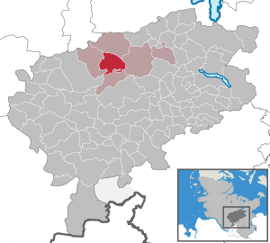
| Location of the municipality of Latendorf in the Segeberg district | ||
  |
||

Latendorf is a municipality in the Segeberg district in Schleswig-Holstein . Braak and Braak settlement are in the municipality.
Geography and traffic
Latendorf is located about 10 km southeast of Neumünster , 15 km northeast of Bad Bramstedt and 16 km northwest of Bad Segeberg on the edge of the Segeberger Forest . To the northeast, the federal highway 205 runs from Bad Segeberg to Neumünster, south the federal highway 206 from Bad Segeberg to Bad Bramstedt and to the west the federal highway 7 from Hamburg to Schleswig .
politics
Community representation
Of the nine seats in the municipal council has Wählergemeinschaft WLB since the municipal election in 2018 seven seats and the CDU has two seats. The SPD did not run for the 2013 local elections.
coat of arms
Blazon : “Divided by silver and green in the graft cut with three flat plugs lowered. Above two upright green deciduous branches, below a silver deer antler. "
economy
The municipality is structured agriculturally.
Personalities
From 1958 the writer Hinrich Kruse (1916–1994), also known as a Low German radio play author, lived and worked in Braak.
Web links
Individual evidence
- ↑ North Statistics Office - Population of the municipalities in Schleswig-Holstein 4th quarter 2019 (XLSX file) (update based on the 2011 census) ( help on this ).
- ↑ Schleswig-Holstein topography. Vol. 6: Kronprinzenkoog - Mühlenrade . 1st edition Flying-Kiwi-Verl. Junge, Flensburg 2006, ISBN 978-3-926055-85-9 , pp. 118 ( dnb.de [accessed on July 24, 2020]).
- ↑ Schleswig-Holstein's municipal coat of arms
Alveslohe | Armstedt | Bad Bramstedt | Bad Segeberg | Bahrenhof | Bark | Bebensee | Bimöhlen | Blunk | Boostedt | Bornhöved | Borstel | Bühnsdorf | Daldorf | Damsdorf | Dreggers | Ellerau | Fahrenkrug | Föhrden-Barl | Fredesdorf | Fuhlendorf | Geschendorf | Glasau | Gönnebek | Groß Kummerfeld | Gross Niendorf | Groß Rönnau | Great Aspen | Hagen | Hardebek | Hartenholm | Hasenkrug | Rabbit Moor | Heidmoor | Heidmühlen | Henstedt-Ulzburg | Hitzhusen | Högersdorf | Hüttblek | Itzstedt | Kaltenkirchen | Kattendorf | Kayhude | Kisdorf | Klein Gladebrugge | Klein Rönnau | Krems II | Kükels | Latendorf | Leezen | Lentföhrden | Mönkloh | Mözen | Near | Negro Bay | Take | Neuengörs | Neversdorf | Norderstedt | Use | Oering | Oersdorf | Pronstorf | Rickling | Rohlstorf | Schackendorf | Sheer | Schmalensee | Narrow field | Schwissel | Seedorf | Seth | Sievershütten | Stipsdorf | Stocksee | Strukdorf | Struvenhütten | Stuvenborn | Sülfeld | Tarbek | Tensfeld | Fields of death | Trappenkamp | Travenhorst | Traventhal | Wahlstedt | Wakendorf I | Wakendorf II | Weddelbrook | Weede | Wensin | Westerrade | Wiemersdorf | Winsen | Wittenborn
Non-parish area in the Segeberg
forest district of Buchholz