
Glasau
| coat of arms | Germany map | |
|---|---|---|

|
Coordinates: 54 ° 3 ' N , 10 ° 31' E |
|
| Basic data | ||
| State : | Schleswig-Holstein | |
| Circle : | Segeberg | |
| Office : | Trave land | |
| Height : | 42 m above sea level NHN | |
| Area : | 18.82 km 2 | |
| Residents: | 874 (Dec. 31, 2019) | |
| Population density : | 46 inhabitants per km 2 | |
| Postal code : | 23719 | |
| Primaries : | 04525/04527 | |
| License plate : | SE | |
| Community key : | 01 0 60 025 | |
| LOCODE : | DE 62G | |
| Office administration address: | Waldemar-von-Mohl-Strasse 10 23795 Bad Segeberg |
|
| Website : | ||
| Mayor : | Henning Frahm ( CDU ) | |
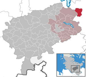
| Location of the community Glasau in the Segeberg district | ||
  |
||


Glasau is a municipality in the Segeberg district in Schleswig-Holstein . Altenweide, Kambeck, Neuglasau and Sarau are in the municipality.
history
A satellite camp of the Neuengamme concentration camp was located near the community from March 27 to May 5, 1945 . The camp is listed as number 466 in the directory of concentration camps and their external units.

In 1979 and 1982 the community was the district winner in the competition Our village should become more beautiful .
geography
Glasau is located about ten kilometers southwest of Eutin and 18 kilometers northeast of Bad Segeberg in Holstein Switzerland .
politics
Community representation
Of the eleven seats in the municipal council, the CDU has had six seats since the 2018 local elections, the SPD one and the WGG-S electoral community four.
coat of arms
Blazon : "In green a silver drawbar, only in the upper corner reaching to the head of the shield red flames in silver, at right angles two silver stones, in the left corner a growing golden crook."
Economy and Infrastructure
Tourism is becoming an important source of income for the community.
The federal highway 432 runs south of Glasau from Bad Segeberg to Scharbeutz , north the federal highway 76 runs from Eutin to Plön .
Attractions
The list of cultural monuments in Glasau includes the cultural monuments entered in the list of monuments of Schleswig-Holstein.
Gut Glasau, whose manor house was built in the English style in 1912, is owned by the von Hoff family and is used as a farm.
The Sarau Church is the second church on the site and was built after 1629, the tower was built in 1865. It is a single-nave hall church made of red brick, about 35 m long and about 15 m wide.
The Thing Oak Sarau is located at the place used as a Thing site before 1109, where the Sarau Church was later built, and is marked by a stone with the inscription "Thinkplatz vor 1109".
literature
- Lund, Georg: Glasow, Sarowe, Smachthagen. A chronicle, Wäser Verlag Bad Segeberg 1980
Web links
Individual evidence
- ↑ North Statistics Office - Population of the municipalities in Schleswig-Holstein 4th quarter 2019 (XLSX file) (update based on the 2011 census) ( help on this ).
- ↑ Schleswig-Holstein topography. Vol. 3: Ellerbek - Groß Rönnau . 1st edition Flying-Kiwi-Verl. Junge, Flensburg 2003, ISBN 978-3-926055-73-6 , p. 223 ( dnb.de [accessed on April 22, 2020]).
- ^ Directory of the concentration camps and their external commands in accordance with Section 42 (2) BEG
- ↑ Schleswig-Holstein's municipal coat of arms
Alveslohe | Armstedt | Bad Bramstedt | Bad Segeberg | Bahrenhof | Bark | Bebensee | Bimöhlen | Blunk | Boostedt | Bornhöved | Borstel | Bühnsdorf | Daldorf | Damsdorf | Dreggers | Ellerau | Fahrenkrug | Föhrden-Barl | Fredesdorf | Fuhlendorf | Geschendorf | Glasau | Gönnebek | Groß Kummerfeld | Gross Niendorf | Groß Rönnau | Great Aspen | Hagen | Hardebek | Hartenholm | Hasenkrug | Rabbit Moor | Heidmoor | Heidmühlen | Henstedt-Ulzburg | Hitzhusen | Högersdorf | Hüttblek | Itzstedt | Kaltenkirchen | Kattendorf | Kayhude | Kisdorf | Klein Gladebrugge | Klein Rönnau | Krems II | Kükels | Latendorf | Leezen | Lentföhrden | Mönkloh | Mözen | Near | Negro Bay | Take | Neuengörs | Neversdorf | Norderstedt | Use | Oering | Oersdorf | Pronstorf | Rickling | Rohlstorf | Schackendorf | Sheer | Schmalensee | Narrow field | Schwissel | Seedorf | Seth | Sievershütten | Stipsdorf | Stocksee | Strukdorf | Struvenhütten | Stuvenborn | Sülfeld | Tarbek | Tensfeld | Fields of death | Trappenkamp | Travenhorst | Traventhal | Wahlstedt | Wakendorf I | Wakendorf II | Weddelbrook | Weede | Wensin | Westerrade | Wiemersdorf | Winsen | Wittenborn
Non-parish area in the Segeberg
forest district of Buchholz