Schieren (Segeberg district)
| coat of arms | Germany map | |
|---|---|---|

|
Coordinates: 53 ° 57 ' N , 10 ° 24' E |
|
| Basic data | ||
| State : | Schleswig-Holstein | |
| Circle : | Segeberg | |
| Office : | Trave land | |
| Height : | 40 m above sea level NHN | |
| Area : | 6.36 km 2 | |
| Residents: | 260 (Dec. 31, 2019) | |
| Population density : | 41 inhabitants per km 2 | |
| Postal code : | 23795 | |
| Area code : | 04551 | |
| License plate : | SE | |
| Community key : | 01 0 60 071 | |
| Office administration address: | Waldemar-von-Mohl-Strasse 10 23795 Bad Segeberg |
|
| Website : | ||
| Mayor : | Hans-Werner Schumacher (WfS) | |
| Location of the community of Schieren in the Segeberg district | ||
Schieren is a municipality in the Segeberg district in Schleswig-Holstein .
Geography and traffic
Schieren is located about 6 km east of Bad Segeberg in a rural area near Lake Wardersee . The federal highway 206 runs south from Bad Segeberg to Lübeck , north the federal highway 432 runs from Bad Segeberg to Scharbeutz . The place is laid out as a round .
history
Archaeological finds prove a settlement in the Neolithic .
Schieren was first mentioned in 1342 as "Schire" and was located in the border area between the Saxons and the Slavs . In 1871 a peace oak was planted in the middle of the village.
politics
Community representation
Of the nine seats in the municipal council, the community of voters AS has five seats since the local elections in 2008 and the community of voters of the KWG four.
coat of arms
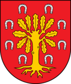
Blazon : "A golden oak tree with roots in red, the crown of which is surrounded by eight silver horseshoes."
economy
The municipal area is predominantly agricultural, but there are also some businesses.
Web links
Individual evidence
- ↑ North Statistics Office - Population of the municipalities in Schleswig-Holstein 4th quarter 2019 (XLSX file) (update based on the 2011 census) ( help on this ).
- ↑ Schleswig-Holstein's municipal coat of arms


