
Lentföhrden
| coat of arms | Germany map | |
|---|---|---|

|
Coordinates: 53 ° 52 ' N , 9 ° 53' E |
|
| Basic data | ||
| State : | Schleswig-Holstein | |
| Circle : | Segeberg | |
| Office : | Kaltenkirchen-Land | |
| Height : | 23 m above sea level NHN | |
| Area : | 20.07 km 2 | |
| Residents: | 2682 (Dec. 31, 2019) | |
| Population density : | 134 inhabitants per km 2 | |
| Postcodes : | 24632, 24640 | |
| Primaries : | 04191, 04192 | |
| License plate : | SE | |
| Community key : | 01 0 60 054 | |
| LOCODE : | DE 59I | |
| Office administration address: | Schmalfelder Strasse 9 24568 Kaltenkirchen |
|
| Website : | ||
| Mayor : | † Norbert Dähling (WGL) | |
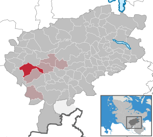
| Location of the municipality of Lentföhrden in the Segeberg district | ||
  |
||

Lentföhrden is a municipality in the Segeberg district in Schleswig-Holstein . Waldberg and Lohn are in the municipality.
Geography and traffic

Lentföhrden is located in an extensive moor and heather area, which has, however, been partially afforested.
The community is located north of Hamburg on federal highway 4 between the cities of Bad Bramstedt and Kaltenkirchen . Alternatively, Lentföhrden can be reached via the federal motorway 7, exit Kaltenkirchen. On infrastructure, the municipality is on the railway line Hamburg-Altona-Kaltenkirchen-Neumünster the AKN reach.
In the course of the planned expansion of the Baltic Sea motorway, Lentföhrden will also be accessible via the federal motorway 20 . The junction is expected to be built north of the community in the direction of Bad Bramstedt .
history
Lentföhrden was first mentioned in a document in 1479. The Ochsenweg and the Altona-Kieler Chaussee ran through the municipality . This approx. 94 km long road was built between 1830 and 1832 by the then King Friedrich VI. built by Denmark.
politics
Community representation
Of the thirteen seats in the municipal council, the Lentföhrden voter community (WGL) has five seats, the SPD and CDU each have four seats.
coat of arms
Blazon : "A courting black grouse in silver, inspired by the natural coloring of black, gold and red."
Attractions
The list of cultural monuments in Lentföhrden includes the cultural monuments entered in the list of monuments of Schleswig-Holstein.
Economy and Infrastructure
The municipality is predominantly agricultural. In the course of the discussion about the construction of the Kaltenkirchen airport , which was not implemented, several residential areas were created in Lentföhrden.
In Lentföhrden there is a retirement and nursing home, a kindergarten, a primary school with a sports hall as well as a youth and cultural center and an outdoor pool.
Most of the village has had a fiber optic network since 2013 . The underlying technology is based on Fiber to the Home . Most parts of Lentföhrden are built over with VDSL100.
literature
- Helmut Trede: From prison camp to international airport - a chronology of failure, Lentföhrden - Hamburg-Kaltenkirchen, self-published 2013, ISBN 978-3-00-044299-5 .
- Peter Vollmer: Just for one night? Mesolithic hunters near Lentföhrden, Segeberg district In: Archäologische Nachrichten aus Schleswig-Holstein 2011 ISBN 978-3-529-01433-8 pp. 19-21
Web links
Individual evidence
- ↑ North Statistics Office - Population of the municipalities in Schleswig-Holstein 4th quarter 2019 (XLSX file) (update based on the 2011 census) ( help on this ).
- ↑ Schleswig-Holstein topography. Vol. 6: Kronprinzenkoog - Mühlenrade . 1st edition Flying-Kiwi-Verl. Junge, Flensburg 2006, ISBN 978-3-926055-85-9 , pp. 148 ( dnb.de [accessed on July 25, 2020]).
- ↑ Schleswig-Holstein's municipal coat of arms
Alveslohe | Armstedt | Bad Bramstedt | Bad Segeberg | Bahrenhof | Bark | Bebensee | Bimöhlen | Blunk | Boostedt | Bornhöved | Borstel | Bühnsdorf | Daldorf | Damsdorf | Dreggers | Ellerau | Fahrenkrug | Föhrden-Barl | Fredesdorf | Fuhlendorf | Geschendorf | Glasau | Gönnebek | Groß Kummerfeld | Gross Niendorf | Groß Rönnau | Great Aspen | Hagen | Hardebek | Hartenholm | Hasenkrug | Rabbit Moor | Heidmoor | Heidmühlen | Henstedt-Ulzburg | Hitzhusen | Högersdorf | Hüttblek | Itzstedt | Kaltenkirchen | Kattendorf | Kayhude | Kisdorf | Klein Gladebrugge | Klein Rönnau | Krems II | Kükels | Latendorf | Leezen | Lentföhrden | Mönkloh | Mözen | Near | Negro Bay | Take | Neuengörs | Neversdorf | Norderstedt | Use | Oering | Oersdorf | Pronstorf | Rickling | Rohlstorf | Schackendorf | Sheer | Schmalensee | Narrow field | Schwissel | Seedorf | Seth | Sievershütten | Stipsdorf | Stocksee | Strukdorf | Struvenhütten | Stuvenborn | Sülfeld | Tarbek | Tensfeld | Fields of death | Trappenkamp | Travenhorst | Traventhal | Wahlstedt | Wakendorf I | Wakendorf II | Weddelbrook | Weede | Wensin | Westerrade | Wiemersdorf | Winsen | Wittenborn
Non-parish area in the Segeberg
forest district of Buchholz