
Wittenborn
| coat of arms | Germany map | |
|---|---|---|

|
Coordinates: 53 ° 56 ' N , 10 ° 14' E |
|
| Basic data | ||
| State : | Schleswig-Holstein | |
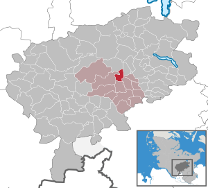
| Circle : | Segeberg | |
| Office : | Leezen | |
| Height : | 38 m above sea level NHN | |
| Area : | 6.19 km 2 | |
| Residents: | 975 (Dec. 31, 2019) | |
| Population density : | 158 inhabitants per km 2 | |
| Postal code : | 23829 | |
| Area code : | 04554 | |
| License plate : | SE | |
| Community key : | 01 0 60 101 | |
| LOCODE : | DE WR4 | |
| Office administration address: | Hamburger Strasse 28 23816 Leezen |
|
| Website : | ||
| Mayor : | Thorsten Lange ( CDU ) | |
| Location of the municipality of Wittenborn in the Segeberg district | ||
  |
||

Wittenborn is a municipality in the Segeberg district in Schleswig-Holstein .
geography
Wittenborn lies on the edge of the Segeberger Forest , near the Mözener See .
history
Megalithic tombs in the municipality, such as the Wittenborn dolmen, indicate prehistoric settlement. There are a total of about 60 archaeological sites from the Neolithic to the Roman Empire in the community, which also contain urn cemeteries and settlement remains.
The place was first mentioned in 1139 as Wittenburna . At that time it belonged to the Segeberg monastery . The municipality has existed in its current form since 1867.
politics
coat of arms
Blazon : "Split by blue and silver, covered with a fountain made of ashlar with a wide rim in mixed up colors."
economy
Due to its proximity to the Mözener See and the Segeberger Forest, Wittenborn is a popular destination. There are two campsites and a large industrial area in the municipality.
Sons and daughters (selection)
- Paul Könke (1870-19?), Politician (DDP), member of the Reichstag
photos
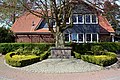
Cenotaph for the dead of the world wars

Wittenborner Heide nature reserve


Web links
Individual evidence
- ↑ North Statistics Office - Population of the municipalities in Schleswig-Holstein 4th quarter 2019 (XLSX file) (update based on the 2011 census) ( help on this ).
- ↑ Schleswig-Holstein's municipal coat of arms
Alveslohe | Armstedt | Bad Bramstedt | Bad Segeberg | Bahrenhof | Bark | Bebensee | Bimöhlen | Blunk | Boostedt | Bornhöved | Borstel | Bühnsdorf | Daldorf | Damsdorf | Dreggers | Ellerau | Fahrenkrug | Föhrden-Barl | Fredesdorf | Fuhlendorf | Geschendorf | Glasau | Gönnebek | Groß Kummerfeld | Gross Niendorf | Groß Rönnau | Great Aspen | Hagen | Hardebek | Hartenholm | Hasenkrug | Rabbit Moor | Heidmoor | Heidmühlen | Henstedt-Ulzburg | Hitzhusen | Högersdorf | Hüttblek | Itzstedt | Kaltenkirchen | Kattendorf | Kayhude | Kisdorf | Klein Gladebrugge | Klein Rönnau | Krems II | Kükels | Latendorf | Leezen | Lentföhrden | Mönkloh | Mözen | Near | Negro Bay | Take | Neuengörs | Neversdorf | Norderstedt | Use | Oering | Oersdorf | Pronstorf | Rickling | Rohlstorf | Schackendorf | Sheer | Schmalensee | Narrow field | Schwissel | Seedorf | Seth | Sievershütten | Stipsdorf | Stocksee | Strukdorf | Struvenhütten | Stuvenborn | Sülfeld | Tarbek | Tensfeld | Fields of death | Trappenkamp | Travenhorst | Traventhal | Wahlstedt | Wakendorf I | Wakendorf II | Weddelbrook | Weede | Wensin | Westerrade | Wiemersdorf | Winsen | Wittenborn
Non-parish area in the Segeberg
forest district of Buchholz