
Oering
| coat of arms | Germany map | |
|---|---|---|

|
Coordinates: 53 ° 50 ' N , 10 ° 9' E |
|
| Basic data | ||
| State : | Schleswig-Holstein | |
| Circle : | Segeberg | |
| Office : | Itzstedt | |
| Height : | 36 m above sea level NHN | |
| Area : | 9.09 km 2 | |
| Residents: | 1382 (December 31, 2019) | |
| Population density : | 152 inhabitants per km 2 | |
| Postal code : | 23845 | |
| Area code : | 04535 | |
| License plate : | SE | |
| Community key : | 01 0 60 065 | |
| Office administration address: | Segeberger Strasse 41 23845 Itzstedt |
|
| Website : | ||
| Mayor : | Bodo Nagel (WGO) | |
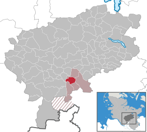
| Location of the municipality of Oering in the Segeberg district | ||
  |
||

Oering is a municipality in the Segeberg district in Schleswig-Holstein .
Geography and traffic
Oering is located about 17 km northeast of Norderstedt near the federal highway 432 between Hamburg and Bad Segeberg . The L 80 runs through the village, which leads from the L 234 in Kaltenkirchen to the B 432 near Oering.
history
The place originally belonged to Gut Borstel , which today belongs to the municipality of Sülfeld .
politics
Community representation
Of the thirteen seats in the municipal council, the Oering voter community (WGO) has had seven seats since the 2013 local elections, the CDU four and the FDP two.
coat of arms
Blazon : "In green a flat, silver wavy cap, accompanied on the right and left by a golden linden leaf sloping outwards and below by a golden ring segmented seven times."
economy
The municipality is predominantly agricultural. The two largest companies are two mills / land trade , the Oeringer Mühle and ATR. In addition to some handicraft businesses and other commercial and service companies, the letter and freight post center 24 of Deutsche Post AG is located in the village. Other companies wanted to settle there, but no commercial space was available.
In October 2008 it was decided to build a fiber optic network and in 2010 all households were connected.
Web links
Individual evidence
- ↑ North Statistics Office - Population of the municipalities in Schleswig-Holstein 4th quarter 2019 (XLSX file) (update based on the 2011 census) ( help on this ).
- ↑ Schleswig-Holstein's municipal coat of arms
Alveslohe | Armstedt | Bad Bramstedt | Bad Segeberg | Bahrenhof | Bark | Bebensee | Bimöhlen | Blunk | Boostedt | Bornhöved | Borstel | Bühnsdorf | Daldorf | Damsdorf | Dreggers | Ellerau | Fahrenkrug | Föhrden-Barl | Fredesdorf | Fuhlendorf | Geschendorf | Glasau | Gönnebek | Groß Kummerfeld | Gross Niendorf | Groß Rönnau | Great Aspen | Hagen | Hardebek | Hartenholm | Hasenkrug | Rabbit Moor | Heidmoor | Heidmühlen | Henstedt-Ulzburg | Hitzhusen | Högersdorf | Hüttblek | Itzstedt | Kaltenkirchen | Kattendorf | Kayhude | Kisdorf | Klein Gladebrugge | Klein Rönnau | Krems II | Kükels | Latendorf | Leezen | Lentföhrden | Mönkloh | Mözen | Near | Negro Bay | Take | Neuengörs | Neversdorf | Norderstedt | Use | Oering | Oersdorf | Pronstorf | Rickling | Rohlstorf | Schackendorf | Sheer | Schmalensee | Narrow field | Schwissel | Seedorf | Seth | Sievershütten | Stipsdorf | Stocksee | Strukdorf | Struvenhütten | Stuvenborn | Sülfeld | Tarbek | Tensfeld | Fields of death | Trappenkamp | Travenhorst | Traventhal | Wahlstedt | Wakendorf I | Wakendorf II | Weddelbrook | Weede | Wensin | Westerrade | Wiemersdorf | Winsen | Wittenborn
Non-parish area in the Segeberg
forest district of Buchholz