
Vollerwiek
| coat of arms | Germany map | |
|---|---|---|

|
Coordinates: 54 ° 17 ' N , 8 ° 48' E |
|
| Basic data | ||
| State : | Schleswig-Holstein | |
| Circle : | North Friesland | |
| Office : | Eiderstedt | |
| Height : | 2 m above sea level NHN | |
| Area : | 4.62 km 2 | |
| Residents: | 219 (Dec. 31, 2019) | |
| Population density : | 47 inhabitants per km 2 | |
| Postal code : | 25836 | |
| Area code : | 04862 | |
| License plate : | NF | |
| Community key : | 01 0 54 145 | |
| LOCODE : | DE VWK | |
| Office administration address: | Welter Strasse 1 25836 Garding |
|
| Website : | ||
| Mayor : | Hans-Jürgen Rosendahl (WGV) | |
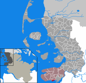
| Location of the community Vollerwiek in the district of North Friesland | ||
  |
||

Vollerwiek ( Danish : Follervig, Frisian : Folerwiik) is a municipality in the district of North Friesland in Schleswig-Holstein .
geography
Geographical location
The municipality of Vollerwiek is located in the southwest of the Eiderstedt peninsula . It follows directly adjacent to the north, the outside dike located tidal flats on Purrenstrom in Schleswig-Holstein region . The lands belonging to the municipal area are formed by the most south-westerly area of the historically smaller peninsula Eiderstedt (also called Thynning ), the Mühlenkoog and the Alten Westerkoog .
Community structure
In addition to the eponymous church village , the following districts are also located within the municipality:
- Altendeich
- battery
- Blocksberg
- Mill dike
- Mill koog
- Spannbüllhörn
- South dike
- Westerdeich

Neighboring communities
Borders on Vollerwiek as follows:
| Grothusenkoog | world | |
.svg)
|
Toenning | |
history
The Vollerwieker Church of St. Martin was founded by Garding in 1113 , and it is a predominantly Romanesque brick building with a surrounding cemetery. Its carved folding altar dates from around 1460, the large gallery pulpit from 1586/87. The north gallery is decorated with a painting from 1613 with scenes from the Old and New Testaments. Furthermore Bauernmalerei get -Gedenktafeln from the years 1759-1779. In the 19th century there was a considerable expansion to the west. The church was completely renovated in 1977.
politics
Community representation
The Voting Community Vollerwiek (WGV) holds all seven seats in the municipal council.
mayor
Hans-Jürgen Rosendahl (WGV) was elected mayor for the 2018–2023 election period.
economy
General
The municipality is predominantly agricultural. Another important source of income is tourism.
traffic
The municipal area is located off the trunk road network in Germany. In the eastern part, a short section of the state road 305 leads on the route from Wöhrden (where it branches off the federal road 203 ) to St. Peter-Ording through the municipality; a little further north the federal highway 202 in the section Tönning via Garding also to St. Peter-Ording.
The nearest train station is on the Husum – Bad St. Peter-Ording line in Garding .
Culture and sights
Personalities
Ralf Meister (* 1962), Bishop of the Evangelical Lutheran Regional Church in Hanover , was baptized in St. Martin's Church.
Web links
- Vollerwiek municipality
- Vollerwiek municipality at www.amt-eiderstedt.de
- Private website about Vollerwiek
Individual evidence
- ↑ North Statistics Office - Population of the municipalities in Schleswig-Holstein 4th quarter 2019 (XLSX file) (update based on the 2011 census) ( help on this ).
- ↑ see section of the historical map by Johannes Steenstrup Kort over Danmark Ældste Inddeling
- ↑ cf. Harry Kunz: Die Köge Nordfriesland , 2nd edition, Verlag Nordfriisk Instituut , Bräist / Bredstedt, 1999, ISBN 3-88007-251-5 , pp. 85/88
- ↑ cf. Housing directory Schleswig-Holstein 1987. (pdf) Retrieved on November 21, 2019 .
- ^ HW Wulf: Churches in Eiderstedt. Eiderstedt church district. (Brochure) o. O./o. J.

Vollerwiek bathing area

Farms in Vollerwiek


Achtrup | Ahrenshöft | Ahrenviöl | Ahrenviölfeld | Alkersum | Almdorf | Arlewatt | Aventoft | Bargum | Behrendorf | Bohmstedt | Bondelum | Bordelum | Borgsum | Bosbull | Braderup | Bramstedtlund | Bredstedt | Breklum | Dagebüll | Drage | Drelsdorf | Dunsum | Elisabeth-Sophien-Koog | Ellhöft | Emmelsbüll-Horsbüll | Narrow Sands | Fresendelf | Friedrich-Wilhelm-Lübke-Koog | Friedrichstadt | Galmsbüll | Garding | Garding, parish | Goldebek | Goldelund | Gröde | Grothusenkoog | Haselund | Hattstedt | Hattstedtermarsch | Högel | Spar | Hooge | Hörnum (Sylt) | Horstedt | Hude | Humptrup | Husum | Immenstedt | Joldelund | Kampen (Sylt) | Karlum | Katharinenheerd | Klanxbüll | Klixbull | Koldenbüttel | Kolkerheide | Kotzenbüll | Ladelund | Langeneß | Langenhorn | Leak | Lexgaard | List on Sylt | Löwenstedt | Lütjenholm | Midlum | Mildstedt | Fog | Neukirchen | Nieblum | Niebüll | Norddorf on Amrum | Norderfriedrichskoog | North beach | Norstedt | Ockholm | Oevenum | Oldenswort | Oldersbek | Olderup | Oldsum | Ostenfeld (Husum) | Oster-Ohrstedt | Osterhever | Pellworm | Poppenbüll | Ramstedt | Rantrum | Reußenköge | Risum-Lindholm | Rodenäs | Sankt Peter-Ording | Schwabstedt | Schwesing | Seeth | Simonsberg | Sollwitt | Sönnebüll | Sprakebull | Stadum | Stedesand | Struckum | South end | Süderhöft | Süderlügum | South March | Sylt | Tating | Tetenbull | Tinningstedt | Tönning | Tümlauer-Koog | Uelvesbüll | Uphusum | Utersum | Viöl | Vollerwiek | Vollstedt | World | Wenningstedt-Braderup (Sylt) | Wester-Ohrstedt | Westerhever | Westre | Winnert | Wipe | Witsum | Wittbek | Wittdün on Amrum | Joke word | Wobbenbüll | Wrixum | Wyk on Föhr