
Schwesing
| coat of arms | Germany map | |
|---|---|---|

|
Coordinates: 54 ° 30 ' N , 9 ° 8' E |
|
| Basic data | ||
| State : | Schleswig-Holstein | |
| Circle : | North Friesland | |
| Office : | Viöl | |
| Height : | 12 m above sea level NHN | |
| Area : | 15.63 km 2 | |
| Residents: | 956 (Dec. 31, 2019) | |
| Population density : | 61 inhabitants per km 2 | |
| Postal code : | 25813 | |
| Area code : | 04841 | |
| License plate : | NF | |
| Community key : | 01 0 54 118 | |
| Office administration address: | Westerende 41 25884 Viöl |
|
| Website : | ||
| Mayor : | Wolfgang Sokoll | |
| Location of the community Schwesing in the district of North Friesland | ||
  |
||

Schwesing ( Danish : Svesing , North Frisian : Swiasing ) is a municipality in the district of North Friesland on the west coast of Schleswig-Holstein .
geography
Geographical location
Schwesing is located east of Husum in the area of the historic Südgoesharde . The southern municipal boundary to the municipalities of Rantrum and Wittbek is mapped by the course of the Husumer Mühlenau .
Community structure
In addition to the eponymous village Schwesing, the localities Am Pfahl, Augsburg ( Augsborg ), Engelsburg ( Engelsborg ), Hohlacker ( Holager ) Spingwang and Süderholz ( Syderholt , also Sønderholt ) are located in the municipality.
Although derived from the main town of this community, Schwesing-Bahnhof is already in the neighboring community of Mildstedt .
Neighboring communities
Municipal areas directly bordering Schwesing are:
| Horstedt (North Friesland) | Olderup | Immenstedt (North Friesland) |
| Husum |
.svg)
|
Wester-Ohrstedt |
| Mildstedt | Rantrum | Wittbek |
history
The place was first mentioned in writing in 1435 as "Swesum". The place name is associated with the personal name Svese (see Svestad in Norway) or with the Svear who could have settled here. Schwesing has a church from the 13th century. The last supper cup of the Schwesingen church shows a boar and a brook on the underside, which may allow the name to be interpreted as "wild boar on the brook". The coat of arms can also be a later interpretation of the name.
According to legend, the search for the place to build the church was left to two young bulls. These were coupled to each other and let them pull. The church was built where the bulls camped at night. Bulls to find a building site corresponds to other church foundation sagas in Schleswig-Holstein .
After the annexation of Schleswig-Holstein by Prussia, a parish land municipality was formed from the area of the Schwesing parish . In addition to Schwesing, it included the five villages of Ahrenviöl , Hochviöl , Immenstedt , Oster-Ohrstedt and Wester-Ohrstedt .
In the Reichstag election in March 1933 , 90.6% voted for the NSDAP , 5.5% for the DNVP , 2.0% for the SPD and 0.2% for the KPD, with a turnout of 94.6%.
On April 1, 1934, the parish land community was dissolved, and the village communities formed independent rural communities. Hochviöl was incorporated into Viöl in 1976.
The Husum-Schwesing concentration camp was set up in the Engelsburg district in autumn 1944 (as a branch of the Neuengamme concentration camp ). The concentration camp prisoners were supposed to build the " Friesenwall ", a defense system against an Allied landing. Today there is a memorial on the site of the concentration camp.
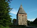
The Church of Schwesing

The coat of arms under the communion cup of the church

Husum-Schwesing concentration camp memorial

Entrance area of the Husum-Schwesing concentration camp memorial


Schools and kindergartens
The Protestant parish runs a kindergarten.
economy
General
Schwesing has a golf course in the Hohlacker district and a former military airfield in the Engelsburg district. Today this property is used by the anti-aircraft missile group 26 as a peace training position on the one hand, and by the Husumer Flughafen GmbH civil on the other .
traffic
The federal highway 201 runs through the village of Schwesing from Husum via Schleswig to Kappeln . The large municipal area is also crossed in the north-west by the federal highway 200 from Husum to Flensburg. The districts of Augsburg and Engelsburg are located here . Both roads form the backbone of supra-regional motorized individual traffic in the rural part of Schleswig.
The Husum – Kiel railway line also runs through the community (without a stop). The closest train station is that of Husum on the Marschbahn .
Attractions
The list of cultural monuments in Schwesing includes the cultural monuments entered in the list of monuments of Schleswig-Holstein.
Web links
Individual evidence
- ↑ North Statistics Office - Population of the municipalities in Schleswig-Holstein 4th quarter 2019 (XLSX file) (update based on the 2011 census) ( help on this ).
- ↑ Wolfgang Laur: Historisches Ortnamelexikon von Schleswig-Holstein , 2nd edition, Neumünster 1992, p. 592
- ^ Johannes Kok: Det danske folkesprog i Sønderjylland. Volume 2, København 1867, p. 391
- ↑ AKENS Information 39, Omland: "All of us 'yes' to the leader". Retrieved November 26, 2019 .
- ↑ State Statistical Office Schleswig-Holstein (Ed.): The population of the communities in Schleswig-Holstein 1867-1970 . State Statistical Office Schleswig-Holstein, Kiel 1972, p. 251 .
- ↑ Historical municipality register Schleswig-Holstein: Notes on the municipality Schwesing (footnote) . ( Digitized version ).
Achtrup | Ahrenshöft | Ahrenviöl | Ahrenviölfeld | Alkersum | Almdorf | Arlewatt | Aventoft | Bargum | Behrendorf | Bohmstedt | Bondelum | Bordelum | Borgsum | Bosbull | Braderup | Bramstedtlund | Bredstedt | Breklum | Dagebüll | Drage | Drelsdorf | Dunsum | Elisabeth-Sophien-Koog | Ellhöft | Emmelsbüll-Horsbüll | Narrow Sands | Fresendelf | Friedrich-Wilhelm-Lübke-Koog | Friedrichstadt | Galmsbüll | Garding | Garding, parish | Goldebek | Goldelund | Gröde | Grothusenkoog | Haselund | Hattstedt | Hattstedtermarsch | Högel | Spar | Hooge | Hörnum (Sylt) | Horstedt | Hude | Humptrup | Husum | Immenstedt | Joldelund | Kampen (Sylt) | Karlum | Katharinenheerd | Klanxbüll | Klixbull | Koldenbüttel | Kolkerheide | Kotzenbüll | Ladelund | Langeneß | Langenhorn | Leak | Lexgaard | List on Sylt | Löwenstedt | Lütjenholm | Midlum | Mildstedt | Fog | Neukirchen | Nieblum | Niebüll | Norddorf on Amrum | Norderfriedrichskoog | North beach | Norstedt | Ockholm | Oevenum | Oldenswort | Oldersbek | Olderup | Oldsum | Ostenfeld (Husum) | Oster-Ohrstedt | Osterhever | Pellworm | Poppenbüll | Ramstedt | Rantrum | Reußenköge | Risum-Lindholm | Rodenäs | Sankt Peter-Ording | Schwabstedt | Schwesing | Seeth | Simonsberg | Sollwitt | Sönnebüll | Sprakebull | Stadum | Stedesand | Struckum | South end | Süderhöft | Süderlügum | South March | Sylt | Tating | Tetenbull | Tinningstedt | Tönning | Tümlauer-Koog | Uelvesbüll | Uphusum | Utersum | Viöl | Vollerwiek | Vollstedt | World | Wenningstedt-Braderup (Sylt) | Wester-Ohrstedt | Westerhever | Westre | Winnert | Wipe | Witsum | Wittbek | Wittdün on Amrum | Joke word | Wobbenbüll | Wrixum | Wyk on Föhr