
Kotzenbüll
| coat of arms | Germany map | |
|---|---|---|

|
Coordinates: 54 ° 20 ' N , 8 ° 55' E |
|
| Basic data | ||
| State : | Schleswig-Holstein | |
| Circle : | North Friesland | |
| Office : | Eiderstedt | |
| Height : | 2 m above sea level NHN | |
| Area : | 7.77 km 2 | |
| Residents: | 200 (Dec. 31, 2019) | |
| Population density : | 26 inhabitants per km 2 | |
| Postal code : | 25832 | |
| Area code : | 04861 | |
| License plate : | NF | |
| Community key : | 01 0 54 072 | |
| Office administration address: | Welter Strasse 1 25836 Garding |
|
| Website : | ||
| Mayor : | Andreas Jacobs (DGK) | |
| Location of the municipality of Kotzenbüll in the district of North Friesland | ||
  |
||

Kotzenbüll ( Danish Kotzenbøl , also Kotsenbøl , North Frisian Kotzenbel ) is a municipality in the district of North Friesland in Schleswig-Holstein . Axendorf, Dorf, Kleihörn and Schwarzhof are in the municipality.
Geography and traffic
Kotzenbüll is located northwest of Tönning directly on the federal highway 202 from Kiel to Sankt Peter-Ording .
history
The place name probably means settlement of the Kotzos . The place name is mentioned for the first time in 1438, but the place is older. The first chapel already existed around 1300. Today's Nikolaikirche was completed in 1495 and testifies to the great wealth of the inhabitants of that time.
Due to the siege of the nearby Tönning fortress in 1713, the community suffered great losses. Most of the houses were burned down, including the former Stallerhof . Until then, the then prosperous parish had even been able to finance two clergymen, a pastor and a deacon . Since then the population has been falling, from 303 to 275 between 1795 and 1835 alone. Of the 13 hooded barges around 1800, only the Mars Skipper Hof is left today.
politics
Community representation
In the local elections on May 26, 2013, the electoral community DKG won all nine seats. The turnout was 71.9 percent.
mayor
Andreas Jacobs (DGK) has been elected mayor for the 2013–2018 election period. He succeeds Hans Boy Wolff, who was no longer a candidate.
economy
The municipality is predominantly agricultural.
Sons of the place
- Emil Wacker (1839–1913), Protestant theologian
- Wilhelm Hamkens (1896–1955), leader of the Schleswig-Holstein rural people movement
Attractions
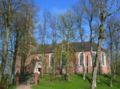
St. Nicholas Church

Main entrance door of St. Nikolai Church with late Gothic folding work

Nave of St. Nikolai Church 2015 - propped up due to acute danger of collapse
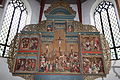
Altar of St. Nikolai Church

View from the churchyard of St. Nikolai Church over the moat to the surrounding area


.JPG)


Web links
Individual evidence
- ↑ North Statistics Office - Population of the municipalities in Schleswig-Holstein 4th quarter 2019 (XLSX file) (update based on the 2011 census) ( help on this ).
- ↑ for example in Jenning Dehn-Nilesen: Kirker i Sydslesvig , Flensburg / Flensborg 2017 and Otto Frederiks Vaupell: Den danske hærs historie til nutiden og den nordske hærs historie , København 1872, page 486
- ↑ Schleswig-Holstein topography. Vol. 5: Holt - Krokau . 1st edition Flying-Kiwi-Verl. Junge, Flensburg 2005, ISBN 978-3-926055-79-8 , pp. 332 ( dnb.de [accessed on July 20, 2020]).
- ↑ Hans Nicolai Andreas Jensen : Attempt at ecclesiastical statistics of the Duchy of Schleswig, Volume 2: Containing the Propsteien Tondern, Husum with Bredstedt, and Eiderstedt , Flensburg 1841, p. 793.
- ↑ [Wahlen.amt-eiderstedt.de/2013/kommunal/kotzenbüll.htm] accessed on May 27, 2013
Achtrup | Ahrenshöft | Ahrenviöl | Ahrenviölfeld | Alkersum | Almdorf | Arlewatt | Aventoft | Bargum | Behrendorf | Bohmstedt | Bondelum | Bordelum | Borgsum | Bosbull | Braderup | Bramstedtlund | Bredstedt | Breklum | Dagebüll | Drage | Drelsdorf | Dunsum | Elisabeth-Sophien-Koog | Ellhöft | Emmelsbüll-Horsbüll | Narrow Sands | Fresendelf | Friedrich-Wilhelm-Lübke-Koog | Friedrichstadt | Galmsbüll | Garding | Garding, parish | Goldebek | Goldelund | Gröde | Grothusenkoog | Haselund | Hattstedt | Hattstedtermarsch | Högel | Spar | Hooge | Hörnum (Sylt) | Horstedt | Hude | Humptrup | Husum | Immenstedt | Joldelund | Kampen (Sylt) | Karlum | Katharinenheerd | Klanxbüll | Klixbull | Koldenbüttel | Kolkerheide | Kotzenbüll | Ladelund | Langeneß | Langenhorn | Leak | Lexgaard | List on Sylt | Löwenstedt | Lütjenholm | Midlum | Mildstedt | Fog | Neukirchen | Nieblum | Niebüll | Norddorf on Amrum | Norderfriedrichskoog | North beach | Norstedt | Ockholm | Oevenum | Oldenswort | Oldersbek | Olderup | Oldsum | Ostenfeld (Husum) | Oster-Ohrstedt | Osterhever | Pellworm | Poppenbüll | Ramstedt | Rantrum | Reußenköge | Risum-Lindholm | Rodenäs | Sankt Peter-Ording | Schwabstedt | Schwesing | Seeth | Simonsberg | Sollwitt | Sönnebüll | Sprakebull | Stadum | Stedesand | Struckum | South end | Süderhöft | Süderlügum | South March | Sylt | Tating | Tetenbull | Tinningstedt | Tönning | Tümlauer-Koog | Uelvesbüll | Uphusum | Utersum | Viöl | Vollerwiek | Vollstedt | World | Wenningstedt-Braderup (Sylt) | Wester-Ohrstedt | Westerhever | Westre | Winnert | Wipe | Witsum | Wittbek | Wittdün on Amrum | Joke word | Wobbenbüll | Wrixum | Wyk on Föhr