
Tating
| coat of arms | Germany map | |
|---|---|---|

|
Coordinates: 54 ° 20 ' N , 8 ° 43' E |
|
| Basic data | ||
| State : | Schleswig-Holstein | |
| Circle : | North Friesland | |
| Office : | Eiderstedt | |
| Height : | 0 m above sea level NHN | |
| Area : | 29.49 km 2 | |
| Residents: | 958 (Dec. 31, 2019) | |
| Population density : | 32 inhabitants per km 2 | |
| Postal code : | 25881 | |
| Area code : | 04862 | |
| License plate : | NF | |
| Community key : | 01 0 54 134 | |
| Office administration address: | Welter Strasse 1 25836 Garding |
|
| Website : | ||
| Mayor : | Hans Jacob Peters ( CDU ) | |
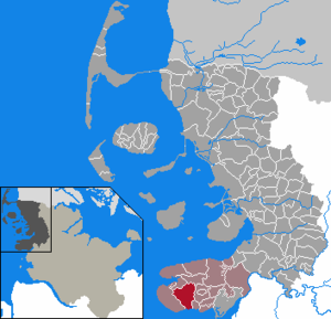
| Location of the municipality of Tating in the district of North Friesland | ||
  |
||

Tating ( North Frisian : Tååting ) is a municipality in the district of North Friesland in Schleswig-Holstein .
Geography and traffic
Geographical location
The municipality of Tating is located in the western part of the Eiderstedt peninsula . It is part of the Eiderstedter Marsch landscape and extends from the Wilhelminenkoog in the south to the Tümlauer-Koog on the bay of the same name in the north-west / north.
Neighboring communities
Adjacent municipal areas of Tating are:
| Tümlauer-Koog | Poppenbull | |
| Sankt Peter-Ording |
.svg)
|
Garding parish |
| Grothusenkoog |
history
Tating was the former capital of the Harde Utholm . It was first mentioned in a document in 1187.
The place is named after the archaeological find type Tatinger Kanne .
politics
Community representation
In the local elections on May 26, 2013, the CDU received 52.2% of the votes cast and occupied six seats. The General Tating Community of Voters (AWT) reached 47.8% and received five seats. The turnout was 49.9 percent.
mayor
Hans Jacob Peters (CDU) has been mayor since 2003. For the 2013–2018 electoral period, he was re-elected in the constituent community representative meeting.
coat of arms
Blazon : “Divided by silver and blue by a wide green and a narrow silver bar, lowered. Above a red hooded coffin, below a golden three-masted sailing ship in the style of the 16th century with silver sails and red pennants. On the main sail a half blue lion (leopard) looking out. "
Attractions

St. Magnus Church
The St. Magnus Church in Tating is the oldest church in Eiderstedt and perhaps the oldest building on the peninsula. In 1103 it was built as a wooden chapel , but over the centuries it has been expanded and rebuilt. The flat-vaulted single-nave main nave and the vaulted box choir are kept in Romanesque style, whereby the choir dates from the time of the first stone church, which replaced the wooden previous building soon after it was built. In the Gothic a domed choir polygon was added to the choir . The late Gothic winged altar shows a crucifixion scene rich in figures, which occupies its entire middle field. The twelve apostles are depicted in their wings, three each in a field. Today you can admire an abundance of cultural treasures from the past centuries during a tour: The pulpit from 1601, a triumphal cross group from the period after 1500, the north gallery from 1591 to 1601 as the remainder of the formerly more extensive galleries.
Hochdorf garden with Haubarg
One of the three most important garden monuments in North Friesland is located in Tating, namely the Hochdorf Garden. The approximately 4 hectare park was probably laid out in the French style in 1764. Its important elements are a linden parterre and ten axially symmetrical planting quarters aligned with the main front of the Hochdorf Haubarg , which are framed by linden avenues that are more than 120 meters long. The Haubarg itself, built in 1764, was 45 meters long and 23 meters wide and was probably the largest on Eiderstedt when it was built. At its best, the farm had 400 Demat land. Since the land decreased with several divisions, the Haubarg itself was also shortened by 16 meters. In keeping with the romantic taste of the time, a small artificial "ruin" was built on the southern edge of the garden.
While Haubarg is privately owned today, the garden belongs to the Richardsen Bruchwitz Foundation and is left to the community as a public village park. The "Swiss House", which today houses a restaurant with a gallery and is leased, also belongs to the Hochdorf garden.
traffic
The community can be reached by car via the federal road 202 in the section from Tönning to Sankt Peter-Ording. The main road leads directly through the village as a village road . Coming from the east, before reaching the village, Landesstraße 33 branches off on the left , which also runs to Sankt Peter-Ording and through the southern and eastern outer areas of the municipality.
For local rail passenger transport , Tating is reached via the Husum – Bad St. Peter-Ording line . The regional train 64 runs on this in the local transport network Schleswig-Holstein . In addition, the site is also in school bus traffic through the company car power to neighboring areas connected (bus lines from 1079 to 1081). The municipality is part of the St. Peter-Ording on- call bus area with the transfer point at the St. Peter-Ording Bahnhof Süd station .
The municipality of Tating is integrated in the officially signposted cycling network Schleswig-Holstein . The German long-distance cycle route D-Route 1 ( North Sea Coast Route (also: North Sea Coast Cycle Path) ) runs through the municipality . This maps the German section of the international North Sea Cycle Route (EV 12) . In addition, the themed route Wikinger-Friesen-Weg leads through the municipality.
Sons and daughters of the church
- Theodor Bannier (1883–?), Politician ( MdL , Schleswig-Holstein)
- Hans Tete Boye Ahrens (1876–1955), painter and graphic artist
photos

St. Magnus Church (front view)

St. Magnus Church (rear view)

Hochdorf garden

Hochdorfer Haubarg
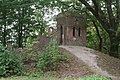
Artificial ruin in the Hochdorf Garden


Web links
Individual evidence
- ↑ North Statistics Office - Population of the municipalities in Schleswig-Holstein 4th quarter 2019 (XLSX file) (update based on the 2011 census) ( help on this ).
- ↑ Nordfriesland map, Bredstedt / Braist 2011, ISBN 978-3-88007-371-5
- ↑ Schleswig-Holstein's coat of arms
- ^ A b c Wolfgang Teuchert in Heinz Rudolf Rosemann (ed.): Lower Saxony, Hanseatic cities, Schleswig-Holstein, architectural monuments , Reclams art guide, Germany, Volume 5, 4th edition. Stuttgart 1971, p. 142.
- ↑ Wolfgang Teuchert in Heinz Rudolf Rosemann (Ed.): Lower Saxony, Hanseatic cities, Schleswig-Holstein, architectural monuments. Reclams Art Guide, Germany, Volume 5, 4th edition. Stuttgart 1971, p. 142.
- ↑ See timetable download at www.autokraft.de (search term: Tating). Retrieved May 14, 2020 .
- ↑ Flyer on-call bus area St. Peter-Ording. (pdf) Retrieved May 14, 2020 .
- ↑ . See information site in German wiki by OpenStreetMap (Link: DE: cycling network Schleswig-Holstein. Retrieved on May 14, 2020 . )
Achtrup | Ahrenshöft | Ahrenviöl | Ahrenviölfeld | Alkersum | Almdorf | Arlewatt | Aventoft | Bargum | Behrendorf | Bohmstedt | Bondelum | Bordelum | Borgsum | Bosbull | Braderup | Bramstedtlund | Bredstedt | Breklum | Dagebüll | Drage | Drelsdorf | Dunsum | Elisabeth-Sophien-Koog | Ellhöft | Emmelsbüll-Horsbüll | Narrow Sands | Fresendelf | Friedrich-Wilhelm-Lübke-Koog | Friedrichstadt | Galmsbüll | Garding | Garding, parish | Goldebek | Goldelund | Gröde | Grothusenkoog | Haselund | Hattstedt | Hattstedtermarsch | Högel | Spar | Hooge | Hörnum (Sylt) | Horstedt | Hude | Humptrup | Husum | Immenstedt | Joldelund | Kampen (Sylt) | Karlum | Katharinenheerd | Klanxbüll | Klixbull | Koldenbüttel | Kolkerheide | Kotzenbüll | Ladelund | Langeneß | Langenhorn | Leak | Lexgaard | List on Sylt | Löwenstedt | Lütjenholm | Midlum | Mildstedt | Fog | Neukirchen | Nieblum | Niebüll | Norddorf on Amrum | Norderfriedrichskoog | North beach | Norstedt | Ockholm | Oevenum | Oldenswort | Oldersbek | Olderup | Oldsum | Ostenfeld (Husum) | Oster-Ohrstedt | Osterhever | Pellworm | Poppenbüll | Ramstedt | Rantrum | Reußenköge | Risum-Lindholm | Rodenäs | Sankt Peter-Ording | Schwabstedt | Schwesing | Seeth | Simonsberg | Sollwitt | Sönnebüll | Sprakebull | Stadum | Stedesand | Struckum | South end | Süderhöft | Süderlügum | South March | Sylt | Tating | Tetenbull | Tinningstedt | Tönning | Tümlauer-Koog | Uelvesbüll | Uphusum | Utersum | Viöl | Vollerwiek | Vollstedt | World | Wenningstedt-Braderup (Sylt) | Wester-Ohrstedt | Westerhever | Westre | Winnert | Wipe | Witsum | Wittbek | Wittdün on Amrum | Joke word | Wobbenbüll | Wrixum | Wyk on Föhr