
Haselund
| coat of arms | Germany map | |
|---|---|---|

|
Coordinates: 54 ° 36 ' N , 9 ° 11' E |
|
| Basic data | ||
| State : | Schleswig-Holstein | |
| Circle : | North Friesland | |
| Office : | Viöl | |
| Height : | 18 m above sea level NHN | |
| Area : | 12.79 km 2 | |
| Residents: | 882 (Dec. 31, 2019) | |
| Population density : | 69 inhabitants per km 2 | |
| Postal code : | 25855 | |
| Area code : | 04843 | |
| License plate : | NF | |
| Community key : | 01 0 54 041 | |
| Office administration address: | Westerende 41 25884 Viöl |
|
| Website : | ||
| Mayor : | Jan Thormählen (AADW) | |
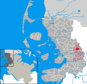
| Location of the municipality Haselund in the district of North Friesland | ||
  |
||

Haselund ( Danish : Haselund or Haslund , Jutland : Haslinj ) is a municipality in the district of North Friesland in Schleswig-Holstein . Brook (Danish: Brok ), Kollund, Norderkollundfeld, Osterkollundfeld, Neukrug ( Nykro ), Haselundfeld and Brookfeld are in the municipality.
Geography and traffic
Haselund is located about 18 km northeast of Husum on the federal highway 200 from Husum to Flensburg .
history
Around 8000 BC There was a "settlement point" in what is now the municipality, as evidenced by some small devices.
The place name Haselund is first documented in writing in 1352. It means enclosed grove, enclosed wood and goes in Danish. has for enclosure, fence, scabbard and lund for grove, wood back. The place name Brook is first attested in 1483. The name may refer to the Niederdt. brook back for a break . An interpretation according to old north is not excluded. or old Danish. brōk . Kollund is documented for the first time in 1483 and means jackdaw grove, a jackdaw tree, going back to ancient Danish. kā for jackdaw. Based on the oral southern Jutland form in Viöler Danish Kølinj is also an interpretation for wood, where heavy sticks were brought to Danish. Kølle for club possible.
Before the German-Danish War in 1864, the three places Brook, Haselund and Kollund were part of the parish Viöl ( Fjolde ) within the Nordergoesharde within the Duchy of Schleswig . During the Prussian period, the villages were part of the parish district of Viöl in the Husum district. This was dissolved on April 1, 1934. Many of their villages, village communities and farmers became independent communities / rural communities, including Brook, Haselund and Kollund. On December 1, 1934, the communities Brook, Haselund and Kollund were merged to form the new community Haselund.
politics
Community representation
Of the eleven seats in the municipal council, the electoral community AADW received four seats, the SPD one , due to the officially determined election results in the 2018 local elections . The electoral community AWH occupied two seats during this electoral period; the WGE three seats.
coat of arms
Blazon : “Divided by green and gold by a sloping bar divided into confused colors. Above a golden beef head, below a golden coffee pot, below a green peat spade. "
Economy and Infrastructure
The community and especially the Haselund district is predominantly agricultural, with the dairy industry occupying a prominent position. There are also a number of businesses in the municipality.
Haselund has a primary school, which is also attended by children from the neighboring community of Löwenstedt .
Web links
Individual evidence
- ↑ North Statistics Office - Population of the municipalities in Schleswig-Holstein 4th quarter 2019 (XLSX file) (update based on the 2011 census) ( help on this ).
- ^ General letters Videnskabernes Selskab Kaart over Slesvig, Sydvestre Blad (5). Copenhagen Royal Library.Retrieved July 3, 2020 .
- ↑ Bjerrum differently: Kær, Vis and Ugle Herreder together with Joldelund and Fjolde Sogne . In: Anders Bjerrum, Kristian Hald and Peter Jørgensen (eds.): Sydslesvigs stednavne . tape IV . Copenhagen 1979, p. 451 .
- ↑ Schleswig-Holstein topography. Vol. 4: Groß Sarau - Holstenniendorf . 1st edition Flying-Kiwi-Verl. Junge, Flensburg 2004, ISBN 978-3-926055-75-0 , p. 144 ( dnb.de [accessed on May 2, 2020]).
- ↑ Wolfgang Laur: Historisches Ortsnamelexikon von Schleswig-Holstein , 2nd edition, Neumünster 1992, p. 311
- ↑ Wolfgang Laur: Historisches Ortnamelexikon von Schleswig-Holstein , 2nd edition, Neumünster 1992, p. 184
- ↑ Johannes Kok: Det danske folkesprog i Sønderjylland , Volume 2, Copenhagen 1867, p. 99
- ↑ Wolfgang Laur: Historisches Ortnamelexikon von Schleswig-Holstein , 2nd edition, Neumünster 1992, p. 403
- ^ The population of the communities in Schleswig-Holstein 1867–1970 . State Statistical Office Schleswig-Holstein, Kiel 1972, p. 251 .
- ↑ Notes on the municipality of Haselund . In: Historical municipality register Schleswig-Holstein . ( genealogy.net footnote).
- ↑ Announcement of the municipal election results in the municipality of Haselund. (PDF) Retrieved December 16, 2018 .
- ↑ Schleswig-Holstein's municipal coat of arms
Achtrup | Ahrenshöft | Ahrenviöl | Ahrenviölfeld | Alkersum | Almdorf | Arlewatt | Aventoft | Bargum | Behrendorf | Bohmstedt | Bondelum | Bordelum | Borgsum | Bosbull | Braderup | Bramstedtlund | Bredstedt | Breklum | Dagebüll | Drage | Drelsdorf | Dunsum | Elisabeth-Sophien-Koog | Ellhöft | Emmelsbüll-Horsbüll | Narrow Sands | Fresendelf | Friedrich-Wilhelm-Lübke-Koog | Friedrichstadt | Galmsbüll | Garding | Garding, parish | Goldebek | Goldelund | Gröde | Grothusenkoog | Haselund | Hattstedt | Hattstedtermarsch | Högel | Spar | Hooge | Hörnum (Sylt) | Horstedt | Hude | Humptrup | Husum | Immenstedt | Joldelund | Kampen (Sylt) | Karlum | Katharinenheerd | Klanxbüll | Klixbull | Koldenbüttel | Kolkerheide | Kotzenbüll | Ladelund | Langeneß | Langenhorn | Leak | Lexgaard | List on Sylt | Löwenstedt | Lütjenholm | Midlum | Mildstedt | Fog | Neukirchen | Nieblum | Niebüll | Norddorf on Amrum | Norderfriedrichskoog | North beach | Norstedt | Ockholm | Oevenum | Oldenswort | Oldersbek | Olderup | Oldsum | Ostenfeld (Husum) | Oster-Ohrstedt | Osterhever | Pellworm | Poppenbüll | Ramstedt | Rantrum | Reußenköge | Risum-Lindholm | Rodenäs | Sankt Peter-Ording | Schwabstedt | Schwesing | Seeth | Simonsberg | Sollwitt | Sönnebüll | Sprakebull | Stadum | Stedesand | Struckum | South end | Süderhöft | Süderlügum | South March | Sylt | Tating | Tetenbull | Tinningstedt | Tönning | Tümlauer-Koog | Uelvesbüll | Uphusum | Utersum | Viöl | Vollerwiek | Vollstedt | World | Wenningstedt-Braderup (Sylt) | Wester-Ohrstedt | Westerhever | Westre | Winnert | Wipe | Witsum | Wittbek | Wittdün on Amrum | Joke word | Wobbenbüll | Wrixum | Wyk on Föhr