
Ostenfeld (Husum)
| coat of arms | Germany map | |
|---|---|---|
_Wappen.png)
|
Coordinates: 54 ° 28 ' N , 9 ° 13' E |
|
| Basic data | ||
| State : | Schleswig-Holstein | |
| Circle : | North Friesland | |
| Office : | North Sea Treene | |
| Height : | 46 m above sea level NHN | |
| Area : | 27.67 km 2 | |
| Residents: | 1521 (Dec. 31, 2019) | |
| Population density : | 55 inhabitants per km 2 | |
| Postal code : | 25872 | |
| Area code : | 04845 | |
| License plate : | NF | |
| Community key : | 01 0 54 099 | |
| Office administration address: | Schulweg 19 25866 Mildstedt |
|
| Website : | ||
| Mayoress : | Eva-Maria Kühl ( CDU ) | |
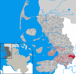
| Location of the community of Ostenfeld (Husum) in the district of North Friesland | ||
  |
||

Ostenfeld (Husum) ( Danish : Østerfjolde or Ostenfeld , Frisian : Aastenfäil , South Jutian : Østenfjolj ) is a municipality in the district of North Friesland in Schleswig-Holstein . The districts of Brendhörn, Drellborg, Ostenfeldfeld, Rott (Danish Rød ), Schmöl ( Smøl ) and Stumpen belong to Ostenfeld .
Geography and traffic

Ostenfeld is about twelve kilometers east of Husum and borders the Schleswig-Flensburg district in the east .
The natural area is characterized by the Ostenfelder Geest (as part of the Schleswig Geest ) and the Eider-Treene lowland . The Sandesberg is located in the municipality , with a height of 53.5 m, the highest point in the North Friesland district.
history
The place name Ostenfeld (Østerfjolde) is first documented in writing in 1352. He probably describes the location of the place as east of Viöl ( * østen æ Fjolj ), whereby Fjolj / Fjolde (Viöl) can refer not only to the place, but also to the region. The ending -feld shows an early German reinterpretation of the basic word, unlike in today's German place name Viöl. Fjolde itself means something like outer market, uncultivated area . In some cases, with reference to the dialectic Jutland form of Ostenfeld (Mdän. Øssenfjylj or Østenfjolj ), a connection to oxen ( Yssen ) was established.
The place name Rott (Rød) was first documented in 1438. It could be a takeover of the Danish form for clearing (old Danish * Ruth or * Roth , Mdän. * Roj ) into Low German with the corresponding final hardening, but which also occurs in purely Low German place names.
The place name Schmöl (Smøl) is first documented at the end of the 18th century. It is also spread several times north of the border and probably denotes slash and burn. A derivation from old north is also possible . smár- (≈small, low) and -bøl (≈siedlung) for small settlement .
Drellborg (in German also Drellburg ) was first documented in 1570 and means slave castle to old north. þræll and old Danish. thræll for unfree, slave, servant . Similar names can be mentioned in the entire Scandinavian region (see þrælaborg near Oslo or Trelleborg in Skåne ). In present-day Denmark the name can be found around thirty times. A metaphorical name of thrræl (l) for a curved beam or pillar was also adopted. The place name is therefore probably associated with an earlier castle, which, however, has not yet been proven with certainty.
Until the German-Danish War in 1864, the place was the center of the Ostenfeld parish within the Südergoesharde in the Duchy of Schleswig, which belongs to Denmark . After the duchies of Schleswig and Holstein were annexed by Prussia , a parish land municipality was formed from the area of the Ostenfeld parish . It comprised the three villages of Ostenfeld, Winnert and Wittbek . After the estate districts were dissolved, part of the Gottorf forest estate district was incorporated into the village of Ostenfeld. On April 1, 1934, the parish rural communities were dissolved, and the village communities have since formed independent rural communities, including the main town of Ostenfeld. On November 1, 1970, the community of Ostenfeld (Husum district) was officially renamed Ostenfeld (Husum) .
politics
Of the 13 seats in the municipal council has CDU since the local elections in 2013 eight seats, the voter community AWGO five.
coat of arms
Blazon : "Above a blue corrugated shield base in gold, ending with a silver corrugated bar, a red tip, inside a golden Romanesque baptismal font."
Economy and Infrastructure


Many retail and service companies have settled in the community.
Special
.jpg)
In Prussian times, the original survey for the land tax cadastre was carried out in all of Schleswig-Holstein, which was based on the Prussian polygon network from the years 1873 to 1875, in which new polygons were added to the existing points. For the survey points and the marketed border points in western Schleswig-Holstein, right-angled Soldner coordinates have been calculated to the zero point Ostenfeld (St. Petri church tower).
Attractions
literature
- Chronicle of the Ostenfeld community . Reprint of the village chronicle by Magnus Voss from 1905. Husum Druck- und Verlagsgesellschaft, Husum 1995, ISBN 978-3-88042-751-8
Web links
Individual evidence
- ↑ North Statistics Office - Population of the municipalities in Schleswig-Holstein 4th quarter 2019 (XLSX file) (update based on the 2011 census) ( help on this ).
- ↑ Schleswig-Holstein topography. Vol. 7: Munkbrarup - Pohnsdorf . 1st edition Flying-Kiwi-Verl. Junge, Flensburg 2006, ISBN 978-3-926055-88-0 , p. 272 ( dnb.de [accessed on July 22, 2020]).
- ↑ Wolfgang Laur: Historisches Ortsnamelexikon von Schleswig-Holstein , 2nd edition, Neumünster 1992, p. 504
- ↑ Wolfgang Laur: Historisches Ortsnamelexikon von Schleswig-Holstein , 2nd edition, Neumünster 1992, p. 251
- ↑ Wolfgang Laur: Historisches Ortsnamelexikon von Schleswig-Holstein , 2nd edition, Neumünster 1992, p. 504
- ↑ Wolfgang Laur: Historisches Ortsnamelexikon von Schleswig-Holstein , 2nd edition, Neumünster 1992, p. 555
- ↑ Wolfgang Laur: Historisches Ortsnamelexikon von Schleswig-Holstein , 2nd edition, Neumünster 1992, p. 579
- ↑ See Johannes Kok: Det danske folkesprog i Sønderjylland. Volume 2, København 1867, p. 361
- ^ Wolfgang Laur: Historical place-name dictionary of Schleswig-Holstein. 2nd edition, Neumünster 1992, p. 220
- ↑ State Statistical Office Schleswig-Holstein (Ed.): The population of the communities in Schleswig-Holstein 1867-1970 . State Statistical Office Schleswig-Holstein, Kiel 1972, p. 251 .
- ^ Federal Statistical Office (ed.): Historical municipality directory for the Federal Republic of Germany. Name, border and key number changes in municipalities, counties and administrative districts from May 27, 1970 to December 31, 1982 . W. Kohlhammer, Stuttgart / Mainz 1983, ISBN 3-17-003263-1 , p. 182 .
- ↑ Schleswig-Holstein's municipal coat of arms
Achtrup | Ahrenshöft | Ahrenviöl | Ahrenviölfeld | Alkersum | Almdorf | Arlewatt | Aventoft | Bargum | Behrendorf | Bohmstedt | Bondelum | Bordelum | Borgsum | Bosbull | Braderup | Bramstedtlund | Bredstedt | Breklum | Dagebüll | Drage | Drelsdorf | Dunsum | Elisabeth-Sophien-Koog | Ellhöft | Emmelsbüll-Horsbüll | Narrow Sands | Fresendelf | Friedrich-Wilhelm-Lübke-Koog | Friedrichstadt | Galmsbüll | Garding | Garding, parish | Goldebek | Goldelund | Gröde | Grothusenkoog | Haselund | Hattstedt | Hattstedtermarsch | Högel | Spar | Hooge | Hörnum (Sylt) | Horstedt | Hude | Humptrup | Husum | Immenstedt | Joldelund | Kampen (Sylt) | Karlum | Katharinenheerd | Klanxbüll | Klixbull | Koldenbüttel | Kolkerheide | Kotzenbüll | Ladelund | Langeneß | Langenhorn | Leak | Lexgaard | List on Sylt | Löwenstedt | Lütjenholm | Midlum | Mildstedt | Fog | Neukirchen | Nieblum | Niebüll | Norddorf on Amrum | Norderfriedrichskoog | North beach | Norstedt | Ockholm | Oevenum | Oldenswort | Oldersbek | Olderup | Oldsum | Ostenfeld (Husum) | Oster-Ohrstedt | Osterhever | Pellworm | Poppenbüll | Ramstedt | Rantrum | Reußenköge | Risum-Lindholm | Rodenäs | Sankt Peter-Ording | Schwabstedt | Schwesing | Seeth | Simonsberg | Sollwitt | Sönnebüll | Sprakebull | Stadum | Stedesand | Struckum | South end | Süderhöft | Süderlügum | South March | Sylt | Tating | Tetenbull | Tinningstedt | Tönning | Tümlauer-Koog | Uelvesbüll | Uphusum | Utersum | Viöl | Vollerwiek | Vollstedt | World | Wenningstedt-Braderup (Sylt) | Wester-Ohrstedt | Westerhever | Westre | Winnert | Wipe | Witsum | Wittbek | Wittdün on Amrum | Joke word | Wobbenbüll | Wrixum | Wyk on Föhr