
Fresendelf
| coat of arms | Germany map | |
|---|---|---|

|
Coordinates: 54 ° 24 ' N , 9 ° 15' E |
|
| Basic data | ||
| State : | Schleswig-Holstein | |
| Circle : | North Friesland | |
| Office : | North Sea Treene | |
| Height : | 5 m above sea level NHN | |
| Area : | 2.6 km 2 | |
| Residents: | 89 (Dec 31, 2019) | |
| Population density : | 34 inhabitants per km 2 | |
| Postal code : | 25876 | |
| Area code : | 04884 | |
| License plate : | NF | |
| Community key : | 01 0 54 032 | |
| Office administration address: | Schulweg 19 25866 Mildstedt |
|
| Website : | ||
| Mayor : | Hans Peter Lorenzen (WG) | |
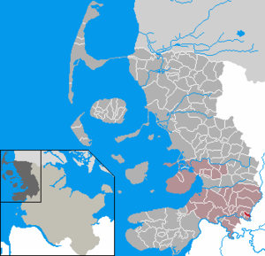
| Location of the community Fresendelf in the district of North Friesland | ||
  |
||

Fresendelf is a municipality in the district of North Friesland in Schleswig-Holstein .
geography
Geographical location
Fresendelf is located in the silt area of the Schleswig Geest on the western bank of the Treenetal near Schwabstedt . To the south of the town on the edge of the municipality of Süderhöft, the Treenelauf swings in a westerly direction.
Neighboring communities
Fresendelf borders on:
| Schwabstedt | Schwabstedt (OT Hollbüllhuus) | |
| Hude |
.svg)
|
Bergenhusen |
| Süderhöft |
traffic

The connection to the community Fresendelf is mainly done by car . The North Frisian district road 31 runs through the village . It branches off from Landesstraße 38 in an easterly direction at the Treenebrücke in Schwabstedt and leads back to the same in an arch. The confluence is north of the Schwabstedter village center in the district of Lehmsiek .
The designated state road forms a cross connection between Seeth (connection to federal road 202 ) and Oster-Ohrstedt ( federal road 201 ).
In public transport Fresendelf is using since August 2019 call bus connections to the neighboring Schwabstedt. In addition, during school hours there is also a regular service between Husum and Schwabstedt via Fresendelf (bus line 1062). Operation on this line is currently (as of 2019) by the bus company Autokraft .
history
The place name means Friesengraben and was first mentioned in a document in the 15th century.
On December 1, 1934, the parish district of Schwabstedt was dissolved. All of their village communities, village communities and farmers became independent communities / rural communities, including Fresendelf.
After the population had dropped to 70 in the 1980s and the population grew older, this trend was reversed in the mid-1980s.
politics
Community representation
Since the local elections in 2008, the community of voters WG has all seven seats in the local council. In the local elections on May 26, 2013, the turnout was 78.0 percent, and in the subsequent election on May 6, 2018, it was 79.5 percent.
mayor
For the 2013–2018 election period, Hans Peter Lorenzen (WG) was re-elected mayor.
Others
The place was 2013 entrance into the world of music by the eponymous song originally from the year Husum coming German punk band Turbostaat .
Web links
Individual evidence
- ↑ North Statistics Office - Population of the municipalities in Schleswig-Holstein 4th quarter 2019 (XLSX file) (update based on the 2011 census) ( help on this ).
- ↑ Flyer on-call bus area Schwabstedt. (pdf) Accessed November 10, 2019 .
- ↑ Timetable Bus 1062. (pdf) Retrieved on November 10, 2019 .
- ↑ Wolfgang Laur : Historisches Ortsnamelexikon von Schleswig-Holstein , 2nd edition, Neumünster 1992, p. 257.
- ↑ State Statistical Office Schleswig-Holstein (Ed.): The population of the communities in Schleswig-Holstein 1867-1970 . State Statistical Office Schleswig-Holstein, Kiel 1972, p. 251 .
- ↑ Schleswig-Holstein topography. Vol. 3: Ellerbek - Groß Rönnau . 1st edition Flying-Kiwi-Verl. Junge, Flensburg 2003, ISBN 978-3-926055-73-6 , p. 144–145 ( dnb.de [accessed April 22, 2020]).
- ↑ Result of Fresendelf local election 2013
- ↑ Result Fresendelf KW 2018. Accessed on May 31, 2019 .
Achtrup | Ahrenshöft | Ahrenviöl | Ahrenviölfeld | Alkersum | Almdorf | Arlewatt | Aventoft | Bargum | Behrendorf | Bohmstedt | Bondelum | Bordelum | Borgsum | Bosbull | Braderup | Bramstedtlund | Bredstedt | Breklum | Dagebüll | Drage | Drelsdorf | Dunsum | Elisabeth-Sophien-Koog | Ellhöft | Emmelsbüll-Horsbüll | Narrow Sands | Fresendelf | Friedrich-Wilhelm-Lübke-Koog | Friedrichstadt | Galmsbüll | Garding | Garding, parish | Goldebek | Goldelund | Gröde | Grothusenkoog | Haselund | Hattstedt | Hattstedtermarsch | Högel | Spar | Hooge | Hörnum (Sylt) | Horstedt | Hude | Humptrup | Husum | Immenstedt | Joldelund | Kampen (Sylt) | Karlum | Katharinenheerd | Klanxbüll | Klixbull | Koldenbüttel | Kolkerheide | Kotzenbüll | Ladelund | Langeneß | Langenhorn | Leak | Lexgaard | List on Sylt | Löwenstedt | Lütjenholm | Midlum | Mildstedt | Fog | Neukirchen | Nieblum | Niebüll | Norddorf on Amrum | Norderfriedrichskoog | North beach | Norstedt | Ockholm | Oevenum | Oldenswort | Oldersbek | Olderup | Oldsum | Ostenfeld (Husum) | Oster-Ohrstedt | Osterhever | Pellworm | Poppenbüll | Ramstedt | Rantrum | Reußenköge | Risum-Lindholm | Rodenäs | Sankt Peter-Ording | Schwabstedt | Schwesing | Seeth | Simonsberg | Sollwitt | Sönnebüll | Sprakebull | Stadum | Stedesand | Struckum | South end | Süderhöft | Süderlügum | South March | Sylt | Tating | Tetenbull | Tinningstedt | Tönning | Tümlauer-Koog | Uelvesbüll | Uphusum | Utersum | Viöl | Vollerwiek | Vollstedt | World | Wenningstedt-Braderup (Sylt) | Wester-Ohrstedt | Westerhever | Westre | Winnert | Wipe | Witsum | Wittbek | Wittdün on Amrum | Joke word | Wobbenbüll | Wrixum | Wyk on Föhr